2 months after I suggested CDOT simplify their bike map, I mapped 2023 projects myself. 1 week later CDOT released a simplified map.

Update 12/4/23, 9 AM: As noted below, on September 21 I suggested on Twitter that the Chicago Department of Transportation simplify the color scheme on its Chicago Bikeway Map, which shows all bike lanes installed in Chicago to-date. CDOT Complete Streets manager David Smith and I also discussed the topic a bit during our October interview about the department’s 2023 bike lane projects, which was published on November 1.
The Streetsblog article below, with our map of bikeways installed or underway in 2023, and a simpler color code, was published on November 21. That day I emailed the post to Smith and CDOT spokesperson Erica Schroder via email, and asked if they had any corrections or updates. They didn’t immediately respond.
On November 27 I got the following email from Schroeder:
“Thanks for sharing. Somewhat related, I wanted to highlight that today we launched a new Complete Streets website at Chicago.gov/CompleteStreets. It includes an updated and expanded version of our previous Bike Network page with a more user-friendly interface. The website also has specific pages dedicated to traffic safety, pedestrian programs, and transit infrastructure that I think you and Streetsblog readers will find useful.”
“Chicago.gov/bikeways and Chicago.gov/bikes will direct you right to the new ‘Bikeways Program’ page. And Chicago.gov/bikemap will direct you to the ‘Existing Bike Network’ page.
I gave some of the new websites a quick look. The next day I tweeted it out the Complete Streets website via the Streetsblog account, with the intention of taking a deeper dive into the new sites in the future.
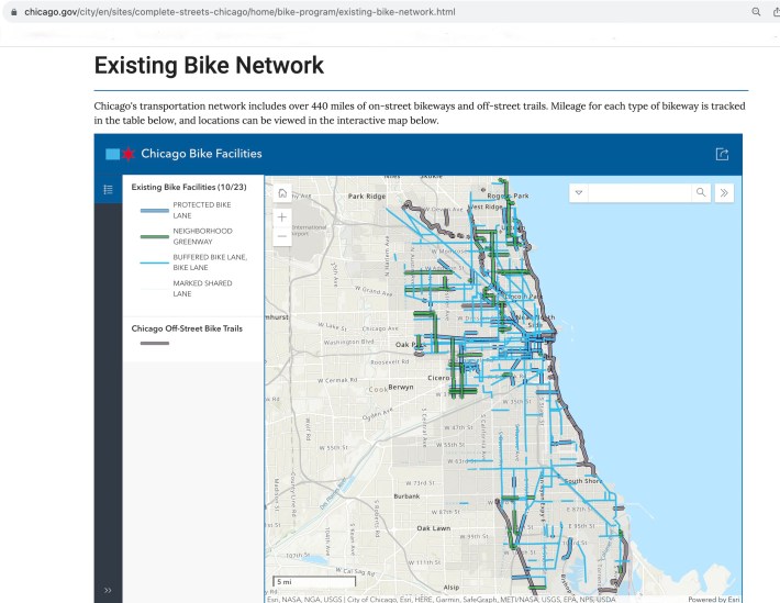
This morning I noticed that the new CDOT bike map page features a revised map that uses a simpler sidebar code, similar to what Streetsblog suggested and eventually used in our 2023 Chicago Bikeway Installations map. The links to the old CDOT Bike Network web page and map, which we linked to below and screen-shotted above, no longer work. So use the links Schroeder sent, above, if you want to see how CDOT is keeping track of bikeways nowadays.
View CDOT’s map of all bikeways installed in Chicago in the modern era (including 2023) here. [Link no longer works.]
The Chicago Department of Transportation’s CDOT Bike Network webpage [Link no longer works] has been a great resource to find out what’s been going on during our city’s busy 2023 bikeway installation schedule. I often use it to check out the department’s interactive Chicago Bike Network map, which was last updated in late September of this year. Also useful is the list of 2023 Bikeway Installations at the bottom of the page, with relevant streets listed alphabetically under “Installed,” “Underway,” and “Upcoming,” categories. (At this point in the construction season, the latter label probably means those projects will start work in spring 2024.)
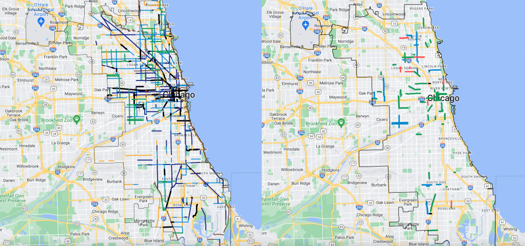
But I thought it would be useful to create a version of the bikeway map that only shows which projects have been completed in 2023, or are currently under construction. I also think the CDOT map’s color code is confusing, which I told the department two months ago.
On the CDOT map, it’s pretty hard to tell the difference between a “BIKE LANE” (blue), a “BUFFERED BIKE LANE (navy blue), a “PROTECTED BIKE LANE” (black), and a “OFF-STREET PATH” or “ACCESS PATH” (dark brown.)
So I simplified the color scheme for Streetsblog’s map. Green = curb-upgraded or new protected lanes. Blue = Neighborhood Greenways, side-street bike routes, often with contraflow (“wrong-way”) bike lanes and traffic calming. Black = shared lane markings, aka “sharrows” – bike-and-chevron symbols. And Red = non-protected bike lanes, including buffered, non-buffered, and dashed lanes. Hopefully that will make it a little easier to understand what’s been / being built.
Note that I purposely chose red to show non-protected, paint-only bike lanes on main streets. My goal is to highlight the fact that’s not a great design for the modern era. If the city expects people to use bike lanes on arterial streets where higher driving speeds are legal and/or common, it must provide bike riders with physical protection from motorists. Or to use a popular slogan nowadays, “Paint is not protection.” Fortunately, CDOT’s 2023 Chicago Cycling Strategy plan states that “85 percent of planned projects are low-stress [Neighborhood Greenway or protected] bikeways,” rather than paint-only lanes on main streets.
Another obvious thing you’ll see on Streetsblog’s map is that, while lots of bikeways were / are being installed on the North and West sides this year, the South Side is getting a lot fewer miles. That discrepancy may explain why CDOT chose not to release a map like Streetsblog’s, only showing 2023 projects. In addition there were virtually no bikeway projects on the Far Northwest and Far Southwest sides, where most Donald Trump voters live, this year.
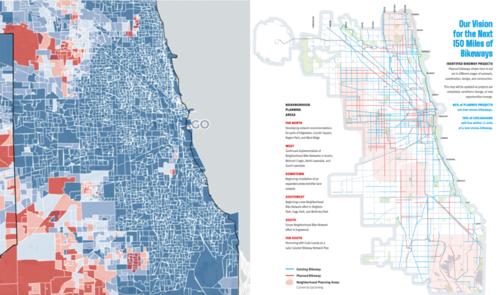
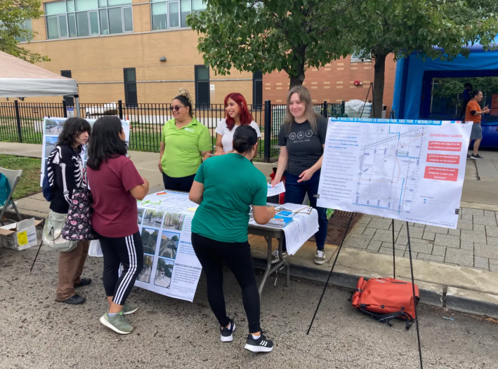
The good news, as CDOT’s Complete Streets manager David Smith indicated in a recent interview, is many more miles of bikeways will be built on the South Side next year, thanks to the department’s Neighborhood Bike Network project. It focuses on underserved neighborhoods, with increased opportunity for community input on street design.
“Over the last two years we’ve implemented about 50 miles of projects, just on the West Side, through the Neighborhood Bike Networks, and those are neighborhoods that historically did not have much in terms of cycling infrastructure,” Smith said. Look for new installations on the South and Southwest sides’ Brighton Park, McKinley Park, and Gage Park communities in the near future.
As for the Southeast Side, CDOT has an effort in partnership with Cook County in the Lake Calumet region to improve biking in that part of town. Similar to the Neighborhood Bike Networks project, they’re working with community members “to identify a network of streets that connect people to meaningful destinations like the Burnham Greenway, Big Marsh Park, things like that,” Smith said.
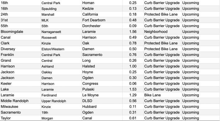
To get a preview of which new bikeways are (most likely) slated for 2024, check out the list of “Upcoming” projects at the bottom of the bottom of the CDOT Bike Network webpage [Link no longer works], or the screenshot of that list below. Streetsblog might do another map in the near future to make the locations of these planned routes more obvious.
In the meantime, if you’ll be in Chicago for the long Thanksgiving break, instead of spending money on Black Friday purchases, why not “opt outside” and explore some of the new bikeways highlighted on our map, by bicycle? Whether you’ve already checked out these routes, or only learned about them from Streetsblog’s map, feel free to let us know what you think of these bikeways in our comment section.
View CDOT’s map of all bikeways installed in Chicago in the modern era (including 2023) here. [Link no longer works.]
Here’s the list of “Upcoming” bikeways (likely 2024) from the bottom of the CDOT Bike Network webpage:

Did you appreciate this post? Please consider making a tax-deductible donation.

Read More:
Streetsblog has migrated to a new comment system. New commenters can register directly in the comments section of any article. Returning commenters: your previous comments and display name have been preserved, but you'll need to reclaim your account by clicking "Forgot your password?" on the sign-in form, entering your email, and following the verification link to set a new password — this is required because passwords could not be carried over during the migration. For questions, contact tips@streetsblog.org.