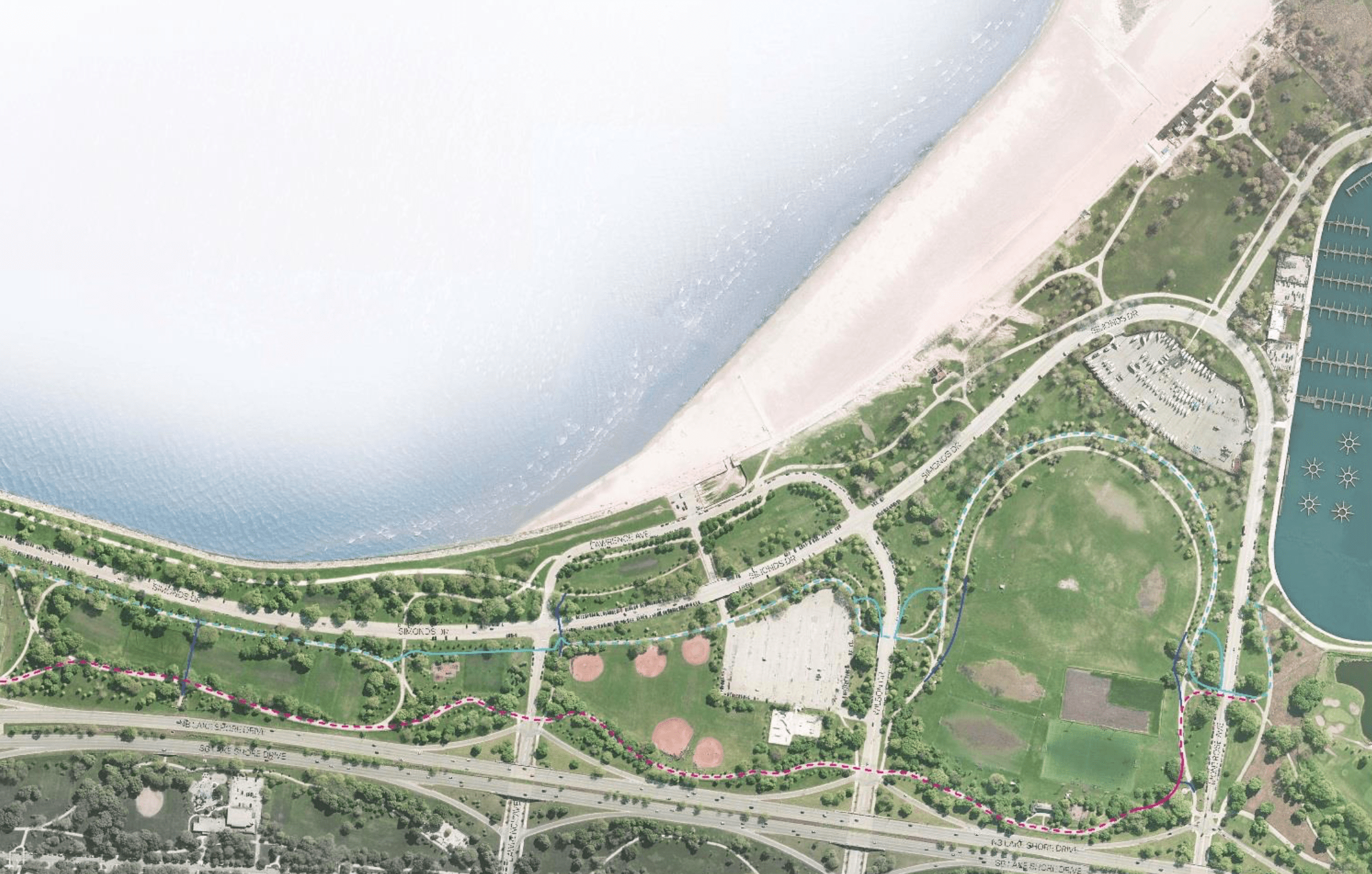
Plans for Lakefront Trail separation between the northern terminus of the path and Montrose Avenue will add an extra half-mile to shoreline bicycle commutes, but cyclists will be rewarded some nice lake views south of Foster Avenue. Both bike riders and pedestrians will be required to detour east from the trail’s current Montrose crossing -- which will be eliminated -- to an underpass, making it easier for motorists to drive to the beach.
At last Wednesday’s Mayor’s Bicycle Advisory Council meeting, Chicago Park District project manager Michael Lange provided an update on the initiative to separate pedestrian and bike traffic along virtually the entire length of the 18.5-mile trail. This ambitious project was made possible by a $12 million gift from billionaire hedge fund manager Ken Griffith, who is also the largest outside contributor to Illinois governor Bruce Rauner’s campaign fund.
The park district plans to complete the work next year. The stretch between 31st and 41st streets was recently completed, and segments between Fullerton and North avenues, and Oak and Ohio streets, are nearly finished, Lange said.

In general, the new pedestrian-only route will be located closer to Lake Michigan, while the new bike-only route will run closer to Lake Shore Drive and its noise and exhaust. An exception to the rule will be a section of the upcoming project section between Ardmore and Montrose, which will begin construction this fall, likely wrapping up next spring.
Between Ardmore Avenue (the north end of the trail) and Foster, cyclists will use the existing Lakefront Trail, while a new route will be created for pedestrians that will run close to Osterman and Foster beaches. However, at Foster Avenue the routes will switch places, with pedestrians taking over the existing trail.
Bike riders will be routed east, past the Foster beach house and around a large parking lot. After that, the bike route crosses Simonds Drive, a coastal road, and runs south of the drive, using an existing underpass to cross Wilson Avenue. Next, the bike route detours east to circumnavigate Cricket Hill, the popular kite-flying and sledding spot.
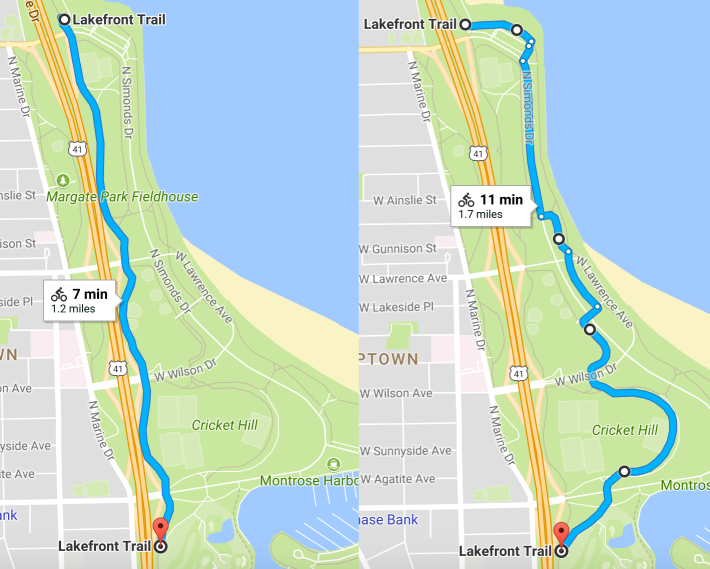
Lange explained that the decision was made to have cyclists take the longer lakeside route south of Foster because it would have been an “excessive detour” for pedestrians. Referring to the fact that the lakefront between Foster and Montrose also features several soccer fields and baseball diamonds, a running track and a skate park, he added, “This is also a huge recreation corridor, so we wanted to make sure people who are walking have the ability to access these facilities quickly.”
East of Cricket Hill, the pedestrian and bike routes will meet up again to go through an underpass beneath Montrose Avenue, located about a block east of the current, at-grade intersection of the Lakefront Trail intersection with the avenue. This junction is a hot spot for crashes, probably partly due to confusing, illogical signage. While drivers on Montrose have a stop sign, path users have a yield sign, making it unclear who’s supposed to cede the right-of-way to whom.
The Lakefront Trail segment that currently crosses Montrose will be depaved and sodded over, so path users won’t have the option of making an at-grade crossing. Pedestrians and cyclists traveling on Montrose will be able to access the new trail via existing paths that parallel the avenue.
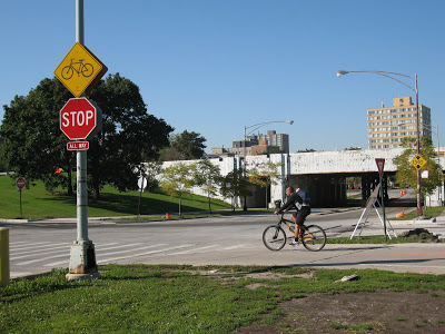
“One of the nice thing about pushing the bike trail eastward is that we force bicyclists to use the underpasses at Wilson and Montrose,” Lange said. “The really great benefit is that we’re taking bicycle and pedestrian crossings off of Montrose, so we’re removing a high conflict area.” This remark was met with applause and cheers from MBAC meeting attendees.
Of course, another reason to force pedestrians and cyclists to take this less direct viaduct route is to facilitate driving on Montrose, since motorists will no longer have to stop for trail users. As with the rest of the Lakefront Trail separation project, the redesign of the Ardmore-to-Montrose stretch was done with input from the city’s Office of Emergency Management and Communications, which helps make decisions about traffic routing, as well as the Active Transportation Alliance and the Chicago Area Runner’s Association. A public hearing on the project was held on August 1 at Margate Park.
So where do pedestrians and cyclists go after crossing Montrose via the same underpass? For the time being, both groups will head southeast on an existing path to the current Lakefront Trail, but the future of the trail segment between Montrose and Fullerton hasn’t been determined yet. The park district is still designing this section, where the presence of the Sidney R. Marovitz Golf Course, softball fields, tennis courts, and Belmont Harbor pose logistical challenges. As such, no public meetings are scheduled about this stretch yet.
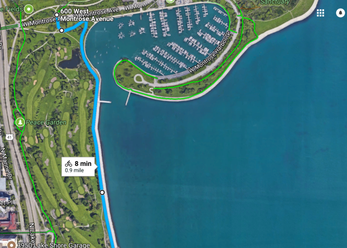
One possible solution that springs to mind would be to have pedestrians use the existing trail and route cyclists east from the viaduct to the shoreline next to Montrose Harbor, currently occupied by a rough gravel road, which is already great place to ride fat bikes or cross-country ski during the winter. Yes, this change would again make the bike route a bit less direct. But the awesome views of the lake and skyline would be worth the extra pedaling.
