Enthusiasm for curbs: Advocates applaud CDOT’s upgrades to protected lanes, suggest more improvements

In his July 21 edition of Alderman [Brendan] Reilly Reports, the downtown City Council member (42nd Ward) shared the good news that the Chicago Department of Transportation is gearing up to expand the city’s bike lane network by 150 miles. You can check out the plans on CDOT’s 2023 Chicago Cycling Strategy report.
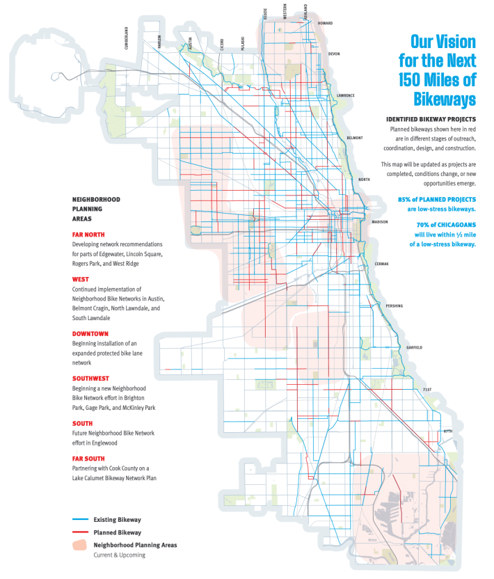
“Our vision for the next 150 miles of bikeways provides more than half a million more Chicagoans with access to low- stress bikeways,” the report states. “Currently, half of Chicagoans live within a half mile of a protected bike lane, neighborhood greenway, or off-street trail. Implementation of these projects will result in 70 percent of Chicagoans living within a half mile of a low-stress bikeway.”
As a bonus, Reilly noted in his newsletter, 85 percent of the new bike lanes will be protected by concrete curbs. CDOT is also planning to upgrade all existing paint-and-flexible-post protected lanes with curbs. He said the department would start installing curbs along the existing Clinton Street (530 W.) two-way protected bike lane between Harrison Street (600 S.) and Fulton Avenue (300 N.)
And Reilly said after that project was done, workers would putting curbs along the existing Randolph Street (130 N.) protected lane between Michigan Avenue (100 E.) and Canal Street (500 W.) They’d also upgrade the existing Washington Street (100 N.) protected lane between Wacker Drive (300 W.) and Michigan. The work was supposed to be finished by the end of August.
A Streetsblog reader, who lives in the South Loop and rides these streets regularly, shared a response to the news he emailed to Reilly. (The reader requested anonymity.) The resident applauded the plans but asked for some specifics, “since the devil is in the details.” Here’s what he asked and/or opined, followed by responses to his questions from CDOT, forwarded to him by the alder. We’ve added some notes in brackets, and links to articles on topics that were mentioned.
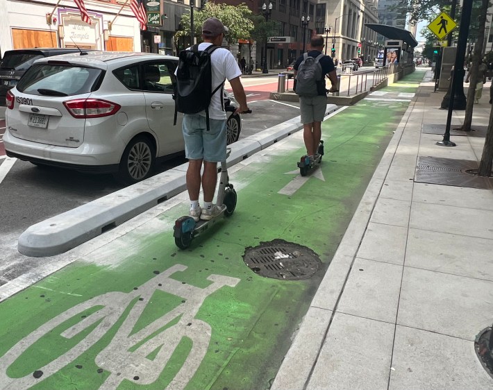
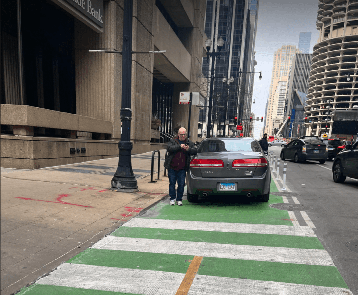
Citizen: “Recent installations have fallen short of keeping drivers out of bike lanes because drivers either park/enter at the intersections or high clearance vehicles straddle them. Is there a plan to improve upon the design at the entrances/exits or to install a vertical element?”
CDOT: “The Bike lanes are designed to maintain sufficient width for maintenance operations (sweeping/plowing). The recently passed Smart Streets Pilot Ordinance provides for the ability to increase enforcement efforts for bike lane infractions.”
[The ordinance allows ticketing by mail of cars illegally parked or standing in bike lanes, as well as bus lanes, crosswalks, bus stops, and no parking zones. The legislation allows for enforcement cameras to be fixed on city poles or on the front of city or CTA vehicles.]
Citizen: “There are several spots that frequently flood, such as Randolph just west of Wells [200 W.] Will drainage be improved in these problem areas so that cyclists won’t get trapped in an area flooded curb-to-curb?”
CDOT: “Thank you for identifying this location. We are investigating.”
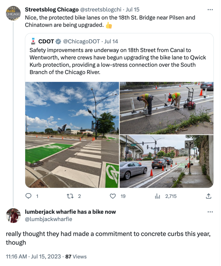
Citizen: “CDOT has been unwilling/unable to install curbs on [bike lanes on] bridges and bridge approaches. The Randolph [river] bridge and its approaches are one of the worst areas for drivers illegally blocking traffic. Are curbs being installed? If not, what’s the plan for this block?
CDOT: “Yes, curbs will be installed. There are specific protocols for drilling into and working on bridge approach slabs – we have a raised curb product [plastic Qwick Kurb] that will be used for the approaches to the bridge.”
[After CDOT tweeted images of a crew upgrading the 18th Street Bridge’s paint-and-post lanes with Qwick Kurb curbs and flexible posts, which are less durable than concrete curbs, on July 14, bike advocates asked why concrete wasn’t being used. After all, in June 2022 the department put out a press release titled, “Chicago To Upgrade All Protected Bike Lanes to Concrete by End of 2023.”
Streetsblog asked CDOT about this. “Installing precast concrete curbs on bridges risks drilling past the waterproof layer of the bridge deck, which could risk the long-term health of the bridge,” spokesperson Erica Schroeder responded. “Qwick Kurb was selected in consultation with CDOT’s bridge group and is the most robust barrier we are able to install on bridges at this time.]
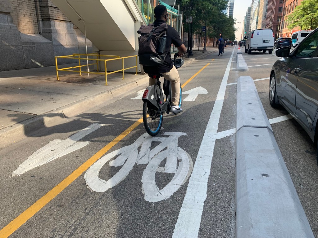
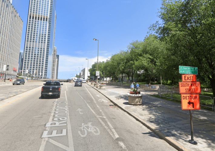
Citizen: “[The Washington St. non-protected bike lane] between Canal and Wacker Dr. [300 W. at this location] is another hot spot for bad driver behavior, but is noticeably missing [curbs]. Can curbs be installed on the western section of this block?”
CDOT: “[Upgrading the Washington protected lane with curbs] will begin at Wacker and continue east. However, there is a separate effort for Washington west of Wacker that is currently in Phase I [preliminary design.]”
[See the image and its caption below for a full explanation of what they’re talking about.]
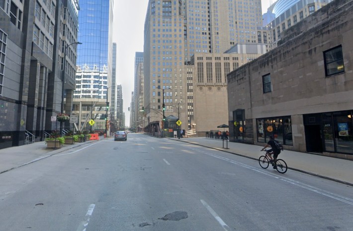
Citizen: “The improved Washington lane [the route heads north on Michigan for a block with no curb before connecting with Randolph, which provides access to Maggie Daley Park and the Lakefront Trail a few blocks east] dumps onto Michigan/Randolph. Can the curbs please be extended to at least the Upper/Middle Randolph split?”
[See our explanation of “the Upper/Middle Randolph split” in the image and its caption below.]
CDOT: “We are currently assessing this location.
The Streetsblog reader seemed reasonably satisfied with the transportation department’s responses, except for their answer to his first question about keeping drivers out of bike lanes. “I find the first response disappointing because CDOT is not even appearing to try to prevent drivers from entering bike lanes at intersections. I hope to see the Smart Streets Pilot implemented, but there hasn’t been much news from the city since it passed months ago.”
For another point of view on CDOT’s plan to upgrade all of Chicago’s protected bike lanes with curbs, we checked in with Olatunji Oboi Reed, founder of Equiticity, a nonprofit that promotes mobility justice in communities of color. He said said the group is in full support of making protected lanes safer.
Reed added that CDOT should encourage a sense of ownership of the bike network planning process by allowing community organizations and residents to oversee the process every step of the way.
Reed also said that the new curbs will alter how Black and Brown residents get around Chicago by making them feel safer. “In Black and Brown neighborhoods, we experience higher rates of traffic violence, unsafe infrastructure, and police stops. We are deeply concerned about interpersonal violence, vehicular violence, and police violence. Our neighborhoods have lower bicycle mode share and don’t enjoy a vibrant bicycle culture relative to predominantly white neighborhoods in our city. An expanded network of barrier-protected bike lanes will give more Black and Brown people the confidence to explore bikes as a form of transportation and commuting.”

Did you appreciate this post? Please consider making a tax-deductible donation.

Read More:
Streetsblog has migrated to a new comment system. New commenters can register directly in the comments section of any article. Returning commenters: your previous comments and display name have been preserved, but you'll need to reclaim your account by clicking "Forgot your password?" on the sign-in form, entering your email, and following the verification link to set a new password — this is required because passwords could not be carried over during the migration. For questions, contact tips@streetsblog.org.