Creating the Grace Greenway from the 312 River Run to the Lakefront Trail would be easy
Let’s say you’re at Addison Street and the Chicago River and you want to bike to Wrigleyville. Granted, that’s a very specific situation, but bear with me here. Maybe you’re coming from the 312 RiverRun, the off-street path corridor the city is developing along the river.
The 2020 version of the Chicago Department of Transportation’s Chicago Bike Map advises you to ride on Addison, a signed bike route. (Note that the new edition of the map shows signed routes as dashed lines rather than the solid ones used for bike lanes — it’s good that the map makes that distinction.) But personally, I’d never take Addison to make this trip. It’s a two-lane street, but a busy one with no bike lanes and a bus route.
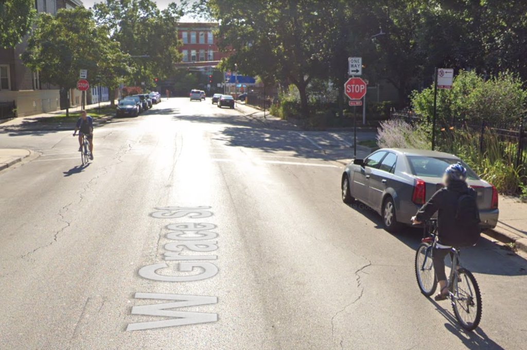
The Chicago Reader’s Mellow Chicago Bike Map, which I chose the routes for, shows a much lower-stress eastbound alternative. From Addison (3600 N.) east of the river, head north on Talman Avenue (2630 W.) passing by the Chicago Fire soccer field, and then east on Bradley Place (3730 N.) Then take the sidewalk at Campbell Avenue (2500 W.) half a block north to Grace (3800 N.) From there you can take Grace, a very chill side street, as far east as Broadway and Halsted Street (800 W.), with stoplights or four-way stop signs facilitating safe crossing of all the major street crossings.
This route also worked as a legal westbound itinerary between Ashland Avenue (1600 W.) and the river except for the one-block, one-way eastbound stretch of Grace between Lincoln (1900 W.) and Damen (2000 W.) avenues. But as it stood, westbound bike riders were deterred the “Do Not Enter” signs at Grace/Lincoln.
However, yesterday the city cleverly fixed that problem by installing a contraflow bike lane on that stretch. An article by Jake Wittich in Block Club hipped me to the upgrade. Presumably this idea was championed by local alderman Matt Martin, who has overseen several smart livable streets interventions in the 47th Ward since he took office last year.
🚲New contraflow bike lane alert🚲
Crews hard at work installing a new contraflow bicycle lane on Grace between Lincoln and Damen.
This lane, together with new bike traffic signals, will make it safer for cyclists using Grace in both directions. pic.twitter.com/TJMoqKbpiq
— Alderman Matt Martin (@AldMattMartin) October 6, 2020
With the simple act of striping 660 feet of green paint and posting a few signs, Martin and CDOT have essentially created a new “Neighborhood Greenway” bike priority route. It also would be good to promote this handy, tranquil corridor with wayfinding signs and bike-and-chevron “sharrow” markings on the pavement.
And if the city really wanted to go for the gold, they could add a couple more short stretches of contraflow lane on the one-way eastbound segment of Grace between Ashland and Southport Avenue (1400 W.), and the one-way westbound segment between Broadway/Halsted and Inner Lake Shore Drive. That would essentially create a new roughly three-mile, two-way family-friendly bike route all the way from the 312 RiverRun to the Lakefront Trail.
Granted, there’s already a neighborhood greenway half a mile south of Grace on Roscoe Avenue (3400 N., westbound) and School Street (3300 N., eastbound.) But this would be so cheap and easy, why the heck not?
Know any streets in other parts of town, especially the South and West sides, that could be transformed into neighborhood greenways with a few short stretches of contraflow? Tell us about them in the comments and we may run another post outlining the possibilities.

Read More:
Streetsblog has migrated to a new comment system. New commenters can register directly in the comments section of any article. Returning commenters: your previous comments and display name have been preserved, but you'll need to reclaim your account by clicking "Forgot your password?" on the sign-in form, entering your email, and following the verification link to set a new password — this is required because passwords could not be carried over during the migration. For questions, contact tips@streetsblog.org.