Work Has Started on the Leland Avenue Greenway in Uptown
After several years of delay and significant design changes, the Chicago Department of Transportation has finally started work on the Leland Avenue Greenway in Uptown. Construction recently began on a new landscaped promenade between the north and south buildings of Uplift Community High School, 900 West Wilson, which will include a short stretch of the bikeway.
The section of the Leland Greenway between Clark and the Lakefront Trail will lie within the 46th Ward, and hopefully the bikeway will be extended west past Clark into the 47th Ward, according to Tressa Feher, assistant to Uptown alderman James Cappleman. The quiet side-street route will serve as an alternative to busier Lawrence and Wilson avenues, a block north and south, respectively, which are also designated bike routes with “shared lane markings” (bike-and-chevron symbols, aka “sharrows.”)
Most of the route on Leland will include wayfinding signs, sharrows, and bike-friendly “sinusoidal” speed bumps, which have a lower profile than typical speed bumps. A routing challenge exists east of Sheridan at Arai Campus Park, just north of Uplift High, where Leland is cul-de-sac-ed. While a path runs around the north side of the park, the east side of the green space, where Leland resumes, is fenced off.
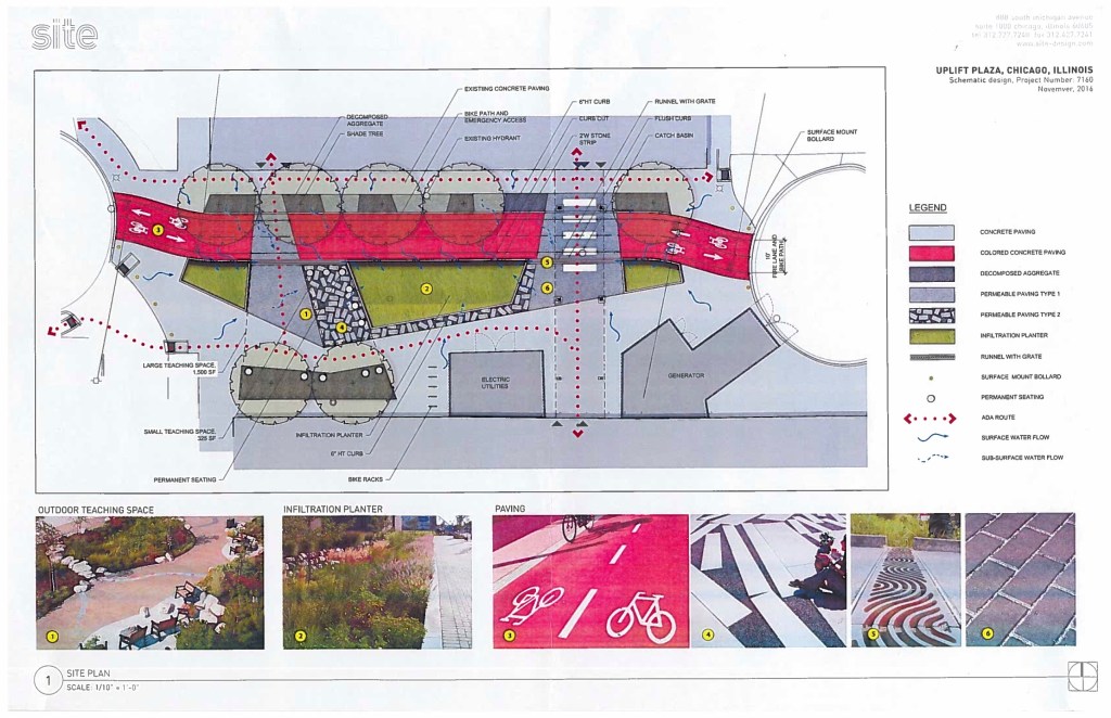
CDOT originally planned to run the greenway through the park, but the school administrators felt this would be unsafe for students, Feher says. Instead, the greenway will jog south half a block through an alley on the west side of the park to the promenade between the two school buildings. This plaza will include permeable surfaces and water infiltration planters, so it will double as an environmental teaching space for Uplift, Feher says.
After passing through the promenade, the route will continue east on Eastwood to Clarendon. At that point, cyclists who wish to continue north on the Lakefront Trail will head north to Lawrence and east to the trail, while southbound cyclists will use Wilson.
Last week CDOT began reconstructing both the Lawrence and Wilson viaducts under Lake Shore Drive, and the rehab projects will include the creation of sidewalk bike lanes on both sidewalks of each underpass. The 14-foot sidewalks will be divided into eight feet of pedestrian space and six feet of bike space with green pavement and bike symbols, separated by flexible plastic posts. The work on each viaduct will cost about $980,000, and the construction should take about eight months.
Streetsblog Chicago is not endorsing the sidewalk bike lane project. Due to the presence of access ramps for Lake Shore Drive on both sides of the viaducts, it may have been simpler and safer to instead convert mixed-traffic lanes beneath the underpasses to protected bike lanes. This would also have prevented potential conflicts between cyclists and pedestrians on the sidewalks.
In addition, the underpass reconstruction projects began with the eviction of longtime tent cities from both viaducts, without the provision of permanent housing for the homeless residents. While the city had no choice but to rehab the crumbling viaducts, it appears that a major motivation for installing bike lanes on the sidewalks is to make it impossible for the tent cities to return after construction is finished. Bike lanes should not be used as “defensive architecture” to prevent homeless individuals from occupying public space.
The issue of the viaducts aside, Tresser acknowledges that the slow progress of the Leland Greenway project has been somewhat frustrating for residents. She says ward money was allocated for the project back in late 2012 as part of a participatory budgeting election. “We thought the project was going to take two years. Constituents were really excited.”
However, there were complications. The city won a grant from the Environmental Protection Agency to build landscaped traffic circles and sidewalk bump-outs on Leland to serve as traffic calming, as well as storm water management. However, due to the presence of a water main on the street, those components had to be scrapped. The EPA money is instead being used for the Uplift High promenade.
CDOT also proposed installing a traffic diverter — infrastructure that would prevent drivers from using Leland as a cut-through route, but allow cyclists to continue unimpeded — at Leland and Beacon, as the west side of the project. “The local block club said absolutely not, so we didn’t even test it,” Feher says.
Getting approval for the routing at Uplift High involved two local school council hearings and three meetings with the school administration, which further delayed the greenway project, according to Feher. “The project has really changed over the years, so we’ll see what people think about it when we publicize it in our upcoming ward newsletter,” she says.
The street markings, signage, and speed bump work on Leland should be completed this fall, while the promenade will likely be completed next summer. “Even though I’m disappointed that we couldn’t do everything we wanted on Leland, I think the Uplift plaza is going to be really cool,” Feher says.

Read More:
Streetsblog has migrated to a new comment system. New commenters can register directly in the comments section of any article. Returning commenters: your previous comments and display name have been preserved, but you'll need to reclaim your account by clicking "Forgot your password?" on the sign-in form, entering your email, and following the verification link to set a new password — this is required because passwords could not be carried over during the migration. For questions, contact tips@streetsblog.org.