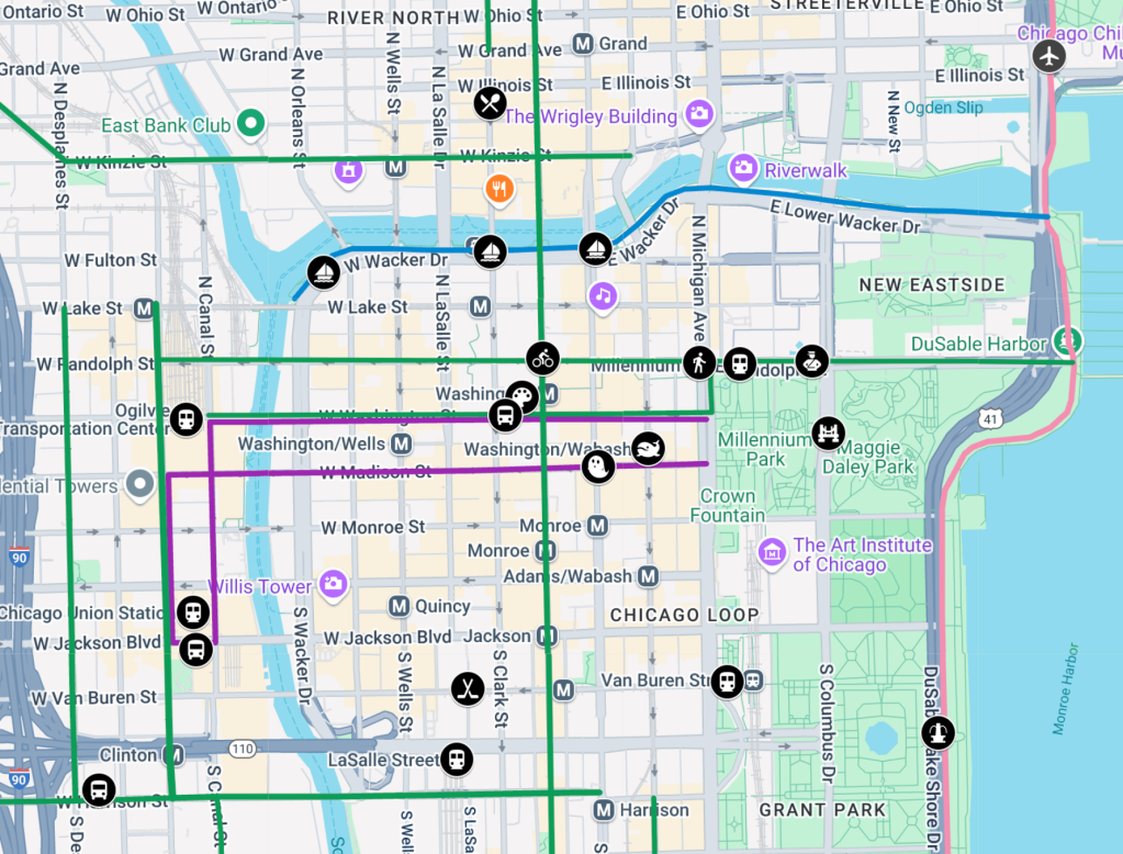
Feeling out of the Loop? Try our interactive map of walk/bike/transit landmarks in downtown Chicago
Recently, Streetsblog Chicago heard from Phil D’Anieri, Teaching Professor at the University of Michigan’s Department of Urban and Regional Planning. This week, he’s leading a class on a transportation-themed trip to the Windy City. These students are in a new degree program called Urban Technology, and they’ll be spending their time in Chicago looking at issues and opportunities related to sustainable transportation.
D’Anieri asked if SBC could recommend some locations for the students to check out, so I offered to put together a map of walk/bike/transit hotspots in or near the Loop, basically the city’s central business district. Below you’ll see what I came up with, followed by brief descriptions of each site and links to more info. My choices were influenced by feedback from Streetsblog followers on Bluesky and Twitter, some of which is featured at the bottom of this post.
Chicago visitors interested in urban planning and geography matters may also enjoy these previous SBC articles:
• Streetsblog’s Irreverent Guide to Chicago Planning Highlights and Lowlights
• A No-Crash Course in Navigating Chicago’s Street System
All right then, here’s the map I created for the U-Michigan students, which hopefully other folks will find useful as well.
Streetsblog Chicago’s interactive map. Click the square at the upper-right to view it full-screen.
Map elements, presented in no particular order. (If you’re using the above interactive Google Map for navigation, you can click on all of the circular black icons on to see the following descriptions with links.) For proportion, the distance between the Chicago Riverwalk (blue line on the map) and Ida B. Wells Drive (a highway-like “stroad” that’s the southern boundary of the central Loop) is roughly a mile.
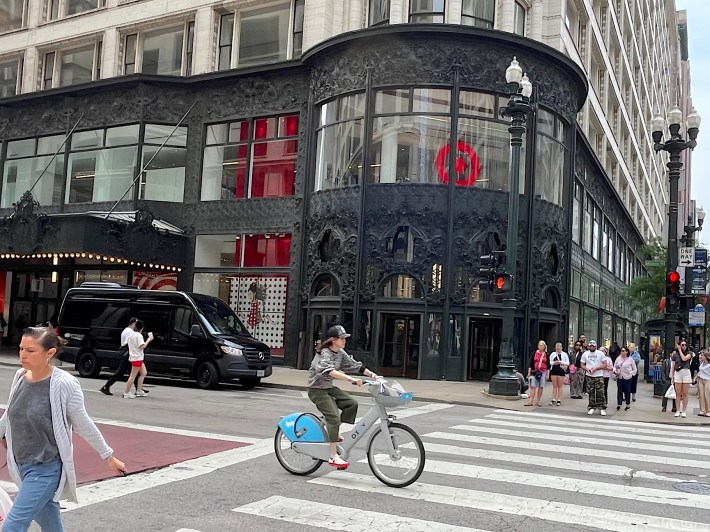
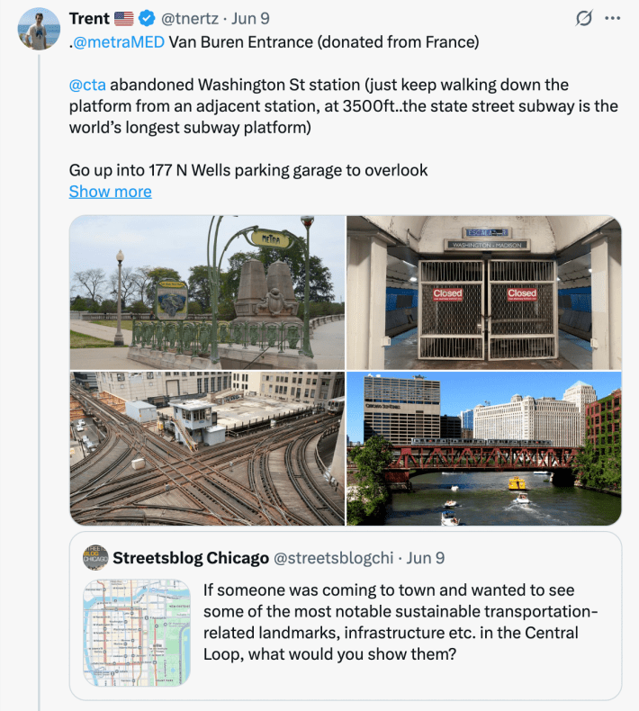
• Madison/State, “Goth Target” (ghost icon): The first thing to know about navigating our city is that Madison Street is Chicago’s north-south bifurcating street: Addresses on north-south streets are “North” north of Madison, and “South” south of it. Meanwhile, State Street is the city’s east-west bifurcating street: Addresses on east-west streets are “West” west of State and “East” east of it. Therefore the intersection of Madison and State is the city’s Ground Zero. At the southeast corner is the Louis Sullivan-designed Sullivan Center, currently home to a department store, with a dark, ornate entranceway that earned the store the nickname, “The Goth Target.”
• Daley Plaza (palette icon): Featuring the huge untitled 1967 sculpture called the Chicago Picasso for obvious reasons, this space hosts many special events, including the monthly (unsanctioned by the City) Chicago Critical Mass bicycle parade / protest / party.
• Intersection of two protected bike lanes (bike icon): This is the junction of the Dearborn Street two-way protected bike lane, and the Randolph Street PBL. This is sort of a “protected intersection.” Prior to installation of the concrete protection, it was common for drivers to crash into Petterino’s restaurant at the northwest corner.
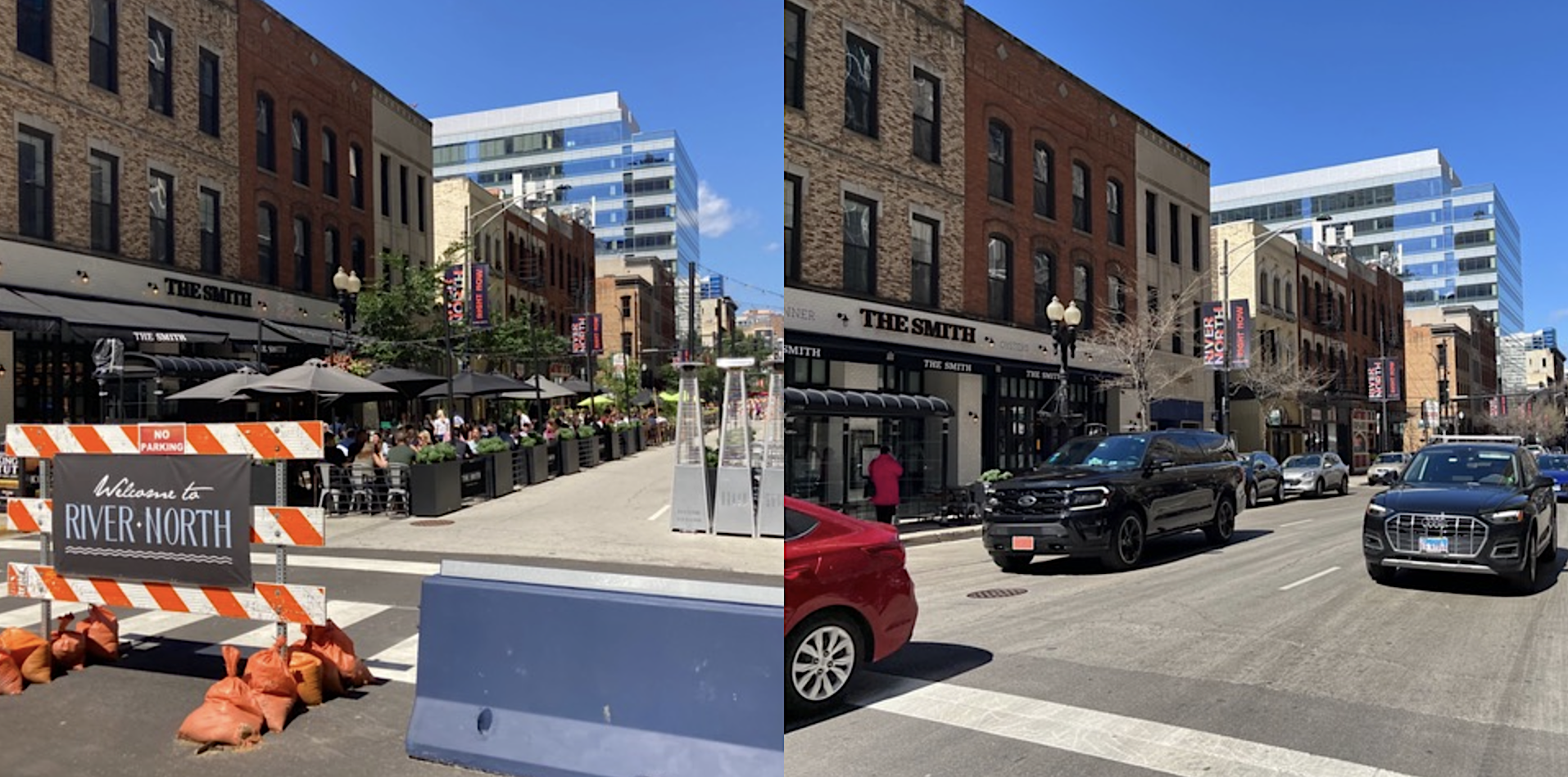
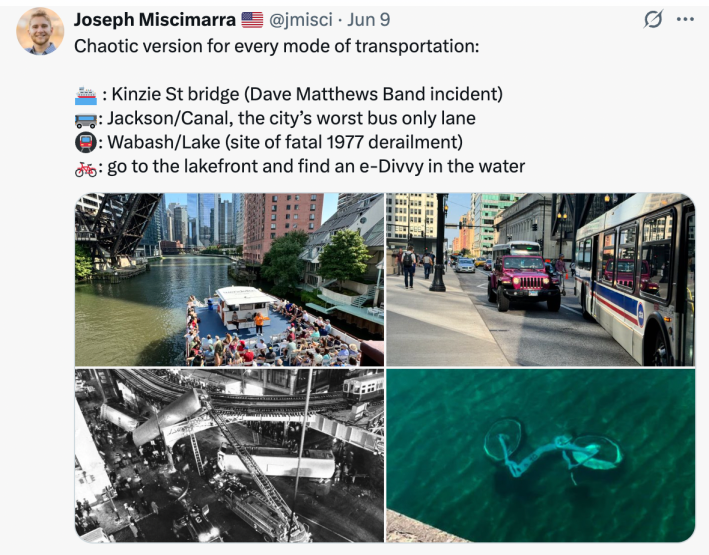
• Formerly car-free dining area (silverware icon): Clark Street between Grand Avenue and Kinzie Street in the River North nightlife area was completely pedestrianized during COVID-19 to make room for more outside dining. Unfortunately, due to pushback from some neighbors and restaurateurs on other nearby streets, the highly successful car-free district was reopened to motorized traffic in May 2024. However, dining establishments are still allowed to replace curbside parking spaces with seating areas during the warmer months.
• Loop Link “bus rapid transit lite” stop (bus icon): Across the street from Daley Plaza, this is an example of one of several giant Loop Link stops on Washington and Madison streets, space roughly every two blocks.
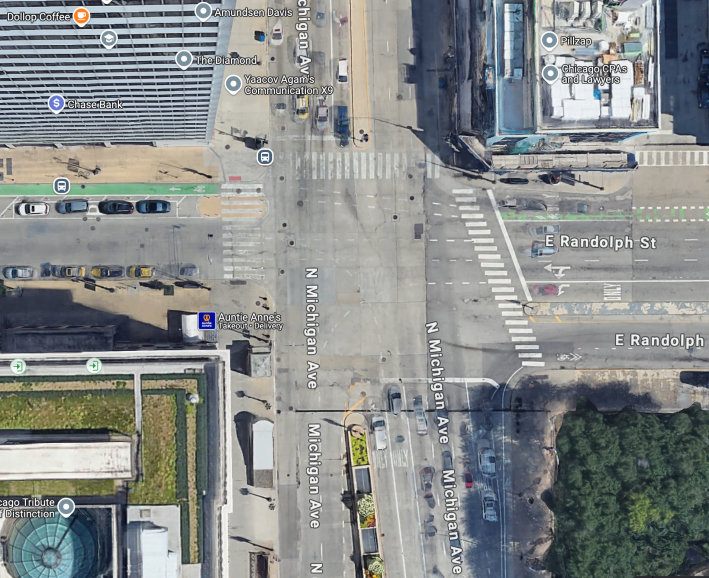
• Chicago’s Dumbest Intersection (pedestrian icon): At Randolph Street and Michigan Avenue, two of the city’s most important landmarks – the Chicago Cultural Center and Millennium Park – are directly across the street from each other, but you’re forced to cross the street three times to walk between them because there’s a missing crosswalk.
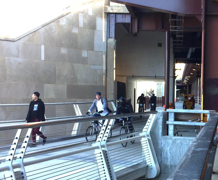
• BP Pedestrian Bridge (bridge icon): An attractive, serpentine span used to link Millennium Park and Maggie Daley Park, which are separated by pedestrian-hostile Columbus drive.
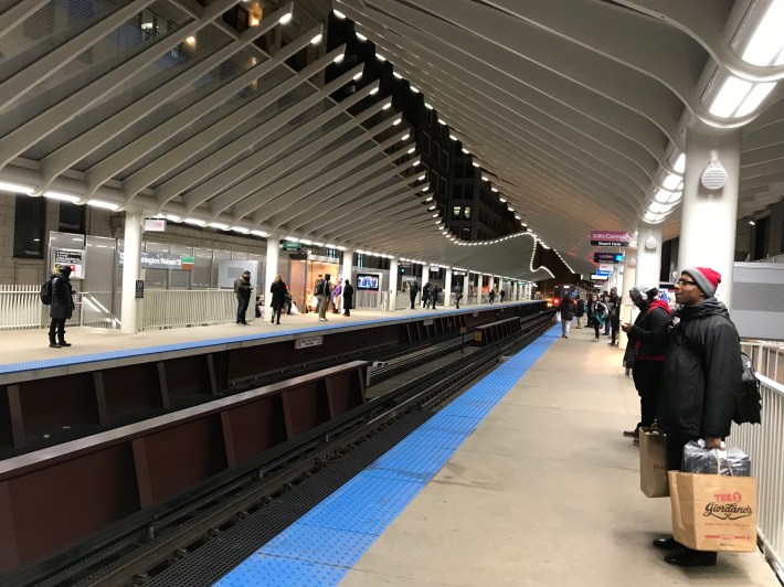
• Whalebone ‘L’ stop (whale icon): Officially the Washington-Wabash Station, it’s a nice-looking ‘L’ stop serving several routes on the sort-of-circular Loop Elevated corridor. The design was obviously inspired by the work of Spanish architect Sergio Calatrava, and I think it looks like Moby-Dick’s skeleton.
• Queen’s Landing Crosswalk (fountain icon): In 2005, to facilitate driving on [now-DuSable] Lake Shore Drive, then-mayor Richard M. Daley administration removed the pedestrian-activated stoplight and crosswalk between Buckingham Fountain and Queen’s Landing. In November 2011, progressive new Chicago transportation chief Gabe Klein had the crosswalk and signal reinstalled.
• Ex-Bike Station (police icon): When Millennium Park opened in 2004, it included a deluxe indoor bike parking structure offering repairs, showers, and lockers. Unfortunately, membership dropped during COVID-19, and by March 2023, the facility was permanently converted into a Chicago Police Department bike patrol headquarters, so there’s currently no public indoor bike parking facility in the Loop.
• Navy Pier Flyover (airplane icon): Completed in May 2021, after what seemed like an eternity of construction delays, this $64 million project was Illinois’ most expensive piece of bike infrastructure. It allows Lakefront Trail users to avoid dangerous street crossings near the Navy Pier tourist attraction, and provides stunning lake views.
• LaSalle/Van Buren ‘L’ stop (hockey sticks icon, a tribute to the late Canadian comedian John Candy): This station, serving the Loop Elevated route and the Chicago Board of Trade, was the setting of a key scene from Candy’s and Steve Martin’s beloved Thanksgiving movie, “Planes, Trains, and Automobiles.” The station’s role in the flick is discussed at 16:50 in this video.
• Greyhound station (bus icon): Last summer, Chicago was in danger of losing its Greyhound station due to lease issues, which would have made this the largest city in the northern hemisphere with no intercity bus facility, Fortunately, after heavy lobbying from sustainable transportation advocates, Greyhound’s owner FlixBus barely escaped eviction through a month-to-month lease agreement, but the issue is still in limbo.
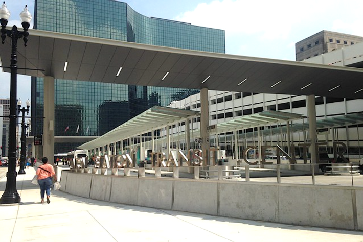
• Union Station Transit Center (bus icon): Opened in August 2016, this ground-level facility was built to allow passengers to transfer between CTA buses, and Amtrak and Metra trains without having to cross a busy street, using a tunnel under Jackson Boulevard. It doesn’t seem to be particularly well-used.
• Chicago Union Station (train icon): This building serves Amtrak, and Metra commuter rail trains to the southwest, western, and northwest suburbs. The facility is currently scheduled for a major rehab. It’s notable for its architecturally significant Great Hall, featured in the Al Capone movie “The Untouchables.”
• LaSalle Street Station (train icon): This fairly nondescript structure serves Metra commuter trains heading to the south and southwest suburbs.
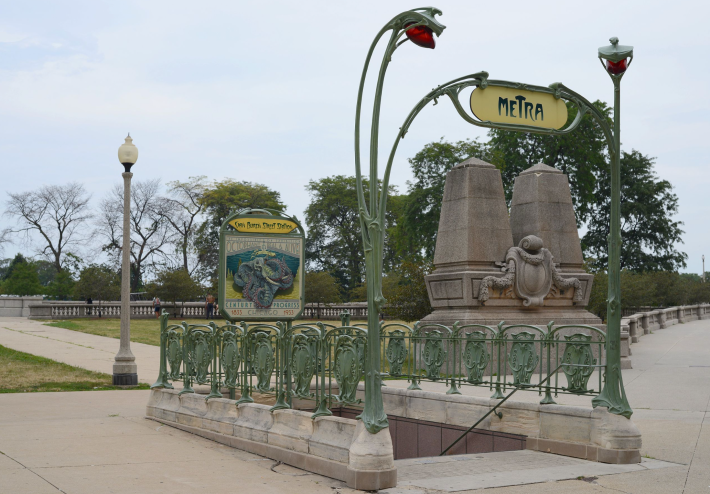
• Van Buren Street Station (train icon): This stop serves Metra Electric District trains to the south suburbs and South Shore Line trains to northwest Indiana. The latter route includes stops at the lovely Indiana Dunes. Last we checked, this station featured a vintage Parisian Metro-style entrance on Michigan Avenue, but unfortunately it was recently scheduled for removal as part of a station rehab project.
• Millennium Station (train icon): This stop, with lots of options for food and beverages to bring on the train, serves Metra Electric District trains to the south suburbs, and South Shore Line runs to northwest Indiana. Fortunately, you can get there from the Chicago Cultural Center by taking stairs at the southwest corner of Randolph/Michigan down to a tunnel under ten-lane wide Michigan Avenue. That entrance also a good place to access the city’s fairly extensive Pedway System during business hours.
• Ogilvie Transportation Center (train icon): This station, located in an interesting postmodern, cash register-shaped building, serves Metra commuter trains to the west, northwest, and northern suburbs. The latter include several upscale ‘burbs featured in ’80s John Hughes teen comedies. There’s a fast food court on the first floor, as well some interesting options in the attached French market.
• Loop Link route (purple lines): Opened in December 2015, this “bus rapid transit lite” route has (sporadically enforced) bus-only lanes, limited stops to speed trips, some traffic signal priority for buses, and level boarding, but no prepaid boarding.
• Lakefront Trail (pink line): runs 18.5 miles, covering most of Chicago’s shoreline. In recent years, separate bike and pedestrian paths were added n many locations.
• Chicago Riverwalk (blue line): Completed in October 2015, the newest section of this walking and entertainment corridor runs from Michigan Avenue to Lake Street. Funded as a bike-pedestrian route, it now has a de-facto bike ban.
• Protected bike lanes (green lines): Protected bike lanes shelter bike and e-scooter riders from drivers with flexible plastic posts, parked cars, and/or concrete protection. The one on Washington Street in the Loop is interesting, because the “island”-style Loop Link stations double as bikeway protection.
Here are some suggestions from Streetsblog Chicago readers.
“Literally just ride the Brown Line around the Loop.” – post by Twitter user @rsvptorachael
Allrighty! Hopefully your brain isn’t too full at this point, but I think you’ll enjoy visiting some of these Chicago sustainable transportation hotspots. But please don’t throw any Divvy bike-share cycles in Lake Michigan.
Chicagoans: Think I left anything crucial off the map? Let me know in the comments, and I’ll consider making an edit!

Did you appreciate this post? Streetsblog Chicago is currently fundraising to help cover our 2025-26 budget. If you appreciate our reporting and advocacy on local sustainable transportation issues, please consider making a tax-deductible donation here. Thank you!

Read More:
Streetsblog has migrated to a new comment system. New commenters can register directly in the comments section of any article. Returning commenters: your previous comments and display name have been preserved, but you'll need to reclaim your account by clicking "Forgot your password?" on the sign-in form, entering your email, and following the verification link to set a new password — this is required because passwords could not be carried over during the migration. For questions, contact tips@streetsblog.org.