New East Side Connectivity Plan would make cycling to Big Marsh bike park safer

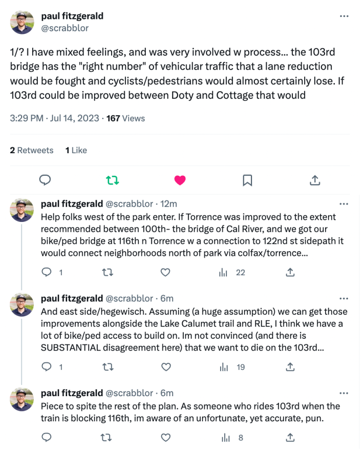
Update 7/14/23, 2:40 PM: Read Friends of Big Marsh executive director Paul Fitzgerald’s thread in response to this article on Twitter: “I have mixed feelings…”
Friends of Big Marsh recently shared the East Side Neighborhood Connectivity Plan, a study of local bike and pedestrian infrastructure that the group was able to get funded with support from Cook County’s Invest in Cook program and help from Audubon Great Lakes. The report recommends several walking and biking improvements to the area surrounding the park, a nearly 300-acre natural area on the far Southeast Side of Chicago. Check out the entire report online here.
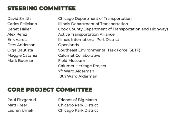
The document’s creation involved a steering committee and core project committee of representatives from state and city agencies and ward offices, as well as advocacy groups and cultural institutions. The report was prepared by the engineering firm Epstein.
Big Marsh Park is a nature and visitor refuge that houses a destination bike park with single-track, multi-use trails, and three jump lines for BMX and dirt jumping fans. But, ironically, it’s difficult to access via bicycle or foot.
The park is bounded by the Norfolk Southern railroad line on the east, with Lake Calumet and the Bishop Ford Freeway on the west. Its only entrance is located on the west side of the park, on Stony Island Avenue near 116th Street. The entrance is roughly 2.5 miles from the closest residential block. The stretch of Stony Island leading to the entrance has paint-only buffered bike lanes, but they don’t connect with any other low-stress bike routes, terminating at unmarked 122nd Street to the south and high-speed, five-lane 103rd Street to the north. On top of that, the stretch of Stony Island bordering Lake Calumet and Big Marsh is secluded from view and free of cross-traffic, making it a popular spot for dangerous and illegal drag racing.
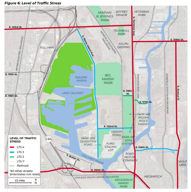
The East Side Neighborhood Connectivity Plan recommends a second entrance to Big Marsh on the east side of the park at 116th Street, along with a pedestrian and bike bridge spanning the railroad tracks. Paving 116th, currently a dirt road, is also recommended, making it a route to connect with Torrence Avenue, the next major north-south street east of the park. Installation of bike/ped side paths and two-way separated bike lanes are proposed for Torrence, along with connecting east-west bike lanes on 122nd and a trail along the north bank of the Calumet River.
Safety improvements are also recommended for Stony Island Avenue: narrowing the road to allow space to construct a side path on the east side of the road, running alongside Big Marsh. The report recommends separated bike lanes and side paths on 103rd, as well as closing gaps in the sidewalk.
These recommendation align with new local bicycle routes planned by other organizations, including a new trail across Lake Calumet to connect Big Marsh with neighborhoods west of the lake, and a side path on 130th Street, connecting with the Major Taylor Trail. All these improvements would add up to safer and more convenient bicycle and pedestrian access to Big Marsh, especially for people in the surrounding neighborhoods of Jeffrey Manor, Trumbull Park, South Deering, Veterans Park, Pullman and Hegewisch.
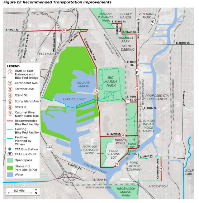
However, the new study’s proposed changes, broken into seven separately fundable chunks, don’t form a loop or grid but rather a “U” shape, leaving an east-west safety gap directly north of the park on 103rd between Stony Island and Oglesby avenues. Under the new plan, neighborhoods would have bike routes to Big Marsh Park, but not necessarily to each other.
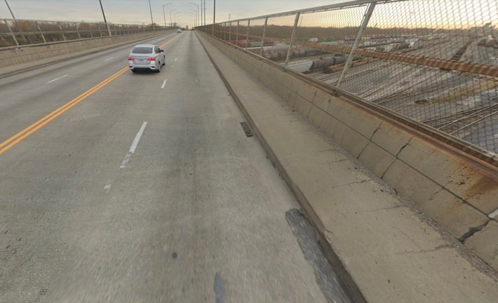
The safety gap can be blamed on the bicycle-hostile 103rd Street bridge, which traverses a thick cord of Norfolk Southern train lines. The four-lane bridge has no bike lanes and no shoulder, with narrow sidewalks on the north and south sides. Heavy traffic, much of it large trucks, crosses the bridge daily.
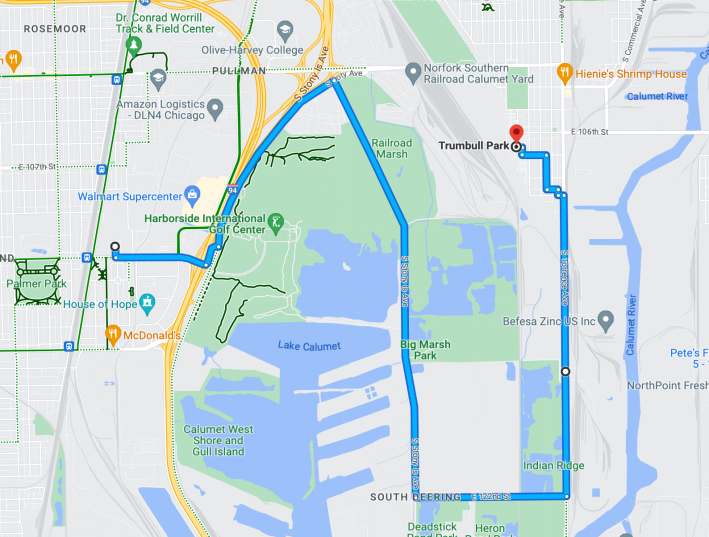
In an email discussion after the report was shared, South Side bike advocates voiced frustration that the Illinois Department of Transportation, which has jurisdiction over 103rd Street and was on the steering committee for the new report, appears to have vetoed the inclusion of safety improvements to that stretch of 103rd in the proposal. That means, for example, that if you want to bike safely from the Trumbull Park neighborhood (located just south of 103rd/Oglesby) to the Pullman National Historic Monument, instead of being able to safely ride there on 103rd, at least until the Lake Calumet bridge is built, you’d have to detour for miles. You’d go south on Torrence to 122nd, head northwest on Stony Island almost to 130th, ride southwest on Doty Avenue, and then go west on 111th Street to Pullman. Considering that this document is called “East Side Neighborhood Connectivity Plan,” that’s a reasonable critique.
The study was intended to court political will and funding for the construction of any or all seven pieces of the proposal. While the plan isn’t perfect, it’s a first step toward better biking and walking infrastructure in one of the most car-centric parts of the city. If it moves forward, hopefully the plan will include a solution to make 103rd Street friendlier to all road users.
Check out the East Side Neighborhood Connectivity Plan here.

Did you appreciate this post? Please consider making a tax-deductible donation.

Streetsblog has migrated to a new comment system. New commenters can register directly in the comments section of any article. Returning commenters: your previous comments and display name have been preserved, but you'll need to reclaim your account by clicking "Forgot your password?" on the sign-in form, entering your email, and following the verification link to set a new password — this is required because passwords could not be carried over during the migration. For questions, contact tips@streetsblog.org.