47th Ward bike-ped infra night celebrates progress inspite of bureaucratic headwinds
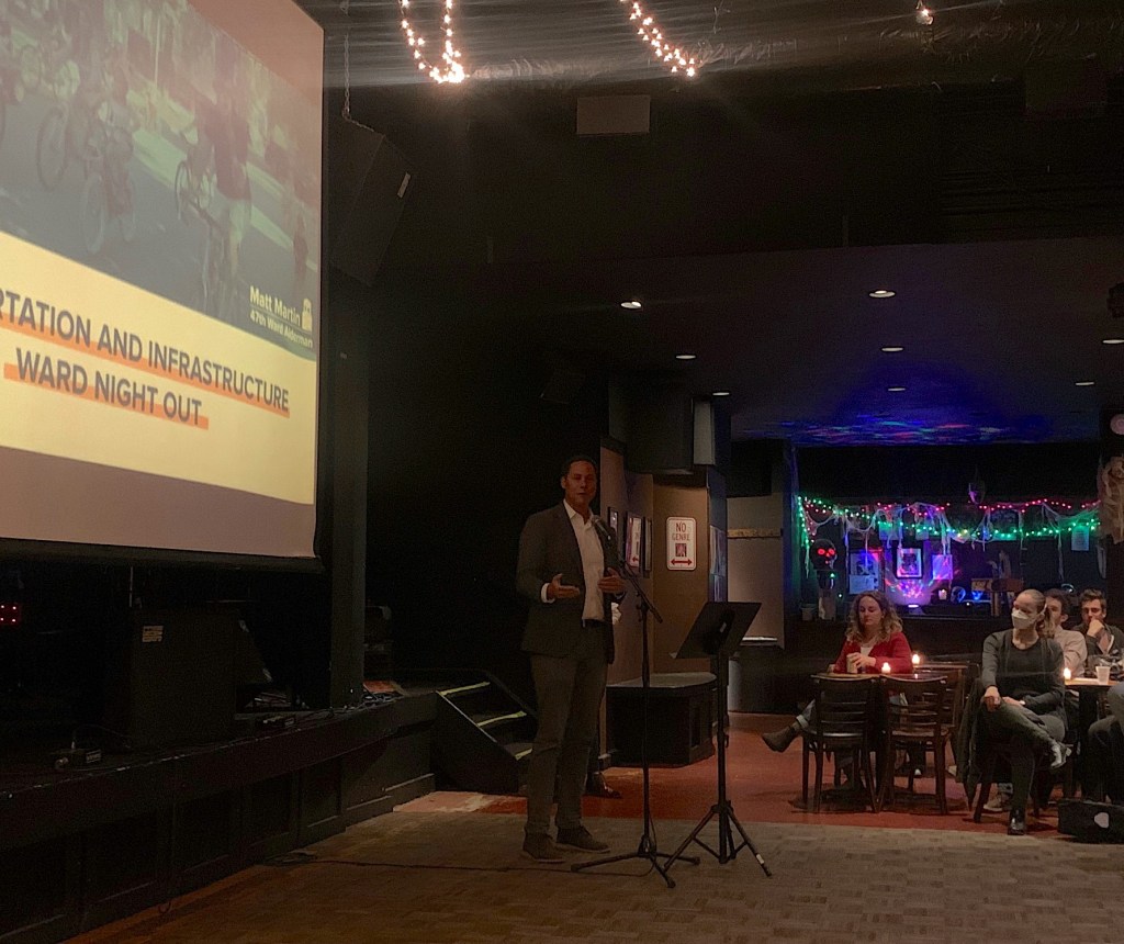
Last Thursday evening Ald. Matt Martin (47th) held a Transportation and Infrastructure Ward Night Out at Martyr’s, a music venue at 3855 N. Lincoln Ave. in North Center. Martin has been a vocal advocate for pedestrian and biking infrastructure improvements within and beyond the boundaries of his ward since he was elected in 2018. Martin proposed downtown congestion pricing at the city’s 2021 budget talk. He was the first alderman to bring a traffic-calmed Slow Street to his ward. And in June, after Peter Paquette, a 75-year-old ward volunteer, was killed by a distracted driver while crossing Irving Park Road in a marked crosswalk at Hoyne Avenue, Martin penned an op ed in the Sun-Times listing things the Illinois Department of Transportation can and should do to improve safety on state-controlled roads like Irving Park.
About 30 people showed up Thursday for a presentation on recent bike-ped improvements made under Martin’s watch, and upcoming projects in the ward. (A similar event last month at Begyle Brewing drew more than 100 people.) Transit advocacy nonprofit Better Streets Chicago (cofounded by Streetsblog Chicago co-editor Courtney Cobbs) had an info table set up next to check in. The difficulties of improving safety on roads owned by the county or state was a recurring theme of the evening.
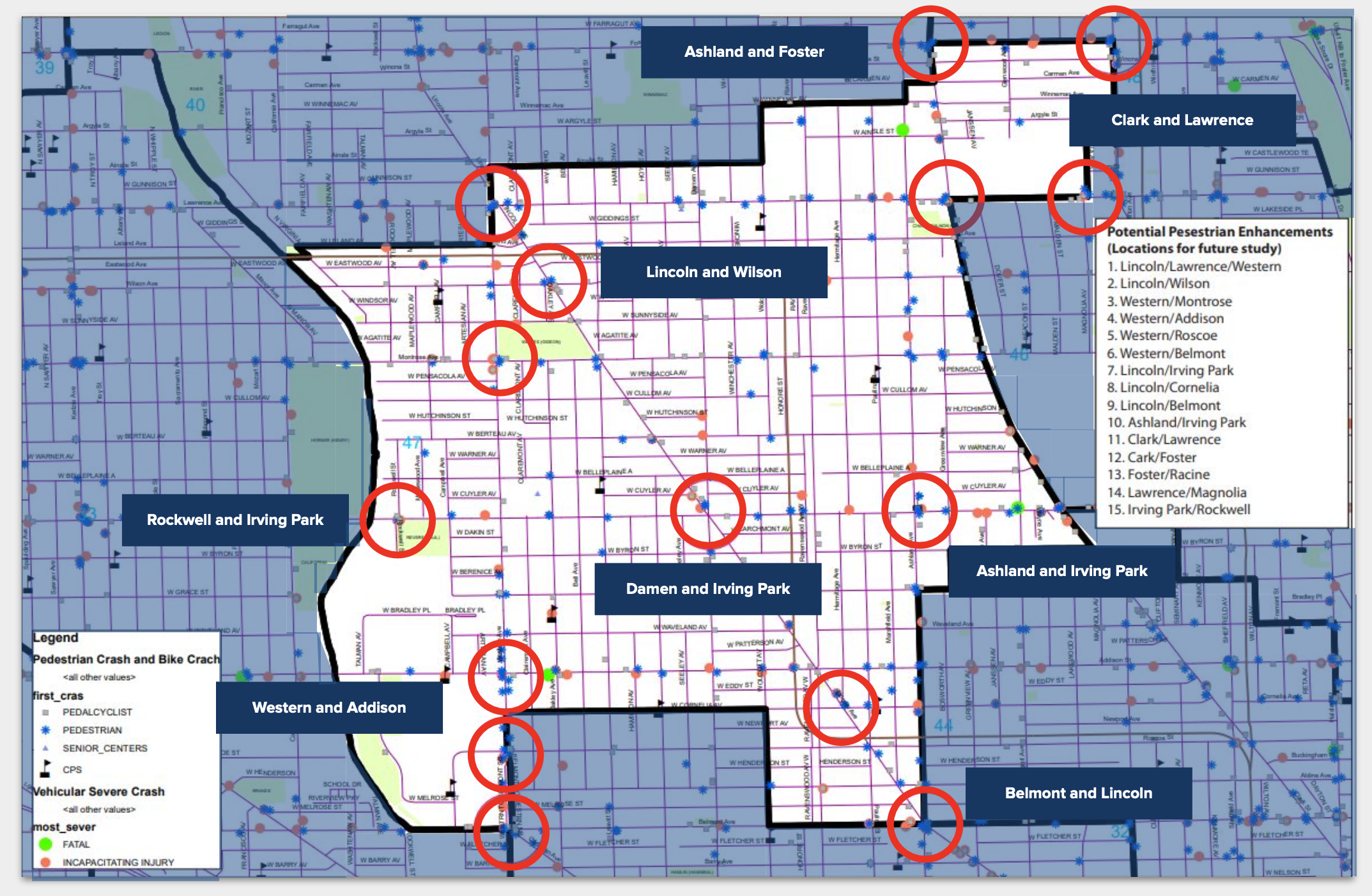
The first slide was a map of 14 high-crash zones in the 47th Ward, most of which are at intersections along Lincoln, Ashland and Western avenues – all streets controlled by entities outside the city and subject to differing sets of regulations and design codes. “It’s a weird situation where some of the streets we have the most challenges, not coincidentally, are the streets that have the most government bureaucracy,” Martin said. “But we try not to let that deter us.”
The crisscrossing of city-, state-, or county-controlled roads in Chicago creates a knot of red tape that too often suffocates sensible safety measures. One example: Josh Mark, the ward’s director of development and infrastructure, pointed to a proposal for a pedestrian island on Irving Park at Bell Avenue, an intersection close to Coonley Elementary and St. Benedict prep school. The idea was shot down by IDOT because the island would prevent the driver of a 60-foot truck from turning off Bell onto Irving Park. This reasoning is absurd: Dozens of pedestrians, many of them children, would benefit from the pedestrian island each day, while a semi drivers probably rarely – if ever –need to travel down a one-way residential street like Bell. Yet a set of guidelines that apply to both rural, suburban, and urban areas keep high-crash corridors like this unchanged. Mark said of IDOT, “They’re not used to having roads where pedestrians exist. One of their criteria is, ‘Is there a need for pedestrian safety?’”
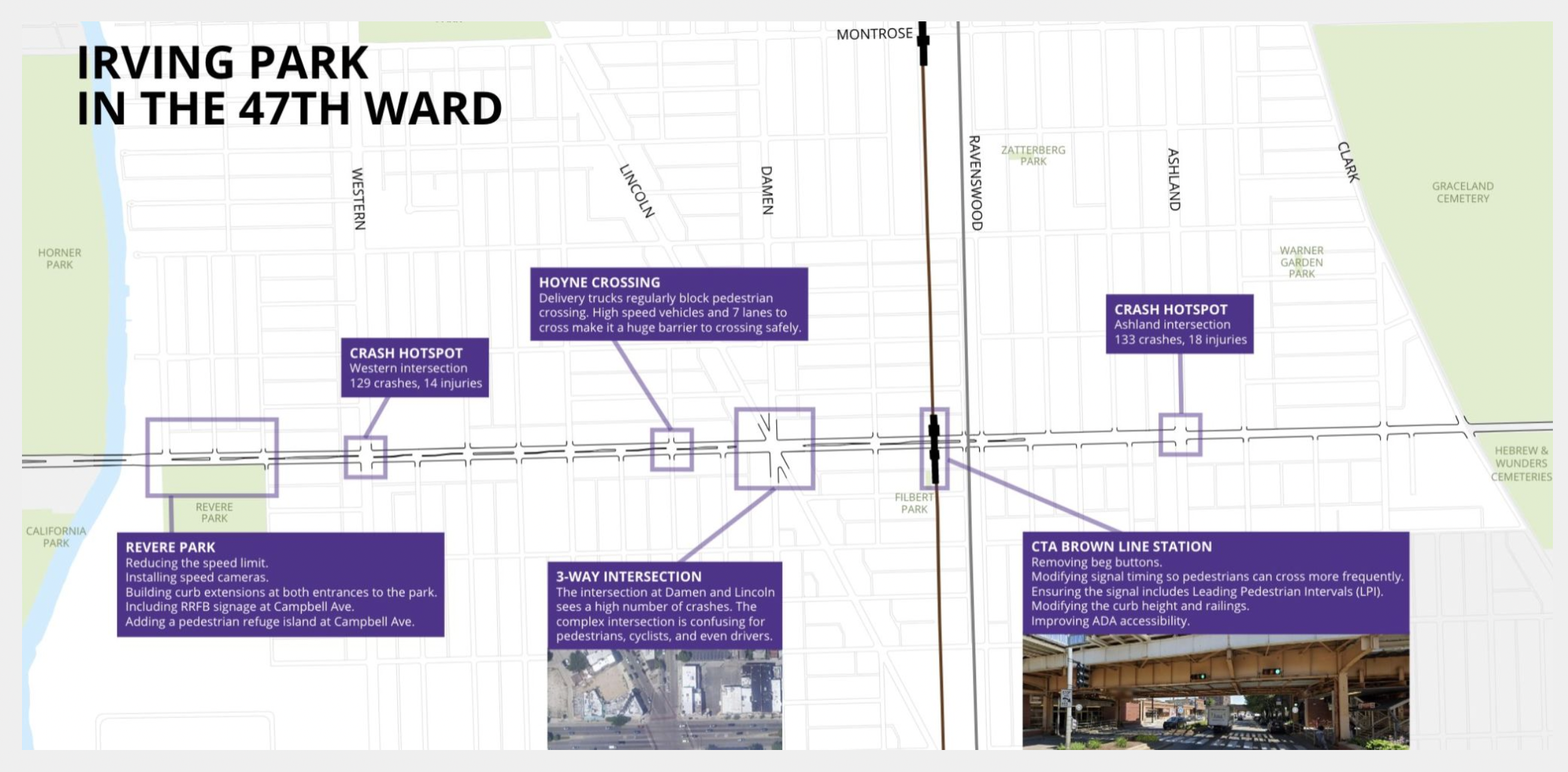
However, Mark said that Martin’s office is continuing to push IDOT, the Chicago Department of Transportation, and state representatives for safety improvements, including some that were previously rejected. The 2019 resurfacing of Irving Park from the north branch of the Chicago River to Ravenswood Avenue was celebrated as a community-driven win. With the help of volunteers, Martin’s office wrote a planning document with traffic-calming recommendations that could be incorporated in the project at low cost. The result: Nineteen new curb extensions that slow down turning drivers and shorten the crossing distance for pedestrians.
Martin has proposed the city adopt a Complete Streets ordinance, requiring CDOT to include bike-ped safety improvements in all road resurfacing and reconstruction projects. Such a requirement would not only reduce the need for residents and alders to advocate for including safety improvements in projects like the Irving Park resurfacing, but also reduce costs by eliminating the need to retrofit corridors with safety infrastructure later. Currently there is no such requirement, nor is there enough coordination between CDOT and other city departments that do construction projects on roads, like the Water Management and Streets and Sanitation departments.
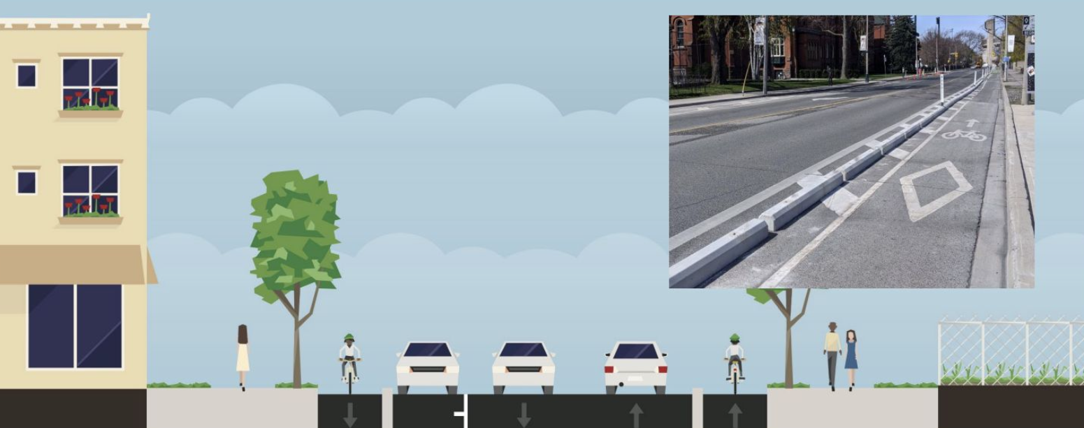
Recent and upcoming bike lane construction was also discussed. Mark announced, to applause, the installation of a concrete curb protected bike lane on Clark Street between Irving Park and Montrose Avenue. In the next breath, he expressed frustration that bike lane planning and construction remains subject to aldermanic privilege, the ability of Council members to veto projects in their wards. Seen from above, Chicago’s patchwork of bike lanes is a map of the priorities and budget constraints of fifty different alderpersons. On the ground, it means a cyclist will find themself in a protected bike lane one moment, only for it to disappear when they cross a street.
Mark noted that the long awaited, bi-directional Leland Avenue Neighborhood Greenway route will be a product of collaboration between Martin and 40th Ward alder Andre Vasquez. “We can’t tell any wards what to do. We’re just lucky to be on good terms with our neighbors and our neighbors happen to not hate bikes,” Mark said. “I can name aldermen who hate bikes. And some aldermen don’t care so much and, when they have a limited budget, [bike infrastructure] may not be a priority. We see bike lane work as something that needs to happen citywide.”
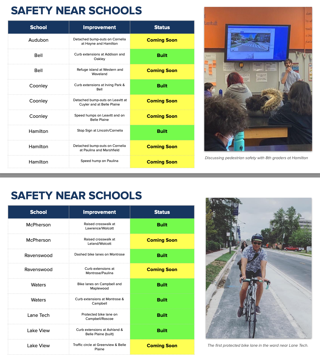
Martin also highlighted safety improvements in the last year around schools and senior centers – a programmatic use of some of the ward’s $1.5M in ward “menu money.” Two slides listed recently built and soon-to-come curb extensions, refuge islands, stop signs and other traffic-calming measures near Audubon, Bell, Coonley, and Hamilton schools and Northcenter and Bethany Methodist senior centers.
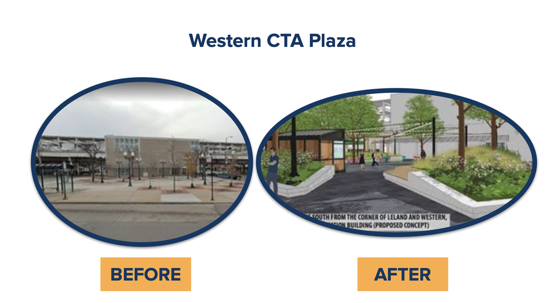
Finally, Mark went through a short list of upcoming projects, most notably the $30M redesign and rehabilitation of the Western Brown Line station. Renderings showed the transformation of the adjacent plaza from a concrete expanse with a checkerboard of small trees and lampposts into a welcoming space with lush planters and fabric shades. Leland Avenue between Western and Lincoln will be raised to slow traffic and create flexible space. Mark said the revitalized plaza would be the site of farmers markets and festivals in the summer and reserved for parking in the off-season. The ward secured $8M from the city for the project, which unlocked $22M of matching federal funds. Mark said the project is slated for completion in about two years.
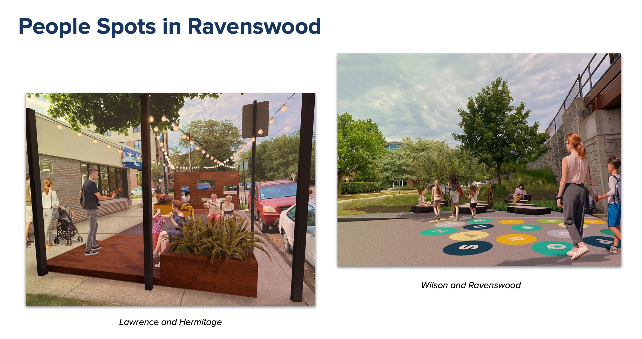
Other upcoming projects in the ward include several “people spots” – welcoming public spaces with seating, planters, lighting and other cheerful design elements—being built in collaboration with Greater Ravenswood Chamber of Commerce. Two are currently under construction – one at Lawrence and Hermitage near Jersey Mike’s Subs and one at Wilson and Ravenswood. Future people spots include Montrose and Winchester and Leland and Damen, across from Perfect Cup coffee shop. “The idea is to enhance their space and make it comfortable for folks who want to patronize their local businesses,” Mark said.
The presentation was followed by an hour of time for one-on-one conversation with Martin and Mark. The evening was informative, not only about bike and pedestrian infrastructure progress in the 47th Ward, but on just how hard it is to bring these projects to fruition.

Streetsblog has migrated to a new comment system. New commenters can register directly in the comments section of any article. Returning commenters: your previous comments and display name have been preserved, but you'll need to reclaim your account by clicking "Forgot your password?" on the sign-in form, entering your email, and following the verification link to set a new password — this is required because passwords could not be carried over during the migration. For questions, contact tips@streetsblog.org.