New bike lane plan for Belmont and Kedzie still falls short
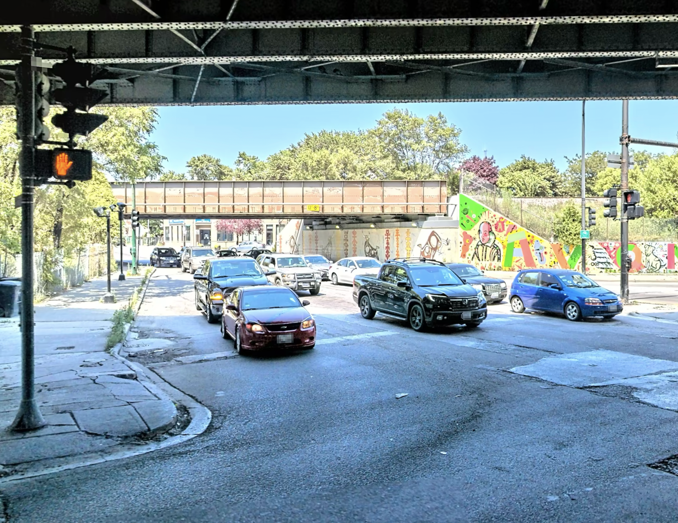
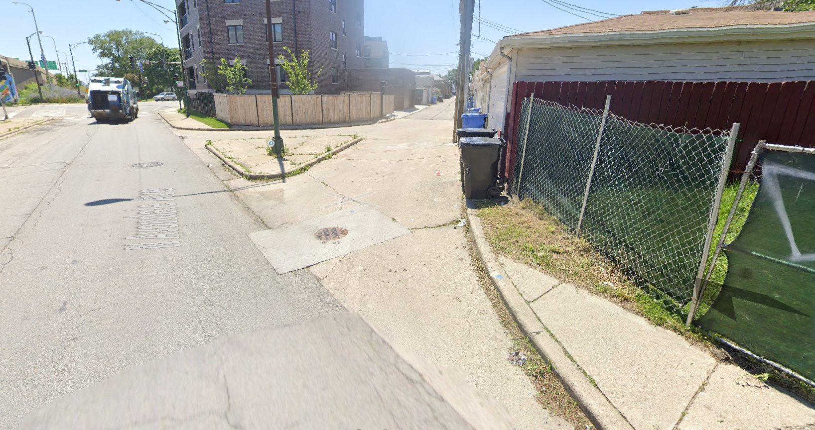
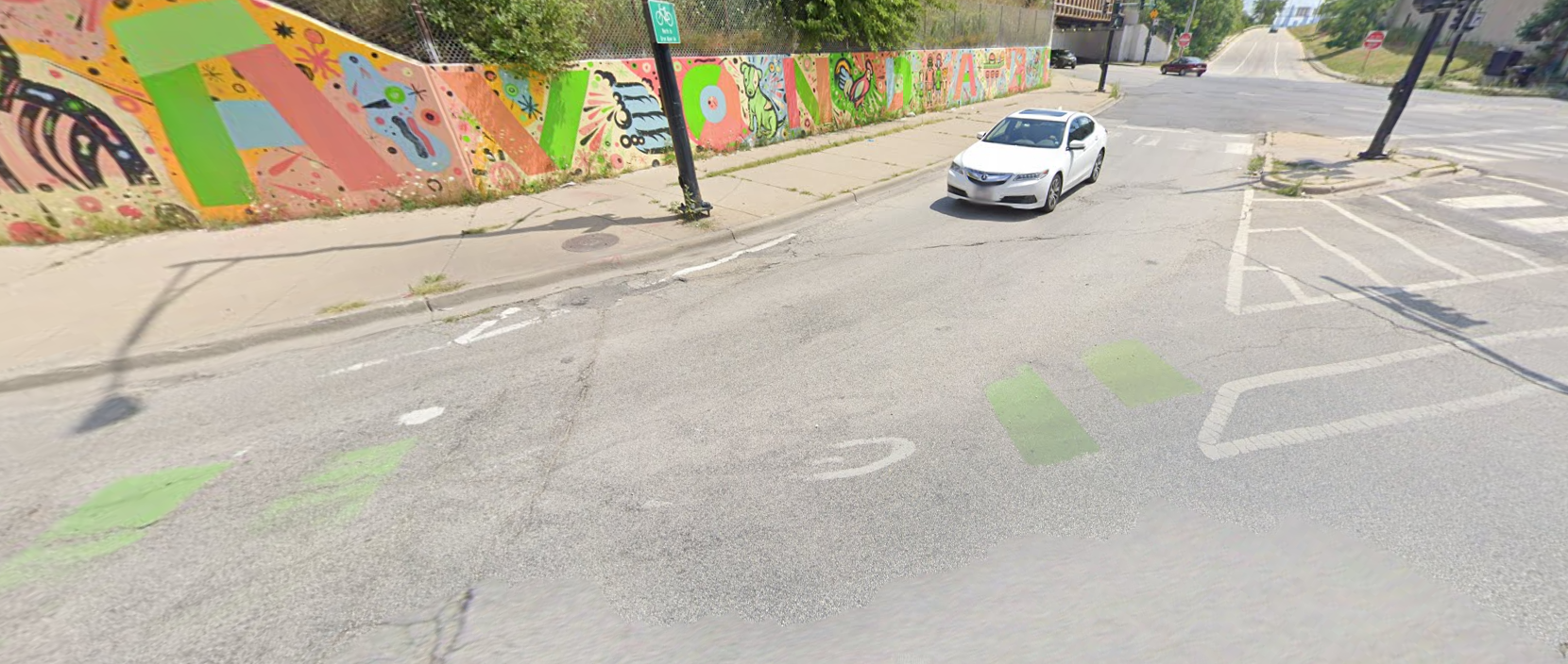
Apple Maps street view of one side of the Kedzie-Belmont intersection showing the lack of room for cycling and deplorable sidewalk conditions.
At the first meeting of the new Chicago Mobility Collaborative on June 30, the Chicago Department of Transportation briefly presented a new plan for the Belmont and Kedzie intersection. This is a complicated intersection, involving both grid and diagonal streets, an expressway exit and support columns, plus existing and new bike lanes.
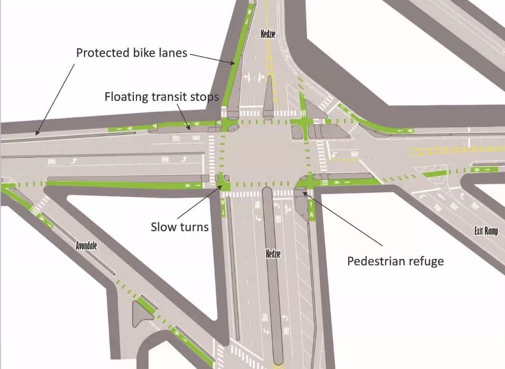
Just a few weeks ago, in early June, Alderperson Carlos Ramirez-Rosa and CDOT presented an earlier plan for this intersection, which would have only included only two corners of protection as well as unprotected bike lanes on Kedzie.
The new plan for this intersection represents a huge improvement over current conditions and the previous plan: we see protected bike lanes on both Belmont and Kedzie and four corner refuge islands (a key part of protected intersection design best practices in the Netherlands). There are also bus boarding islands (or floating bus stops) recently discussed on Streetsblog Chicago, and curb protection on the Kedzie bike lanes. Lots of good stuff going on here!
While this plan is better, there are some missed opportunities to incorporate more protected intersection elements suggested by NACTO, of which Chicago is a founding member.
Here are six suggestions to improve the design, counterclockwise from the upper left. (We will assume for this discussion that it is not possible to eliminate the slip lane fed by the Kennedy Expressway exit.)
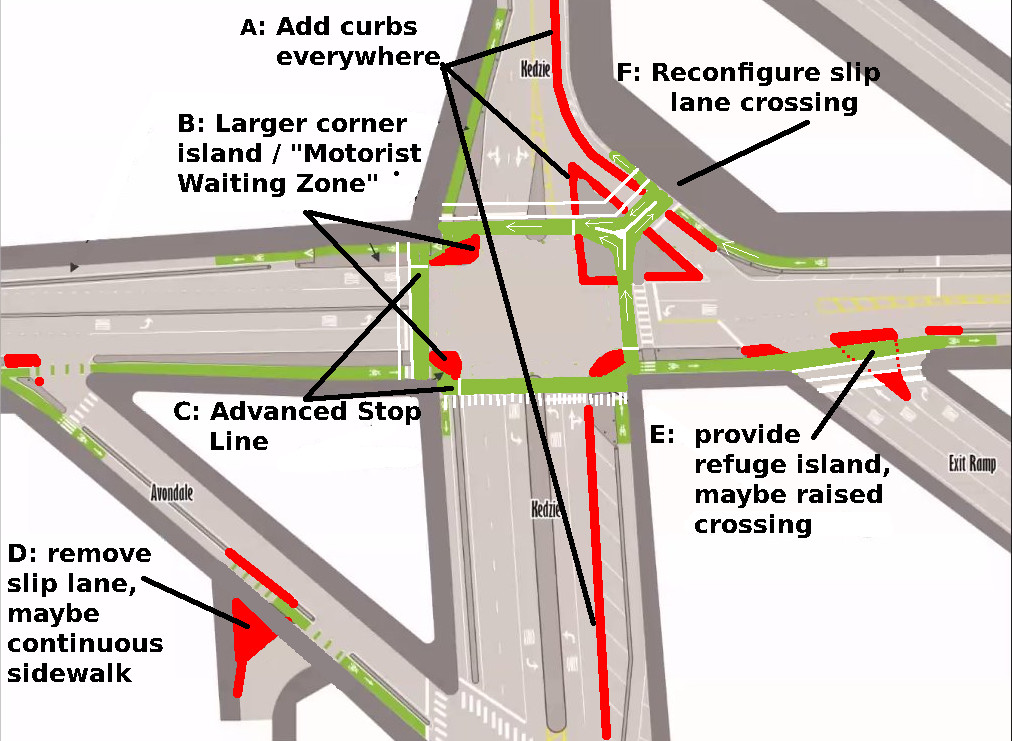
A: Add curbs everywhere. Too many places in this design rely on paint alone to tell drivers where not to go. The curved bike path along the slip lane is particularly likely to see vehicle incursions.
B: Larger corner island / Motorist Waiting Zone. In most places, the cycle lane should jog to the right to allow for a larger corner refuge island and more of a 90 degree interaction between turning drivers and cyclists proceeding straight. This is nice in places where the bike lane is already separated from the traffic lane by a lane of parking, and pretty much necessary if the bike lane is right next to the main traffic lane separated only by a narrow curb. (The crosswalks and motorist stop line have to move as well, usually only about 5 feet.)
NACTO calls this the “Bikeway setback” or “Motorist Waiting Zone”, which “provide a place for motor vehicle drivers to wait before turning across the bike’s path of travel….larger setbacks provide better visibility and give people bicycling more time to notice and react to turning vehicles.”
C: An “Advanced Stop Line” or “Bike Queue Area” is a key piece of protected intersection design. The “stop line” for bicyclists before the crosswalk should be moved all the way to where the bike lane meets the cross street. (Cyclists would have to yield to any pedestrians in the crosswalk, of course.)
The advanced stop line offers two big safety advantages in the situation where both a cyclist and driver are waiting at a red light and the driver wants to turn right:
(1) Because the waiting cyclist is so far in front of the waiting driver, they should be visible through the windshield, well before either of them start moving, increasing situational awareness.
(2) When the light turns green, the cyclist has a 20- to 30-foot head start and can usually make it all the way across the car lane before the turning driver even crosses the cycle lane, eliminating the possibility the driver will fail to yield.
D: Remove Slip Lane (at alley). This is a minor piece of the plan, but is a good place to demonstrate better urban street design. We do not need a slip lane for side streets, let alone for an alley! Twist the alley for 90 degree interaction and to slow down cars and trucks entering or exiting the alley. This would also be a great place to pilot a continuous sidewalk and bike lane!
E: Provide a refuge island, maybe a raised crossing. Where an expressway exit transitions to a city street is a dangerous spot for pedestrians and cyclists, because drivers are often going fast and not prepared for non-car road users. There is no danger of getting hooked by a turning car here, but there is a significant danger presented by drivers overshooting the stop line or turning right on red. At minimum, the refuge island here should be hardened with concrete to slow drivers down and shorten crossing distance.
Additionally, a gentle raised crossing here—one that would be comfortable at 25mph but not at 45mph—would encourage drivers to slow to an appropriate city speed, even when they have a green light.
Right turn on red should also be prohibited at this intersection—as it should at any intersection with a bike lane—and enforcement by camera, used in Washington, DC, should be considered if compliance is low.
F: Reconfigure slip lane crossing. A short two-way section of bike lane here—at right angles to the slip lane—eliminates two dangerous crossings. Without this modification, drivers would have to cross two bike lanes at shallow angles—one before the stop line, and one significantly after the stop line when they are focussed on merging.
With this new arrangement, northbound and westbound cyclists have a short crossing distance at right angles, protected by a traffic signal. If the bike lane gets busy and more room is needed for queueing cyclists, the slip lane can be shifted southwest (making the triangle island smaller) to make room, or the 13-foot sidewalk could be narrowed by a few feet.
Challenges, but opportunity
The intersection for Belmont and Kedzie is a challenge: it is complicated by existing north-south bike lanes, a slip lane and exit lane from the expressway, and bus stops. It might not be possible to copy-and-paste a Dutch-style intersection at this location, but it is possible to incorporate more NACTO-approved elements of protected intersection design, such as advanced stop lines, more curb protection, and better interaction with the slip lane (if it remains at all).
Let’s do one more revision of this intersection before we lock it in with concrete for the next couple of decades.
Stay in touch
Sign up for our free newsletter
More from Streetsblog Chicago
Which Metra corridor would become more bike-friendly and greener under a new plan? Ravenswood!
Thanks to plans to convert little-used parking spaces, the avenue is slated to get a new bike lane, and the Winnslie Parkway path and garden will be extended south.


They can drive 25: At committee meeting residents, panelist support lowering Chicago’s default speed limit
While there's no ordinance yet, the next steps are to draft one, take a committee vote and, if it passes, put it before the full City Council.
One agency to rule them all: Advocates are cautiously optimistic about proposed bill to combine the 4 Chicago area transit bureaus
The Active Transportation Alliance, Commuters Take Action, and Equiticity weigh in on the proposed legislation.