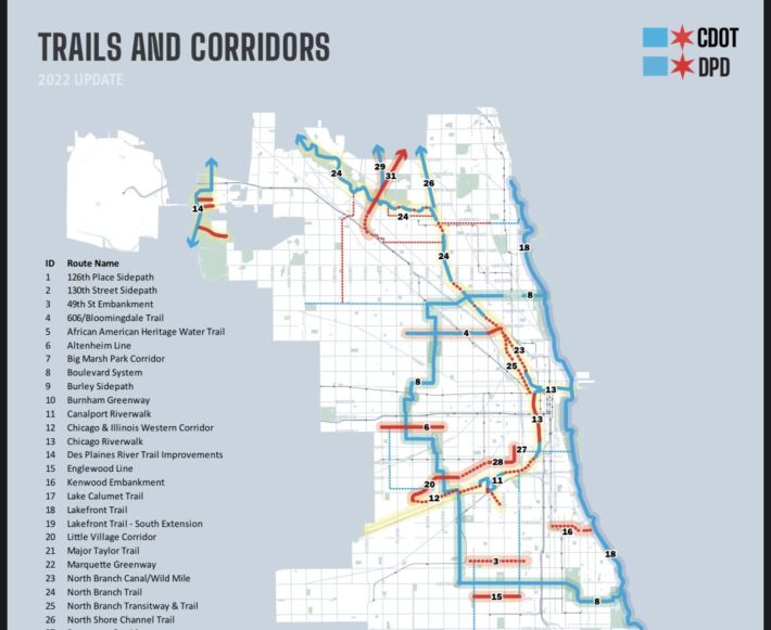
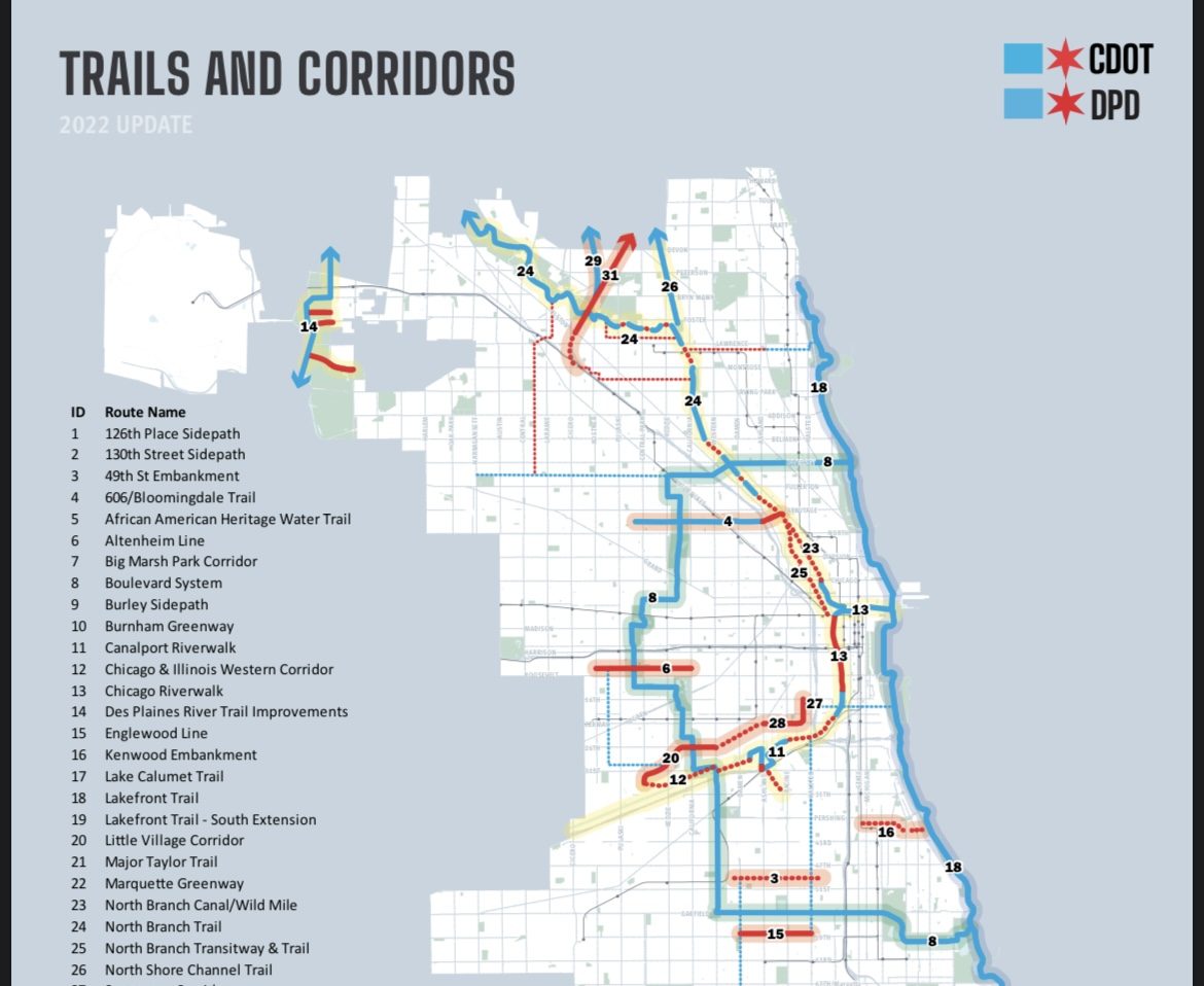
Yesterday, Chicago Department of Transportation Commissioner, Gia Biagi, announced in a speech to the City Club of Chicago a new "vision" for trails and parks within the city. A press release regarding the trails explains that some will be new, some will be extended, and others will be maintained, and that the "trails and open spaces will contribute to a network of community-led green infrastructure projects that promote the health and well-being of Chicago residents and visitors." In a period of rising transportation costs for drivers and a rise in traffic deaths, the announcement seems out of touch.
Mayor Lightfoot stated in the press release that the “expansion of trails and open spaces is sorely needed across our neighborhoods to benefit existing residents and for the city to achieve health, economic, climate, and transportation goals. This vision and investment also positions Chicago well to receive federal funding to complete many of these projects over the coming years.”
The city plans to create 48 miles of new trails for commuting and recreation – some of these miles comprise a floating boardwalk, extend the Riverwalk, or are for kayaking and canoeing. The individual projects will be "spearheaded locally with planning support from the Department of Planning & Development, CDOT, and the Chicago Park District". The city says they will be working "closely with community stakeholders" and apply for federal funding.
Commissioner Biagi stated in the press release that "trails and parks are key to meeting many CDOT’s Strategic Plan goals around mobility…. This vision will also greatly enhance the biking and pedestrian experience in Chicago as we invest in on-and off-street connections that create a seamless network around our city that is connected by our historic boulevard system."
The city and its sister agencies will be investing $15 million, some of which is already allocated. I think it's important to see this as a parks plan, and not a bike path plan, as some of the projects included do not add what we might collectively consider a way for biking between places. Some of the projects include:
- Englewood Nature Trail: "City agencies will continue working with local stakeholders to complete a framework plan and start phase 1 design for a linear park along the one and a half mile 59th St. rail embankment, funded in part by $6 million in local funds pending federal assistance."
- North Branch parks: "The Park District will continue to allocate up to $7 million in approved financing for waterfront and trail improvements near the confluence of the North Branch and North Branch Channel, specifically at Ronan Park, Kiwanis Park, Legion Park, and River Park."
- El Paseo: This trail is conspicuously absent from the list in the press release, but it exists on the map as three segments: Sangamon, Cermak, and Little Village Corridors. The design process is moving slowly as there is a concern the neighborhoods will experience housing price increases during and after the construction of The 606. Planning Commissioner Cox alluded to this in the press release, saying, "We will ensure that community needs are front and center of these investments and that we put guardrails in place to curb gentrification forces."
- African American Heritage Trail: This is a water-based route on the Little Calumet River for kayaking and canoeing.
However, The Daily Line reported on additional complications with the El Paseo planning.
Ald. Byron Sigcho-Lopez (25) told The Daily Line there was a “federal grant [to analyze]… the feasibility of the [El Paseo] trail.” But the alderman charged Lightfoot’s administration with continuing to “fast-track heavy Industry along the same pathway where we’re going to propose a bike lane.”
The alderman said he thinks “that these contradictions have gotten to the point that the Paseo project seems to be on hold” so community leaders are now proposing that the city consider 16th Street in Pilsen as an “alternative for a pedestrian and bike friendly area.”
Not everything was about infrastructure, though. In the 26-mile Chicago Boulevards System, "CDOT will reopen its Open Boulevard program in the summer of 2022 to reallocate street space for community events."
If you regularly bike in Chicago and you ride on or cross some of the streets in the boulevard system, you may see the map that was shared during the announcement and wonder "why is the boulevard system shown under the 'maintain and improve' category when the vast majority of the length of the system has no bikeway?"
Part of the reason that there are no specific proposals to make the boulevards safe for walking and biking is that City Hall wants to use the "Open Boulevard" summer events to drum up resident interest in improving the section of the boulevard where they live.
[You can find a full list of projects in the Mayor's press release]

The trails vision was unofficially announced in tandem with Mayor's Lightfoot proposal to provide gas cards and transit fare relief.
Better attention must be paid to on-street bikeways – the connections to the trails. I wonder if the funds and resources for trail planning and creation would be better utilized to create 50 miles of on-street facilities that can help connect residents to grocery stores, community centers, libraries, daycare, schools, employment centers etc. especially given the stated goals to help the city meet its transportation and climate goals. I do not think that the residents of Chicago are that much different than the majority of Americans who want an alternative to driving. It is my opinion that on-street facilities would provide a meaningful alternative to driving.
In her City Club speech, Commissioner Biagi touted 125 miles of new bike lanes installed since 2020. We appreciate every single foot of new bike lanes, but their quality is not made equal. For example, the Clark Street bike lanes in Edgewater have been constantly blocked and parked in every day I've tried to ride in them. It should be better when concrete separation is built in the spring, but even then cyclists see drivers using curb-separated bike lanes. Pavement quality issues are also persistent across Chicago.

It might be easier to create trails that do not interfere with car dominance on our streets without the conflict that arises from the perceived imposition on drivers when street space is reallocated. The lack of challenge to car dominance in this vision leaves me disappointed. I want to see a commitment from CDOT to quickly remedy issues when people who bike bring them up. One avenue for that, the Mayor's Bicycle Advisory Council, hasn't met in over two years. CDOT hinted at a new communication outlet in a tweet on Friday (presumably it's not an April Fool's joke).
In honor of #GoodNewsFriday, we’re excited to be convening a new committee that will bring together intersectional thinking 🤔 about safe transportation - walking,biking,transit , accessibility,& engagement.#VisionZero #VisionZeroChicago #ChicagoDOT #ChicagoSAFE #yourCDOT pic.twitter.com/agat5vjDBO
— CDOT (@ChicagoDOT) April 1, 2022
We are already far off-course when it comes to completing the Streets for Cycling 2020 plan and I'm doubtful all of the trails announced will be completed given the city's affinity for creating plans that sit on shelves.
Another element that leaves me skeptical of this plan is the map's misleading nature. Diversey Boulevard between the lakefront and Elston Avenue is a designated bike route, but it has no bike lanes or space for cycling. Even as a confident rider I don't feel comfortable biking Diversey, so seeing Diversey designated as a "trail" is deceiving.
As Streetsblog Chicago recently editorialized, there is a lot of room for the city of Chicago to invest in projects that will provide a viable alternative to driving, something that will offer long-term savings to many individuals and families transportation budgets and improve our city for the better on a variety of levels and sadly I don't think this trail vision will provide that.


