Neighbors give a thumbs-up to Leland Greenway plan, including possible raised bike lane
At last night’s virtual meeting on the long-awaited Leland Avenue Neighborhood Greenway in Lincoln Square and Ravenswood, city officials unveiled new designs for the long-awaited bikeway, which could include a segment of concrete-protected and/or raised bike lanes. At the start of the event there were over 100 members of the public in attendance. The last public hearing on the greenway was in September 2019 and was refreshingly uncontroversial according to Streetsblog Chicago co-editor John Greenfield. I am happy to report that this meeting followed the same pattern.
Construction of the greenway is expected to start this summer or fall. The work will be coordinated with the Western Brown Line station plaza project, a colorful overhaul of what’s now a drab, underused public space.
Chicago Department of Transportation bike and pedestrian program manager David Smith led the meeting, which was attended by local aldermen Andre Vasquez (40th ward) and Matt Martin (47th ward), plus Lincoln Square-Ravenswood Chamber of Commerce executive director Rudy Flores. Flores opened the hearing by stating that the Neighborhood Greenway project is aligned with Chicago’s Vision Zero crash prevention goals and will increase access to the Lincoln Square area.
Smith stated that the CDOT team has received overall positive feedback about the Leland Greenway, and that the project is intended to legalize and organize cycling behavior that is already happening on Leland Avenue (4700 North) such as contraflow westbound cycling on the stretch of Leland between Clark Street (1400 West) and Damen Avenue (2000 West.) The Department also recognizes that many people with children who travel this corridor wanted a safer route to be able to bike with their children or perhaps allow for independent cycling. With that in mind, the department sought to create a “family friendly” design that creates a more comfortable cycling experience “for people of all ages and abilities.”
Before the officials got into the nitty-gritty of the greenway design, they informed attendees that bike-friendly streetscape changes are coming to Lawrence Avenue (4800 North) and Francisco Avenue (2830 West, near the east bank of the Chicago River.)
This initiative builds on other recent streetscape changes on Lawrence. New painted bike lanes on Francisco, which is one-way southbound, will help connect riders to the North Shore Channel Trail. New crossings will be marked for people walking and biking. Construction is slated to start this year.
The plan for the Leland Greenway between Clark and Damen is similar to most other existing Chicago Neighborhood Greenways. Contraflow (“wrong-way”) bike lanes will facilitate westbound cycling. There will be some traffic calming in the form of speed humps, high-visibility crosswalks, curb extensions. And the posted speed limit will be lowered to 20 mph.
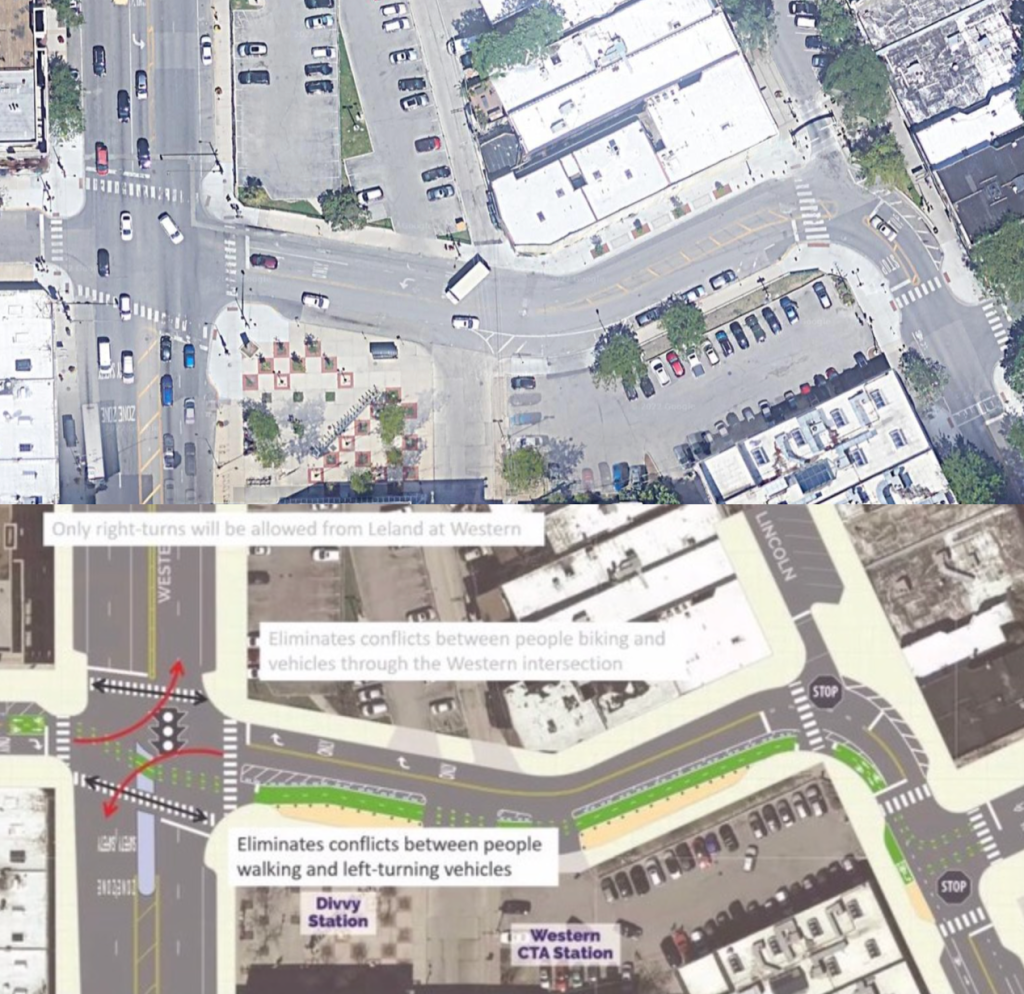
But the Leland Greenway takes a bit of a departure from the other Neighborhood Greenway designs at the Leland and Western Avenue (2400 West) intersection, with design that’s intended to reduce cut-through traffic. David Smith said local residents want less cut-through traffic on Leland west of Western, specifically on the one-way eastbound stretch between Virginia Avenue (2730 West, near the east bank of the river) and Western.
CDOT responded to this request with a plan to prohibit left turns from Leland onto Western for both eastbound and westbound drivers. Removing the left turn lane for westbound motorists will help make room for a new two-way protected bike lane on Leland between Western and Lincoln Avenue. A pedestrian island will be installed in the south leg of Leland/Western, making it easier to walk to the Western Brown Line station at the southeast corner of the intersection.
CDOT did traffic counts at the Leland/Western intersection and observed that only 4 percent of westbound drivers on Leland are making left turns onto Western during the AM peak traffic hour (the busiest of the two hours between 7 and 9 a.m.)
During the PM peak hour (the busiest of the two hours between 4 and 6 p.m.), CDOT found that 9 percent of drivers were making that move.
Attendees shared concerns that drivers may not follow the new rule that prevents left turns. David Smith responded that CDOT’s Safety Ambassadors can come out and educate drivers about the turn ban, adding the physical design of the intersection should make it clear to drivers that left turns are not allowed.
It’s true some people driving west on Leland may still be unaware of the left-turn prohibition, or make a conscious decision to ignore it. And the removal of the westbound left-turn lane means it’s technically possible that, if those folks have to wait for a gap in eastbound traffic on Leland before executing the (illegal) left turn, other motorists behind them will have to wait until the left-turners are out of the way before turning right onto Western.
However, only 1/13 of westbound motorists are currently making a left turn during the peak AM hour, and less than 1/7 are doing it doing it during the peak PM hour. Therefore, the subset of those drivers who are ignorant of the left-turn ban, or are scofflaws, will be so minuscule that the removal of the left-turn lane is extremely unlikely to cause significant delays.
Attendees mostly responded positively to the news of the protected bike lane. Several attendees said they hope the bikeway will be protected by a sturdy, relatively driver-proof barrier like a concrete curb, rather than the flexible plastic posts CDOT typically uses when it first installs new protected bike lanes.
David Smith responded that that the two-way bike lane segment could potentially be protected by concrete and/or raised. CDOT should definitely do that, because just as a chain is only as strong as its weakest link, a bike route is only useful for less confident riders – especially families with young children – if it’s highest-stress portion is still within their comfort zone. On the Leland Greenway corridor, Western-to-Lincoln is the portion that could be a dealbreaker for “interested-but-concerned” riders and people cycling with children if it doesn’t have sufficient protection.
Encouragingly, only one neighbor voiced concern about the plan to relocate four existing car parking spaces, on the south side of Leland just west of Lincoln, in order to make room for the bike lane.
At the Leland/Lincoln intersection, people biking will transition to and from the protected bike lane. Green markings are intended to shepherd people on bikes through the intersection and alert motorists to watch for people biking. A left turn box will help eastbound cyclists make the left turn from Lincoln to onto Leland.
However, there was some concern from attendees that the street markings would not be enough to make transfers between Lincoln and Leland safe. A few attendees asked for raised crosswalks. Smith promised CDOT will take those comments and any future feedback advocating for a raised crosswalk into consideration.
The Leland/Western portion of the greenway plan received the most feedback at the first public meeting Smith said. It was really encouraging to hear that the two-way protected bike lane could be protected by concrete and/or raised.
However, it was a missed opportunity that CDOT didn’t implement this type of higher-quality bikeway design last summer when it installed protected bike lanes on Clark Street in Edgewater. Those bikeways, which are merely delineated with the flimsy plastic poles, have been largely unrideable due to constant blockage by illegally parked cars. (After lobbying by advocates, CDOT recently committed to adding more protection there.)
It was also encouraging to see that CDOT is listening to resident feedback about Leland and created a design that takes it into consideration. I hope that the department goes a bit further and puts forth a design that further reduces cut-through traffic on Leland between Damen and Lincoln. Traffic diverters would be my preferred solution. I’d also love to see raised crosswalks come to the Leland & Lincoln intersection.
The recorded Zoom meeting is posted on CDOT’s Complete Streets website along with the presentation. Paper copies of the greenway plan will be available at the 40th and 47th ward offices. Comments on the plan will be accepted at CDOTBikes@cityofchicago.org until February 1st.

Streetsblog has migrated to a new comment system. New commenters can register directly in the comments section of any article. Returning commenters: your previous comments and display name have been preserved, but you'll need to reclaim your account by clicking "Forgot your password?" on the sign-in form, entering your email, and following the verification link to set a new password — this is required because passwords could not be carried over during the migration. For questions, contact tips@streetsblog.org.