Here are new ways to provide input on N. LSD plan, including need for bus lanes
Proper public outreach for massive, city-changing infrastructure projects like the North Lake Shore Drive reconstruction is always tricky, but the limitations of the COVID-19 pandemic makes that even more challenging.
Earlier this month, the Illinois Department of Transportation sent handouts, dubbed North Lake Shore Drive Study Spotlights, to everyone on the project’s mailing list. Last week the planners unveiled a new website for community input.
On the surface, the spotlights and the website do an excellent job of translating several months of complex discussions into something the general public can understand. However, these documents are not without flaws of their own. The four handouts are: “Purpose and Need & Public Outreach Efforts”; “Lakefront Trail and Park Access”; “Environment and Climate Change”; and “Transit Improvements.”
The “Purpose and Need & Public Outreach Efforts” document does an excellent job of packing a lot of information into two pages, highlighting the official guidelines while recapping previous input events for those who might have missed them. The Study Purpose and Need Statement haven’t changed much, if at all, with the main issue being how vague the statement is in both stated problems and goals, but that’s common for these kinds of documents. Ultimately this handout is about bringing people people up to speed on the project who might not have been paying attention to the planning process recently.
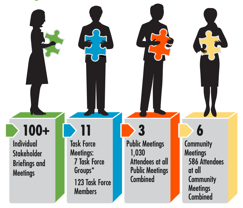
On the other hand, the section on public outreach efforts has significantly more exciting information about how IDOT views the project. The document breaks the process down into simple numbers; 100+ stakeholders, 11 task force meetings with 7 task force groups and 123 task sorce members, 3 public meetings with a total of 1,030 attendees, and 6 community meetings with 586 attendees altogether. The section also goes over other outreach efforts made in 2019, highlighting events held at libraries, the Active Transportation Alliance’s annual Bike the Drive fundraiser, and social media, where the project has around 500 followers on both Facebook and Twitter.
The most essential section of this handout, however, is all the way down at the bottom, detailing the comments received; out of around 2,000 submissions, IDOT broke them down into Topics and Locations. Topics were ranked with “NLSD Roadway, Needs” first, followed by “Junction Concerns,” “Pedestrians/Bicycles,” “Lakefront Trail Improvements,” and “Transit Improvements.” Meanwhile, Locations listed Chicago Avenue, then Belmont Avenue, and lastly, the Oak Street S-Curve.
Shifting our attention to the “Lakefront Trail and Park Access” handout, the first thing that stands out is the statement that “65 percent of Public Meeting #3 Survey respondents stated that they used the Lakefront Trail and park paths as a recreational bicyclist. 71 percent stated that they used the same paths as a pedestrian in the past year.” It highlights the fact that, regardless of their primary mode of travel, a significant portion of Chicago residents uses the trail.
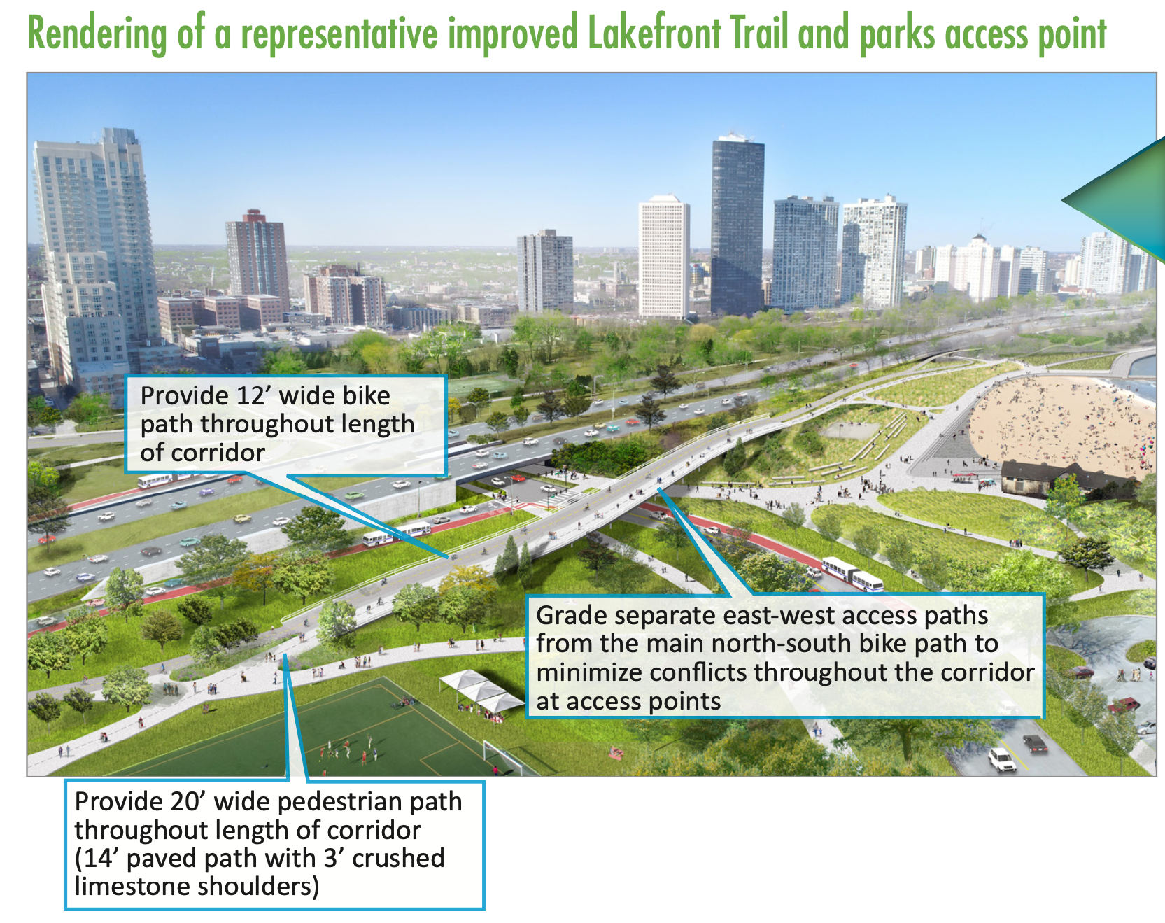
The second page of “Lakefront Trail and Park Access” includes several new renderings with massive new overpasses to provide grade separation between north-south trail users and east-west traffic. These flyovers will likely be the first thing cut from the project as the budget comes into focus. There are also images of additional green space and enlarged beaches, which would definitely be helpful for social distancing if — God forbid — the current pandemic drags on for years, or we see another similar health crisis in the future.
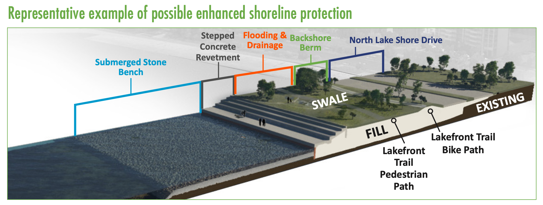
The “Environment and Climate Change” handout highlights the plans for additional green space, shoreline protection techniques, green infrastructure for storm water management, and improved drainage facilities at pedestrian underpasses. These things are all well and good, but if the design ultimately chosen maintains the status quo of eight lanes for private vehicle drivers with no dedicated transit lanes, a very possible scenario, they’ll simply be lipstick on a pig. Doing so would be a symptom of our country’s general failure to rise to the challenge of properly addressing global warming.
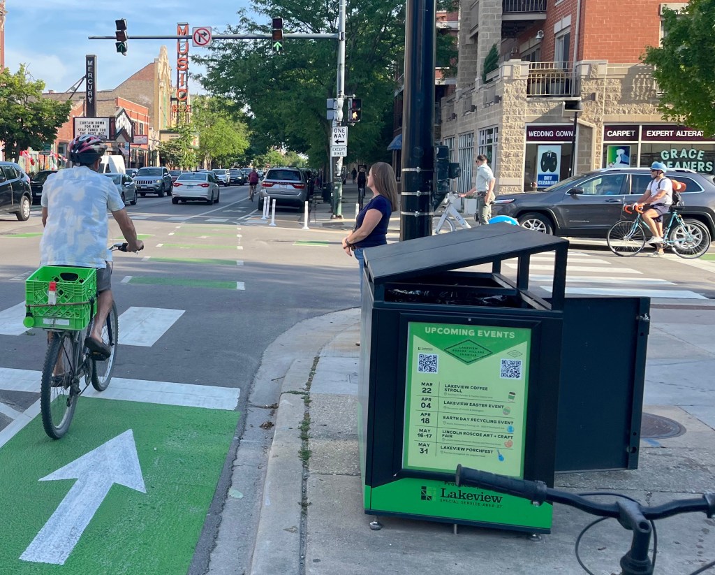
Speaking of failing to rise to the challenge, the “Transit Improvements” document highlights the relatively minor “transit advantages” that would be included in all North LSD reconstruction scenarios: bus-only queue jump lanes or bus-only ramps; transit priority signals; bus turnarounds within Lincoln Park; and bus staging areas nearby Lincoln Park bus stops. The handout notes that “over 69,000 transit riders per day use the seven express bus routes on NLSD and the two bus routes on Inner Drive (2013 data). 73 percent of Public Meeting #3 survey respondents stated that they have taken a bus on Inner/Outer NLSD in the past year.”
The handout promises that all of the possible alternatives will provide a 14-39 percent time reduction during average traffic conditions and a 33-48 percent time reduction during poor traffic conditions. IDOT also projects that overall bus reliability will increase by 58-88 percent. These numbers sound good, but there’s the question of whether there will be any enforcement to prevent car drivers from misusing the bus facilities, as well as what future private vehicle numbers and bus ridership will look like.
IDOT recently tried to rule out the possibility of full bus-only lanes on the drive. But after a backlash from transit advocates and other residents, the department reversed that decision.
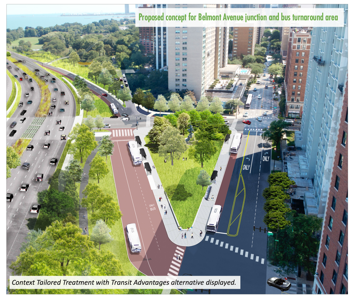
One nice thing about the “Transit Improvements” document is the inclusion of a new rendering for Belmont Junction showing badly needed bus lanes on the junction and new pedestrian pathways, although it doesn’t depict bus lanes on the drive itself.
On the new community input website, IDOT has set up a virtual public meeting with plenty of videos and graphics to explain the project, and you can even sign up to join the task force. In addition to a typical public survey, there’s a Public Ideas Wall that has already filled up with a significant number of posts. Two small group discussion days will take place on October 13 and 14. These are limited to 20 people for each one-hour session, so signing up sooner rather than later is strongly encouraged.
It’s good to see IDOT trying to communicate with the public and get them involved in the planning process. That said, more advocacy is going to be needed to push decision makers from taking the path of least resistance with a reconstructed LSD that maintains the car-centric status quo, to one that prioritizes reducing car trips and increasing transit trips as a strategy to reduce crashes, wasted travel time, and climate change.
To contact the planners with your thoughts about the project, click here.

Streetsblog has migrated to a new comment system. New commenters can register directly in the comments section of any article. Returning commenters: your previous comments and display name have been preserved, but you'll need to reclaim your account by clicking "Forgot your password?" on the sign-in form, entering your email, and following the verification link to set a new password — this is required because passwords could not be carried over during the migration. For questions, contact tips@streetsblog.org.