This article is part of our new weekly Q & A feature, “The Chicago Transportation Authority,” presented by Keating Law offices. Send us a question that you want answered via email (jgreenfield[at]streetsblog.org) or a tweet (@streetsblogchi). You can also post a query in the comment section of this article or on our Facebook page.
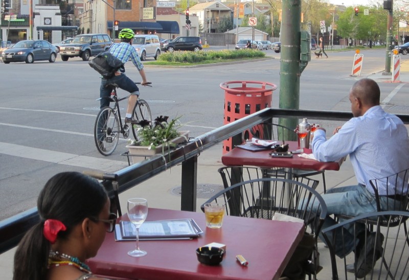
Where’s the proper place to stop on your bike at a red light when there’s a potential for cars to make a right on red? I usually stop on the right side [of the right-most lane], but that would be blocking any driver that wanted to make a right on red. There’s not always a clear place to be “in the middle,” to the right of cars heading straight, and to the left of right-turners. – E.S.
In this scenario, it’s pretty much impossible to stand with your bike in a place that’s totally safe and/or where there’s no chance that you will be in the way of a turning driver. And I hate when I’m standing in the right-most lane and a driver who wants to turn right impatiently honks at me. To be honest, when that occurs, that tends to want make me stand my ground and not move out of the way.
But, on the bright side, that rarely happens to me anymore. I tend to position myself on the border of the through lane and the right-turn lane, or else in the middle of the right-turn lane. I try to glance backwards now and then to keep tabs on what’s going on behind. If I notice that there’s a driver behind me with their right turn signal on, I shuffle to the left to make room for them to turn. Motorists seem to appreciate that, and I often get a hand wave or a polite tap on the horn from them in return. Thus, a situation that has the potential for bad vibes instead turns into an opportunity to earn some good bike karma.
As a follow-up to the question of why the #74 Fullerton bus doesn’t go farther east, why doesn't the CTA’s #12 Roosevelt bus go to Adler Planetarium anymore? I find it especially irritating given that West Siders used to have straight shot to get to the 12th Street Beach and the museums. When I was a kid people felt safe putting their kids on that bus knowing it was going straight to an impossible-to-miss destination. – C.O.
Nowadays the Roosevelt bus originates at Harrison Street and Central Avenue, heads south to Roosevelt and then east to the Illinois Medical District, where the route jogs northeast on Ogden Avenue, east on Taylor Street, and south on Damen Avenue back to Roosevelt. From there the line continues east to Indiana Avenue (a block east of Michigan Avenue), where it turns around by heading south to 16th Street, west to Michigan, and back north to Roosevelt. That leaves you a few blocks from the Field Museum and the Shedd Aquarium, and about a mile from the Adler Planetarium and the neighboring 12th Street Beach.
“As part of a bus network system review, service enhancements were made to seven bus routes,” CTA spokeswoman Irene Ferradaz told me. “These changes took into consideration changes in ridership trends and were designed to improve overall travel in and around the growing South Loop area.” In December 2008, the #12 bus route was extended south to connect the South Loop to the growing Roosevelt Road corridor.
At the same time, the #146 Inner Drive/Michigan Express bus route was modified to operate southbound on State Street to Roosevelt Road in order to connect to the Roosevelt Red, Green, and Orange line station before continuing to the Museum Campus, turning around at the planetarium.
“One of the factors considered in this bus route modification included low ridership on the #12 Roosevelt route west of State Street, going to Museum Campus,” Ferradaz said. “Data showed that approximately 85 percent of #12 customers who were going to Museum Campus would be served by the #146, once it was modified to make the Roosevelt rail station connection. Ferradaz said the CTA's trip analysis was based on an origin-destination survey of customers and analysis of the agency's automated passenger counter data, which counts passengers boarding and alighting the bus.
In other words, the CTA decided that since their data showed only about 15 percent of Roosevelt bus riders who were headed to the Museum Campus or the beach started their trips west of State Street, it wouldn’t inconvenience too many people if they rerouted the #12. "The goal of this service modification was to better connect the growing [South Loop] residential area to employment opportunities and educational institutions,” Ferradaz said.
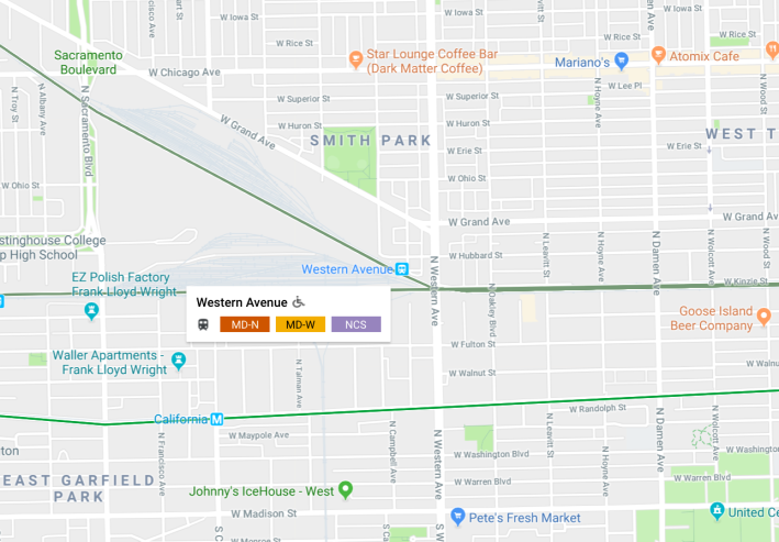
Metra's Western Avenue station in West Town serves three different routes, so it's possible to get confused about which train is yours. Image: Google Maps.Why doesn’t Metra label its trains to make it easy to tell which route a train is traveling? All the trains look the same when pulling into the station, and it gets confusing if a stop serves multiple lines. – S.C.H.
“I’m not sure even if I did a deep dive into our historical records and the historical records of our predecessor railroads that I could find a moment where the question of exterior signage on locomotives and cars was considered and debated and I could definitively answer you,” said Metra spokesman Michael Gillis when I contacted him a couple of weeks ago. “But the answer probably is that most lines have distinct routes and serve distinct stations, and there has not been a need or a demand for such signage.”
Gillis conceded that a few stations do serve multiple routes. The Clybourn stop, which serves the UP-North line to Kenosha and the UP-Northwest line to Harvard, is an example. But he noted that there are two different platforms, and signs notifying customers which platform serves which line.
The Joliet station is also serves two lines, he noted, but has separate platforms with signage.
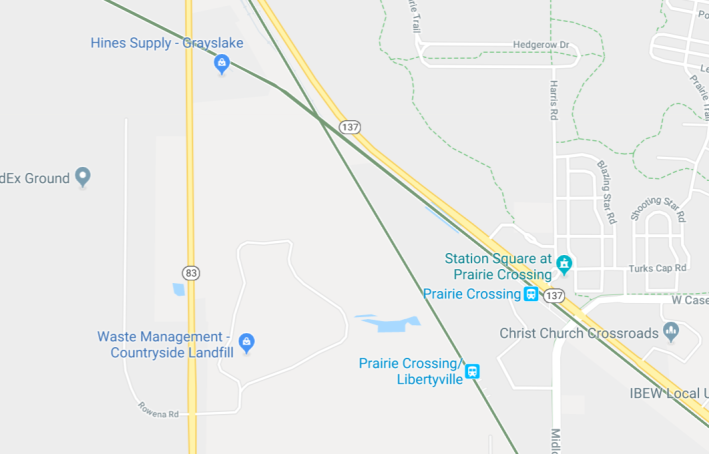
The Prairie Crossing and Prairie Crossing / Libertyville stations, serving the MD-North line to Fox Lake and the North Central Service route to Antioch, respectively, are located close to each other but are still two distinct, separate stations. (And the tracks of the two lines do, in fact make a crossing in the prairie just northwest of the stations.)
Gillis noted that there are only two stations outside of downtown that serve more than one line from the same platforms. The Western Avenue station in West Town serves the MD-North line, the North Central Service route, and the MD-West line to Elgin. And The River Grove station serves the North Central Service and the MD-West line.
“At those stations, and at the five downtown stations, we try to address any confusion about lines or branches with station signage and platform announcements,” Gillis said. “We would also encourage customers to ask the conductor before boarding, if there’s any confusion.”
Gillis added that Metra Electric District trains do have external signs that display the trains’ run numbers. “Since the line has trains serving several different zones and branches, displaying the run number is another way to help people find the right train, especially at the downtown stations.”
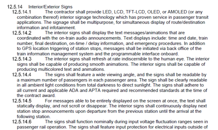
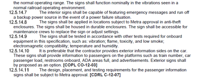
Last week Gillis provided an update that’s good news for the Metra-confused. On March 20 the railroad issued a request for proposals for at least 200 new rail cars, and it’s allowing manufacturers to propose alternative car designs that could potentially work better than the bi-level cars that have been used in Chicago for nearly 70 years. The RFP requires a car with internal signage, and also says “it is preferable” that the cars have exterior signage that would provide info to customers on the platforms. “So external signs are an option that they can propose, not one they are required to propose,” Gillis said. Check out the language from the RFP, below.
This post is made possible by a grant from the Illinois Bicycle Lawyers at Keating Law Offices, P.C., a Chicago, Illinois law firm committed to representing pedestrians and cyclists. The content is Streetsblog Chicago's own, and Keating Law Offices neither endorses the content nor exercises any editorial control.