People for Bikes’ “Bike Network Analysis” Gave Chicago a Low Score, but We Can Improve It
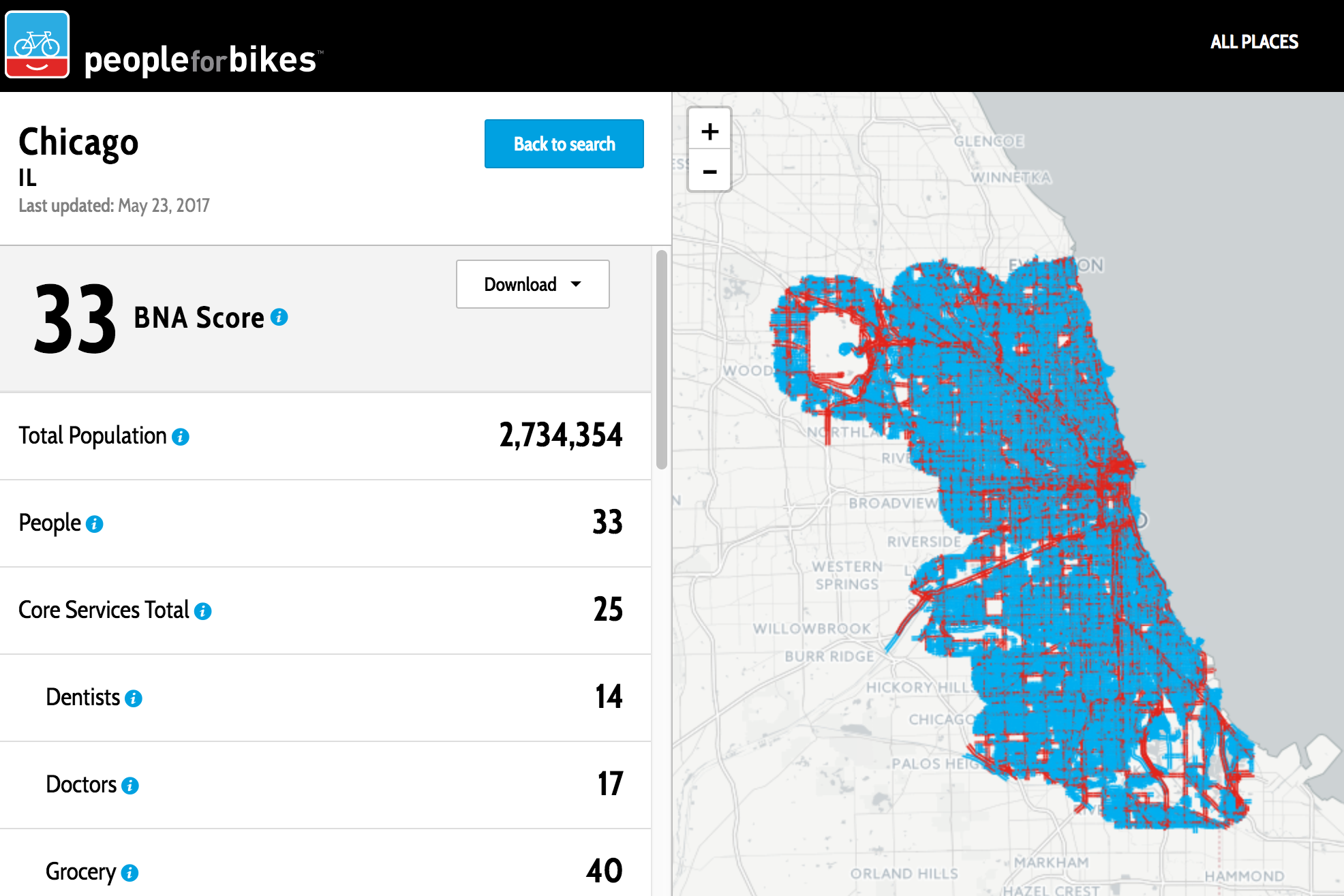
So far Chicago only has a BNAS rating of 33 out of 100 possible points. High-stress streets are shown in red and low-stress streets are shown in blue. Image: People for Bikes
The national advocacy group People for Bikes just announced their new Bike Network Analysis scoring system, with maps and ratings for hundreds of U.S. cities based on how easy it is to cycle to various types of nearby destinations on mostly low-stress routes. Unfortunately, so far Chicago has a very low score of only 33 out of 100 possible points.
The BNA consists of two maps: one for streets and one for blocks. The streets map loads by default and shows streets as low-stress (blue) or high-stress (red) based on its characteristics like the number of travel lanes, the speed limit, and what kinds of bike lanes they have on them, if any.
The blocks map shades blocks by their BNA score (activate it by clicking on the layer chooser icon in the top-right corner). The bluer a block appears, the higher the number of connections it has to nearby destinations and other residents via low-stress routes within 10 minutes. The redder a block appears, the lower the number of connections it has.
Just like any analysis that's done manually or methodically, the accuracy of the BNA is subject to debate. Data-driven analyses of bike networks aren't completely free from bias, nor are largely qualitative rankings, such as Bicycling Magazine's controversial announcement last year that Chicago is America's best city for biking. The BNA is based on a flexible dataset that anyone can contribute to, OpenStreetMap.
Using this open-source map of the world gives BNA creators Jennifer Boldry and Spencer Gardner free data showing the locations of businesses across the entire country. The BNA also uses population data from the U.S. Census to measure every block and measure how many people living on other blocks one can reach by bike within 10 minutes (about 1.7 miles if you're cycling at 10 mph).
New York City got a slightly lower BNA score than Chicago at 30 out of 100, but scored higher on connectivity to transit. That's not surprising, since NYC has twice as many rail transit stations as Chicago, and they may be better distributed among populated areas than Chicago's stations.
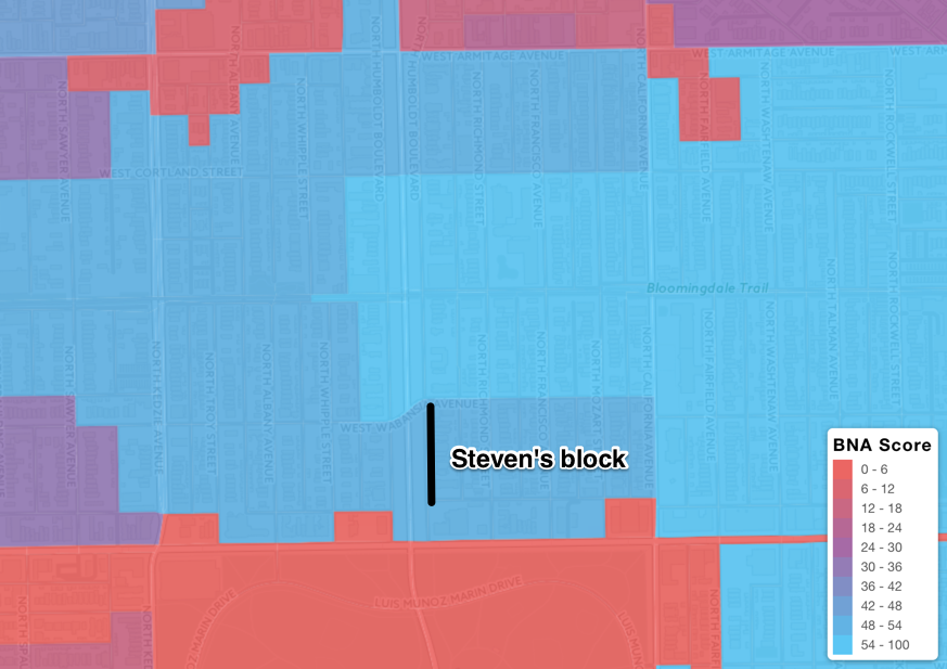
My block of Humboldt Boulevard, just north of Humboldt Park in the West Town community area, has a BNA score of 48-54 out of 100 because of the boulevard's service drives function as low-stress bike routes, and there are many connections to quiet side streets. However, the rankings of nearby blocks north of Armitage are lower (shown as purple or red) which doesn't make sense to me because those blocks are closer to "core" services, retail, the Blue Line, and schools.
One potential weakness of the BNA rankings is that while OpenStreetMap is free to use, and highly accurate in most places, it's incomplete in many cities. Fortunately, the OSM's data on Chicago is pretty solid. Not only are thousands of businesses mapped, as well as all parks, train stations, schools, and hospitals, all of the bike lanes, streets with "sharrows" (bike-and-chevron symbols), and trails in Chicago are updated through early May 2017. It's likely, though, that Chicago lacks in the mapping of other core services that the BNA measures, including doctors, dentists, and social services.
There will also be disagreements over whether the streets in your neighborhood should be marked in red for high-stress or blue for low-stress. In certain situations, the output can be changed by providing more specific information about streets to OpenStreetMap. For example, specifying the number of lanes on an arterial street and its speed limit would override the assumptions in the BNA. Boldry and Gardner explained the methodology, and the source code is open for peer review.
While Chicago's BNA score is currently low, the good news is that there are ways that we can improve it. For example, the city could create more low-stress routes that connect more destinations, including transit stations and high schools. Since the BNA is based on connectivity between blocks, there are other factors that can increase the score. These include whether or not there are medians or traffic signals to facilitate crossing major streets via bike routes, and the distribution of one-way streets in an area, which can hurt or help a bike connection, depending on which direction you're going.
Chicago scored high on low-stress connections to parks. Our score of 60 in this category says that a lot of blocks in the city have more than one park that's within 10 minutes by bike on low-stress routes.
Another change that would affect Chicago's BNA score is the locations of the destinations that the BNA measures. If doctors' offices are concentrated in downtown and medical districts, and not in neighborhoods, then that score would be low because few Chicago blocks would have a 10-minute long low-stress route to those offices.
So if you want to see a higher score of bike connectivity to social services, you'll have to initiate adding a combination of more social services where people live, and create more low-stress routes between people and social services that are up to 1.7 miles away.
Personally, I think the map would be better if the cycling distance was increased to three miles, which is closer to the average trip length by bicycle. I also think that interstates and expressways and other places where bikes aren't allowed should be removed from the map. Observers can send feedback to People For Bikes, and they can update OpenStreetMap in their neighborhood.
People For Bikes will re-run the analysis after July 14.
Disclosure: The mapping platform Mapzen hired me to update the Chicago bike network in OSM prior to the launch of their new map design. I haven't yet mapped the Glenwood Greenway project that made it possible to bike in both directions on a one-way street.

Stay in touch
Sign up for our free newsletter
More from Streetsblog Chicago
Which Metra corridor would become more bike-friendly and greener under a new plan? Ravenswood!
Thanks to plans to convert little-used parking spaces, the avenue is slated to get a new bike lane, and the Winnslie Parkway path and garden will be extended south.


They can drive 25: At committee meeting residents, panelist support lowering Chicago’s default speed limit
While there's no ordinance yet, the next steps are to draft one, take a committee vote and, if it passes, put it before the full City Council.
One agency to rule them all: Advocates are cautiously optimistic about proposed bill to combine the 4 Chicago area transit bureaus
The Active Transportation Alliance, Commuters Take Action, and Equiticity weigh in on the proposed legislation.