The Forest Preserve District of Cook County is proceeding with plans to extend its popular North Branch Trail three miles further into the city limits, via a sidepath along Central Avenue. The extension has been planned since 1995, and has been shown as a dotted line on the Chicago bike map for several years. Some neighbors, though, worry about how the sidepath will impact cars traveling on or turning off Central Avenue.
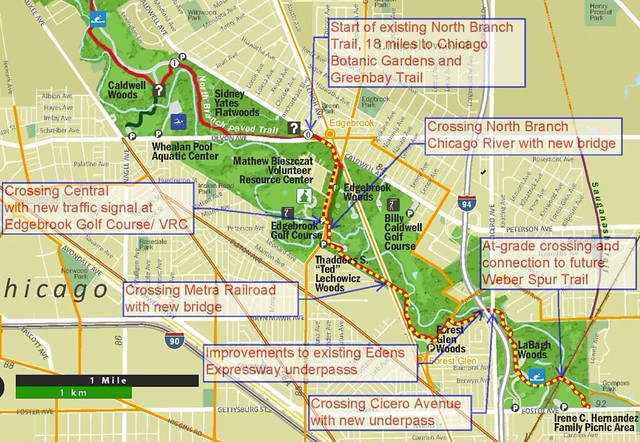
Last week the Forest Preserve hosted a meeting at the Matthew Bieszczat Volunteer Resource Center about the extension, which would start from the trail's current southern terminus at Devon and Lehigh avenues (one block short of downtown Edgebrook) and end at Gompers Park, near Foster and Kostner avenues, in the Mayfair neighborhood The 18-mile trail carries 250,000 users a year between the city and the Chicago Botanic Garden in Glencoe, where a northern extension to the Metra UP-North line opens September 13.
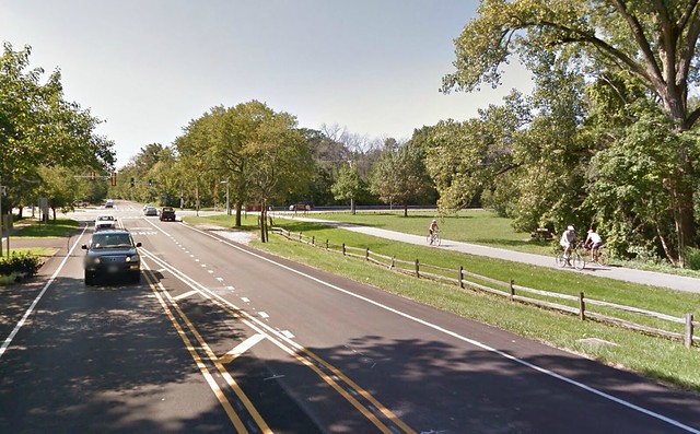
Extending the trail into the city won't be a walk in the park, though. While most of the existing trail runs along the river, the extension must skirt both busy Devon Avenue and the existing Edgebrook Golf Course. To do so, it will run alongside existing roads instead: crossing Devon at Caldwell, then following Central past the three-block Old Edgebrook neighborhood, then crossing Central at a new stoplight placed at an existing intersection that serves the golf course and the Volunteer Resource Center.
Some residents feel that the new traffic signal will "snarl traffic," DNAInfo reported. This is unlikely, since the new traffic signal would be on-demand, and only change when a motorist exits the parking lot or when a bicyclist or pedestrian pushes a button.
The Chicago and Illinois Departments of Transportation examined several alternatives proposed by neighbors and found them wanting. In particular, re-timing the lights at the complicated intersection of Lehigh, Caldwell, Central, and Devon would cost $1 million, and building a traffic signal at Prescott or Louise would make existing traffic backups even worse.
Old Edgebrook residents also worry about how the Central Avenue sidepath would affect vehicle turns into or out of their neighborhood. Brian Sobolak attended the meeting, and recounted that some residents thought that the sidepath's crossings of Prescott and Louise would be unsafe, and might block residents driving in and out. Similarly, Nadig Newspapers reported that some residents believe "it would be difficult to see bicyclists" crossing these two streets, the only routes into Old Edgebrook. Yet Central already has a sidewalk at this location, so drivers at these two intersections already must watch for crossing pedestrians.

A road diet would be one solution to the perceived traffic flow problems along Central Avenue, which sees traffic volumes that CDOT deems appropriate for a diet. They would address a complaint that meeting attendee Bob Kastigar related to Streetsblog – that Old Edgebrook residents probably have a tough time getting in and out of their small neighborhood from busy Central Avenue. Creating dedicated turn lanes from Central's four lanes would give drivers a place to safely wait for a chance to turn. The Forest Preserve acknowledges this in its FAQ, saying "It is anticipated that this new traffic signal will slow down vehicle traffic and provide additional gaps in traffic flow."
Also at the meeting, the Forest Glen Community Club and the Urban Environmental Alliance protested the trail's impact on trees and proposed a different route. Their proposal would reduce the amount of felled trees by not building much of a trail, and instead routing bicyclists onto a convoluted route down neighborhood streets.
Forest Preserve District planner Kindy Kruller highlighted the advantages of the proposed trail, saying, "...forest preserve trails go through green space and offers our users a unique experience without frequent road crossings," and particularly that trails provide a protected space for those who are running, jogging, biking, or roller blading.
Sobolak is looking forward to the trail, he said, because it "connects communities that currently are isolated and have terribly round-about ways of getting around." As for the perceived conflict at Old Edgebrook, Sobolak reframed the issue: "the problem isn't a trail coming to the community, it's that the community already is terrible for traffic. The trail won't move the needle significantly one way or the other."
Ted Villaire, spokesperson for the Active Transportation Alliance, agrees that it improves access and mobility. He told Streetsblog that the trail extension "will allow more people in Northwest Side Chicago neighborhoods to access the Botanic Gardens and the north suburbs with off-street biking routes." The extension is significant for thousands of Chicago residents who don't live at the edge of the city, as it will connect people in Albany Park and adjacent south and east neighborhoods to a widespread, suburban network of car-free bike routes.
Kruller from the Forest Preserve District said that IDOT is reviewing their final proposal and the traffic study for the new signal on Central Avenue. She said at the meeting that construction would start in spring 2015, and take one year.
Kastigar said that, with North Branch Trail extension planning largely complete, the next step is for CDOT to design and build the Weber Spur Trail. This path follows an abandoned rail line that connects the Sauganash Trail with Gompers Park and the Elston Avenue bicycle spoke route, via an existing overpass at Foster. CDOT has started preliminary engineering for the Weber Spur Trail.


