Huzzah! Opening of new underbridge completes 1.5-mile, car-free 312 RiverRun route
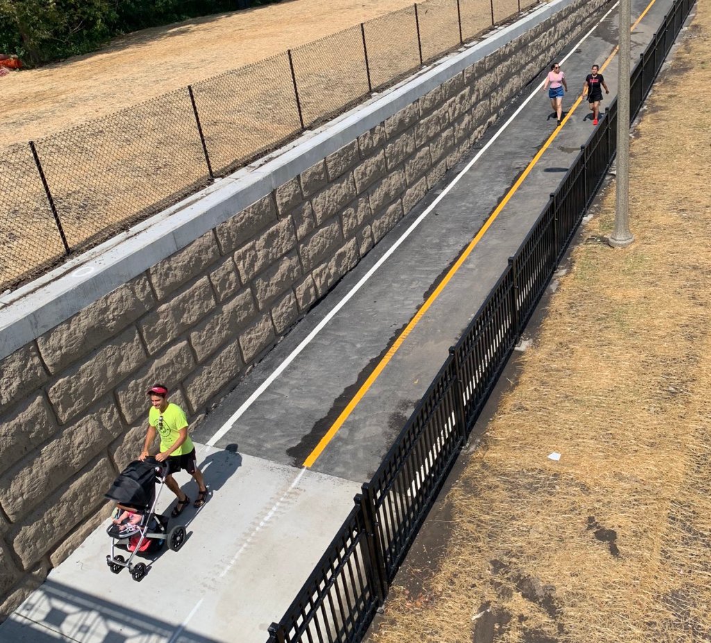
If you don’t already have that Friday feeling, maybe this news will give it to you. The long-awaited bike-pedestrian underbridge along the Chicago River below Irving Park Road opened today, which means you can now travel for a mile and a half between Montrose and Belmont avenues via the 312 RiverRun trail system without so much as having to cross a street.
The other major piece of infrastructure in the RiverRun project was the Riverview Bridge, aka the Hot Doug, which connects the east back of the river at Clark Park (about 3400 N.) with the west bank at California Park, which opened in December 2019. But heading north from there to Horner Park still required crossing Irving Park at street level on California Avenue.
However, the new underbridge allows you continue along the west bank on a new stretch of paved multi-use path, under Irving Park, and up to Horner Park, or vice-versa. From Horner you can travel half a mile north on streets via the on-street Manor Greenway route to Lawrence Avenue, where you can pick up the North Shore Channel Trail, which goes all the way to north Evanston.
The whole 312 RiverRun network covers 95 acres of land providing access to Chicago Park District facilities like wheelchair accessible baseball fields, fitness centers, playgrounds, the McFetridge indoor ice skating rink, tennis courts, an outdoor pool, a boat house, plus Lane Tech high school. The total construction cost was $18.16 million, including $9.66 million in state funding, and $8.5 million in federal grants.
The project also involved the full reconstruction of the Irving Park vehicular bridge, replacing the existing 104-year-old structure and widening it to the same width as the rest of the roadway. Work on the bridge is continuing for the next few weeks. No bike improvements were made to the bridge itself, although the upcoming reconstruction of the mile-long stretch of Irving Park between the river and Ravenswood Avenue, kicking off next week, includes pedestrian improvements such as “about 17” sidewalk bump-outs.
While the 312 RiverRun itself is more-or-less a wrap, the next logical steps would be improving access to the trail system. The most pressing need is for protected bike lanes on four-lane Belmont Avenue, which is quite bike-hostile. A road diet with buffered bike lanes was planned for this stretch of Belmont as of 2015, but was cancelled because the CTA worried it would slow down the Belmont bus.
Access to the RiverRun from the north could be enhanced by added traffic diverters to the Manor Greenway, infrastructure to prevent drivers from using it as a through route. The city tested temporary diverters there in 2016, but gave up on the idea after a backlash from motorists.
Another idea to make it easier to get to the trail system and parks from the east would be a new bike-ped bridge over the river at Berteau Avenue. In the meantime, the city recently striped dashed bike lanes on Montrose, a controversial treatment that I think makes the street a little more bike-friendly.
When you have a chance to test-ride, walk, jog, roll, or stroll the completed 312 RiverRun, let us know what you think in the comments section.

Read More:
Streetsblog has migrated to a new comment system. New commenters can register directly in the comments section of any article. Returning commenters: your previous comments and display name have been preserved, but you'll need to reclaim your account by clicking "Forgot your password?" on the sign-in form, entering your email, and following the verification link to set a new password — this is required because passwords could not be carried over during the migration. For questions, contact tips@streetsblog.org.