The Des Plaines River Trail in Cook County has always struck me as something of a missed opportunity. While it runs near Chicago's West and Northwest sides and has some lovely river views, it's largely a dirt path that is pretty much impassible in damp conditions unless you have a mud-friendly bike. (Once you cross into Lake County at Lake-Cook Road, the trail is paved with crushed limestone, which is much easier to ride after a rain, and it goes almost all the way to the Wisconsin border.) There are also some access issues and disruptions in the route.
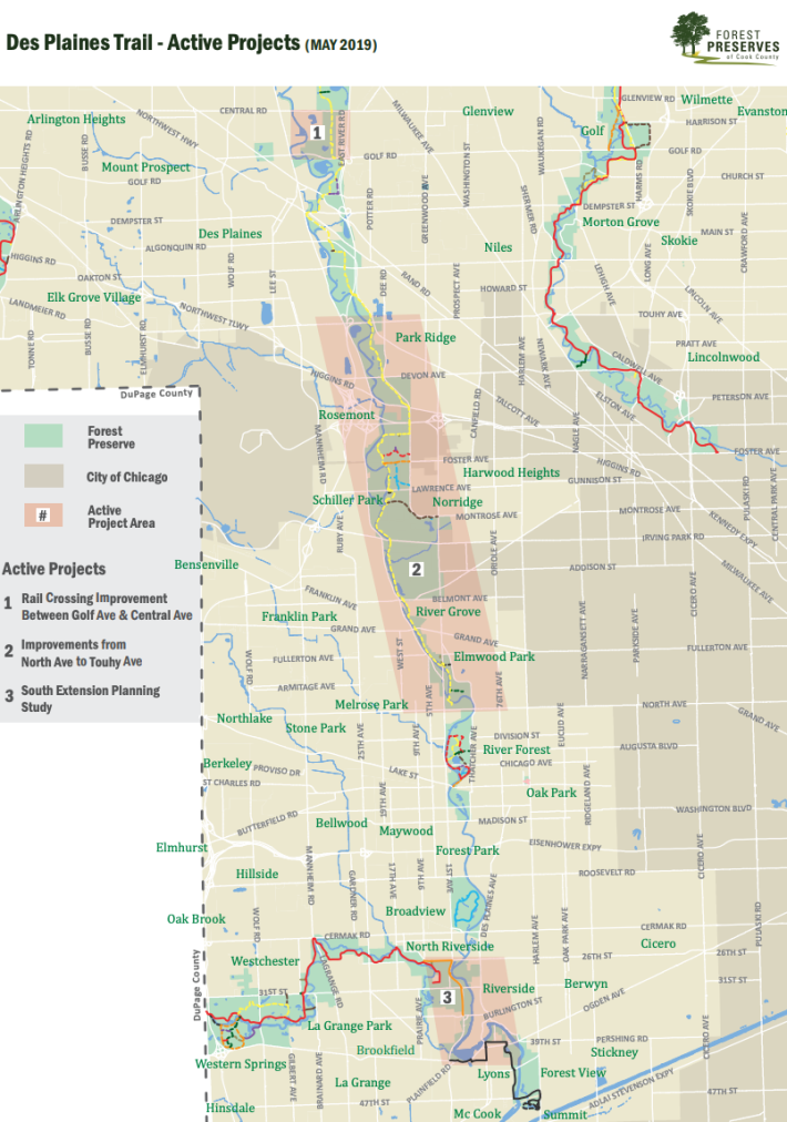
The good news that the Forest Preserve District of Cook County and local suburbs are upgrading several stretches of the DPRT to improve trail conditions and access. Here's a rundown of all the projects that are in the works. Below is a map of the project areas --check out an interactive version here.
Rail Crossing Improvement Between Golf Road and Central Road
According to the forest preserve district, the Union Pacific Railroad tracks between Golf and Central roads (just north of the suburb of Des Plaines) "create a significant interruption to... continuity, present an unsafe environment for trail users and discourage use of the trail by residents of neighboring communities." As it stands, there's no underpass or bridge, so to cross the tracks, some cyclists carry their bikes over the tracks, which is illegal. To address this, FPDCC is rerouting the trail with a bow-shaped itinerary and building a bridge over the tracks.
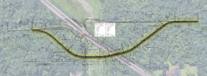
Bridge construction is slated to start in late 2021 and finish the following fall. Check out materials from last year's open house on the project here.
Catherine Chevalier Woods Bridge
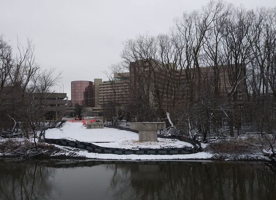
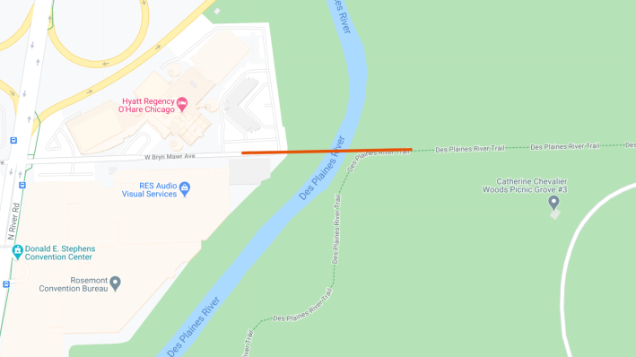
The forest preserve district is building a 12-foot-wide bridge to connect the village of Rosemont to the DPRT, from Bryn Mawr Ave on the west side of the river to Catherine Chevalier Woods on the east, giving Rosemonters car-free bike and pedestrian access to the path, as well as making it easier for Chicagoans to access the village. The $1.3 million project is being largely bankrolled by the state of Illinois, with the suburb kicking in 20 percent of the cash. Work started last August the bridge is projected to open this spring.
Improvements from North Avenue to Touhy Avenue
Rosemont is doing a feasibility study for upgrades to the 10-mile stretch of the DPRT between North and Touhy avenues. The report will recommend improvements to address issues like flooding, safety at road and rail crossings, trail access, and trail user experience, i.e. ways to prevent the trail from being a muddy mess after a rain.
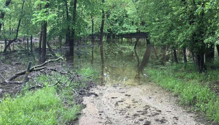
The feasibility study is divided into two parts: North Section (Touhy to Irving Park Road) and South Section (Irving Park to North. The 5.4-mile North Section is on higher and drier ground, further from the river, so the study of this segment is moving faster. There's already a draft under review by the Illinois Department of Transportation.
The forest preserve district and relevant suburbs are currently looking for funding for the following project in the North Section. View an interactive map here.
- Touhy to Devon: Park Ridge is pursuing Illinois Transportation Enhancement Program funds for trail improvements, including standardizing the width and texture of the trail, moving the mid-block crossing at Touhy to the signaled intersection at Talcott Road, and creating an at-grade crossing at the signaled intersection at Devon and Dee Road (eliminating the Devon Ave underpass.)
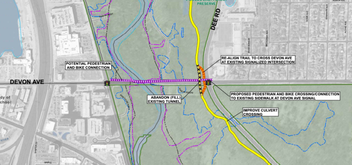
- Devon to Bryn Mawr: Rosemont is seeking ITEP money for rebuilding trail segments and improving crossings at Higgins Road and Dee Road.
- Bryn Mawr to Lawrence Avenue: FPDCC is seeking federal Congestion Mitigation and Air Quality Improvement funds for engineering plans for relocating the trail above the 100-year floodplain and building a pedestrian overpass at Lawrence.
- Lawrence to Irving Park: The forest preserve district is pursuing CMAQ funds and the village of Schiller Park is pursuing ITEP money for engineering and construction for relocating the trail away from the river and out of the floodplain.
The 4.9-mile South Section of the trial, from Irving Park to North, is a tougher nut to crack. It closely follows the river, so it experiences more frequent and longer periods of flooding than the North Section. A feasibility study looked at these flooding issues, along with road crossings and trail conflicts with railroad tracks and private property. The feasibility report considered:
- Moving the trail out of the 100-year flood plain and away from the river, which would impact mature woodland and stream habitats.
- Keeping the current alignment by building an expensive six to eight-foot elevated boardwalk to raise the trail out of the floodplain.
- Rerouting the trail about a mile to the east, closer to Cumberland Road.
Ultimately, the study identified rerouting the trail closer to Cumberland as the most effective way to address flooding and road crossing issues, while minimizing expense and impact on natural areas. View an interactive map of the South Section here. You can also check out a 2018 Active Transportation Alliance report with recommendations for the DPRT here.
South extension planning study
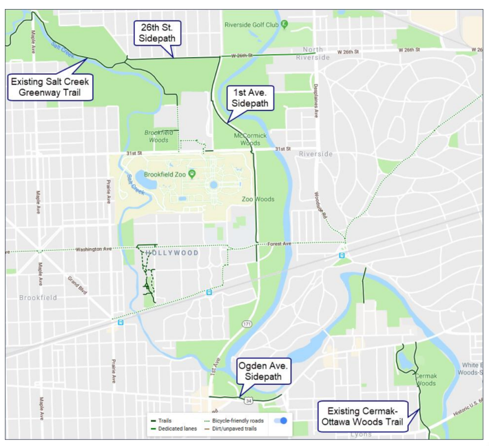
The current southern terminus of the DPRT is at Sunset Bridge Meadow, a bit north of North Avenue. 6.5 miles south of that, there's another 1.3-mile snippet of path along the river in the village of Lyons, between the Cermak Family Aquatic Center on Ogden Avenue, south to the Chicago Portage National Historic Site.
A planning study focused on the southernmost segment of the gap, between 26th St and Ogden, was completed in November 2019, with the goal of identifying the most feasible route for a new stretch of trail in this area, along with access routes to Brookfield, Riverside, North Riverside and Lyons. Last year the West Central Municipal Conference launched a Phase 1 study, a first step toward the goal of closing the entire 6.5-mile gap and creating a connection between the Illinois Prairie Path and Salt Creek Greenway.
So there are plenty of promising projects in the works for the trail that should result in better access and less-soggy post-rain rides. And hopefully some day you'll be able to take an uninterrupted pedal all the way from Lyons to the Cheddar Curtain (the Wisconsin border.)
