The Chicago Department of Transportation is asking for feedback from residents on its plan to improve the stretch of Chicago Avenue between Kedzie and Latrope avenues in Humboldt Park and Austin.
During a virtual meeting Thursday, CDOT officials emphasized over and over again that the corridor currently isn’t safe for any road users. On several sections of the avenue, motorists are often driving at near-highway speeds. They staffers said the lack of left-turn lanes in many locations endangers both drivers and pedestrians. Pedestrian islands are needed to make crossing safer, and bike lanes are needed to provide dedicated space for cycling.
The city is also looking to redesign the corridor to encourage economic development. As part of that, CDOT is considering adding rush-hour bus lanes. The city expects that improving bus speeds, adding bike lanes and calming traffic by narrowing travel lanes, make people passing through the corridor more likely to notice Chicago Avenue storefronts, rather than just speeding by them.
For the next few months, CDOT will be collecting input that will help it fine-tune the plan. The department hopes to have the plan finalized in 2021, with the goal of doing the streetscape project in 2022.
Background
During the presentation, CDOT officials noted that Chicago Avenue is a major east-west commercial and transit corridor. The #66 Chicago Avenue bus is the third busiest route in the city, and it will be a site of the city’s electric bus pilot. Many riders transfer to and between the #66 and major north-south routes that cross it. And the Chicago bus is one of only a few West Side transit lines that operates at night.
While there have been streetscape improvements further west on Chicago Avenue, between Central Avenue and Austin Boulevard, as well as east of Kedzie, the Latrobe to Kedzie section has been neglected. But the corridor has seen some development. The controversial Joint Public Safety Training Academy (better known as the “cop academy”) is being built at 4301 W. Chicago Ave. In 2017, Westside Health Authority, a major Austin nonprofit, established the West Side’s very first Special Service Area, SSA 72 Austin Chicago Avenue Cultural Corridor, on and around the intersection of Chicago and Cicero avenues.
More recently, under Mayor Lori Lightfoot’s Invest South/West initiative, the Austin and Humboldt Park community areas are among the 10 community areas that are being prioritized for development, and the Chicago Avenue corridor in particular has been designated as one of the 12 priority commercial corridors. As part of that, the city recently sent out a request for proposals to redevelop the historic Laramie State Bank building, which is located at the west end of Kedzie-to-Latrobe segment.
During the presentation, Ald. Emma Mitts (37th), whose ward includes most of the segment west of Avers Avenue, and Ald. Walter Burnett (27th), whose ward includes the portion east of Avers, both touted the street improvements as key parts of encouraging economic development in areas that haven’t seen much investment in decades.
“You know, the thing about Chicago Avenue [is], when you drive down on Chicago Avenue [though the neighborhoods], that's the impression you have of this whole community,” Burnett said. “We need to make sure that Chicago Avenue going west of Kedzie has the same impression of vitality, economic development and safety that we have east of Kedzie.”
David Smith, CDOT's bike/ped program manager, explained that, as part of the Vision Zero West Side study, his department looked at the segment and found several major issues. The portions of Chicago Avenue between Pulaski Road and Kedzie Avenue, and between Cicero and Austin avenues, were found to be high-crash corridors.
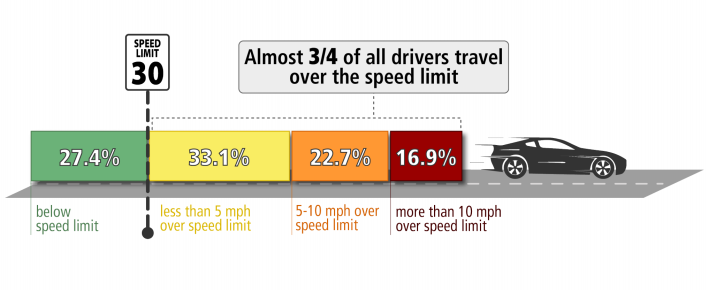
“Only about 27.4 percent [of the drivers] drive below legal speed limits,” Smith said. “31.1 [percent] drive less then three miles over the speed limit. 16.9 percent are approaching highway speed. And that is not acceptable, that is not compatible to building a commercial corridor.”
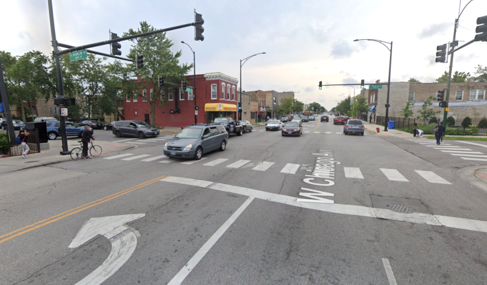
Chicago Avenue has two lanes of traffic in each direction. West of Kostner Avenue, there is a center median to provide separation, but between Kostner and Kedzie, there is only a line. That, Smith said, becomes an issue when pedestrians, especially seniors and families with kids, try to cross the street and can’t quite make it all the way through. Without a median, they can’t set up a pedestrian island where people walking can safely wait until they can finish the crossing.
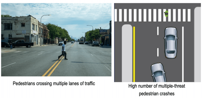
The lack of left-turn lanes at many intersections further compounds the problem, Smith said. CDOT studies and conversations with local residents show that it’s not unusual for a driver to stop while a pedestrian is crossing the street, and have the motorist behind them not realize why the first driver stopped and try to get around them, striking the pedestrian. This is known as a "multiple threat" crash.
Smith noted that, while pedestrians who are struck by a driver going at 20 miles per hour have 90 percent chance of surviving, the odds drop exponentially the faster the car is going. At 40 miles per hour, the chance of survival drops to 20 percent. “So that's a really big focus of this project, to slow down traffic and making sure people are driving at acceptable speed.” Smith said.
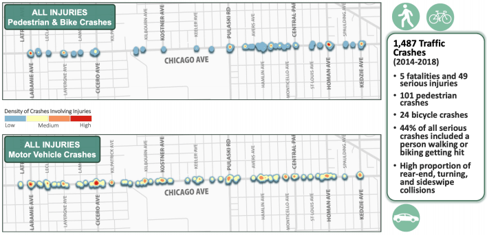
CDOT looked at the crash data between 2014 and 2018 and found that 1,487 crashes in the segment resulted in someone being injured. That included 29 people being seriously injured and five deaths. The segment also saw 24 bicycle crashes.
In one pedestrian case on May 23, 2020, a man was crossing the street in the 3800 block of West Chicago Avenue, when a motorist struck him and fled the scene. As he was lying in the street, another driver ran over him again.
“44 percent of all serious crashes includes someone walking or biking,” Smith said. “So, when you’re walking or biking, you’re much more vulnerable.”
Improvement Plans
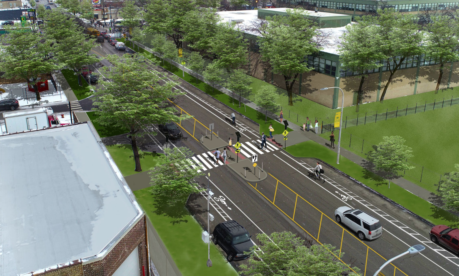
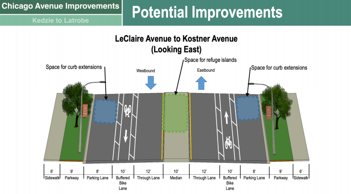
While the plans have not been finalized, Smith explained that CDOT officials do have general ideas for what they want to do. They's like to add pedestrian crossing signals at the streetlights that don’t already have them, and install curb bump-outs at intersections to shorten crossing distances. In some locations they would do a road diet, converting two of the four travel lanes to parking lanes and bike lanes. West of Kostner, they want to add pedestrian islands at the intersections. East of Kostner, they would put in a middle lane that would act as a continuous a left-turn lane in both directions.
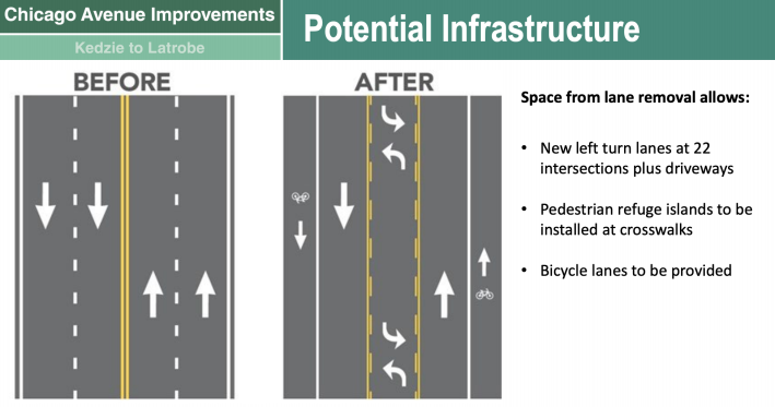
“By doing that, we open up more options and variables of space, to provide more space for people to walk and bike,” Smith said, adding that reducing the number of lanes would help calm traffic.
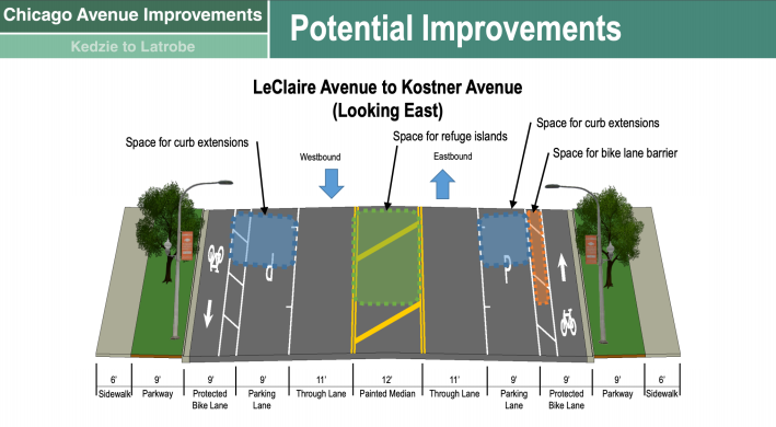
The bike lanes could potentially be curbside, parking-protected lanes, Smith said. West of Kostner, Smith said, it would be possible to create buffered bike lanes, but it would become trickier further east, where there would be less room.
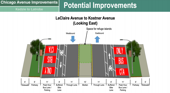
CDOT is also considering creating rush-hour bus lanes by banning parking during those hours. The downside, Smith said, is that it wouldn’t be practical to put in pedestrian bump-outs at these locations, because they would obstruct buses operating in the curb lane.
The funding for the project will come from the federal Highway Safety Improvement Program grant. While this money can only be used for traffic improvements, Smith argued these improvements would indirectly support economic development as well. "A safe and accessible Chicago Avenue is key to supporting local businesses."
Check out the meeting presentation here.
To leave feedback and suggestions on the Chicago Avenue plan, e-mail CDOT at info@chicagocompletestreets.org
Fllow Igor Studenkov on Twitter at @istudenkov.
