Our Transit-Style Map of the Chicago Bike Network Highlights Coverage, Equity Issues
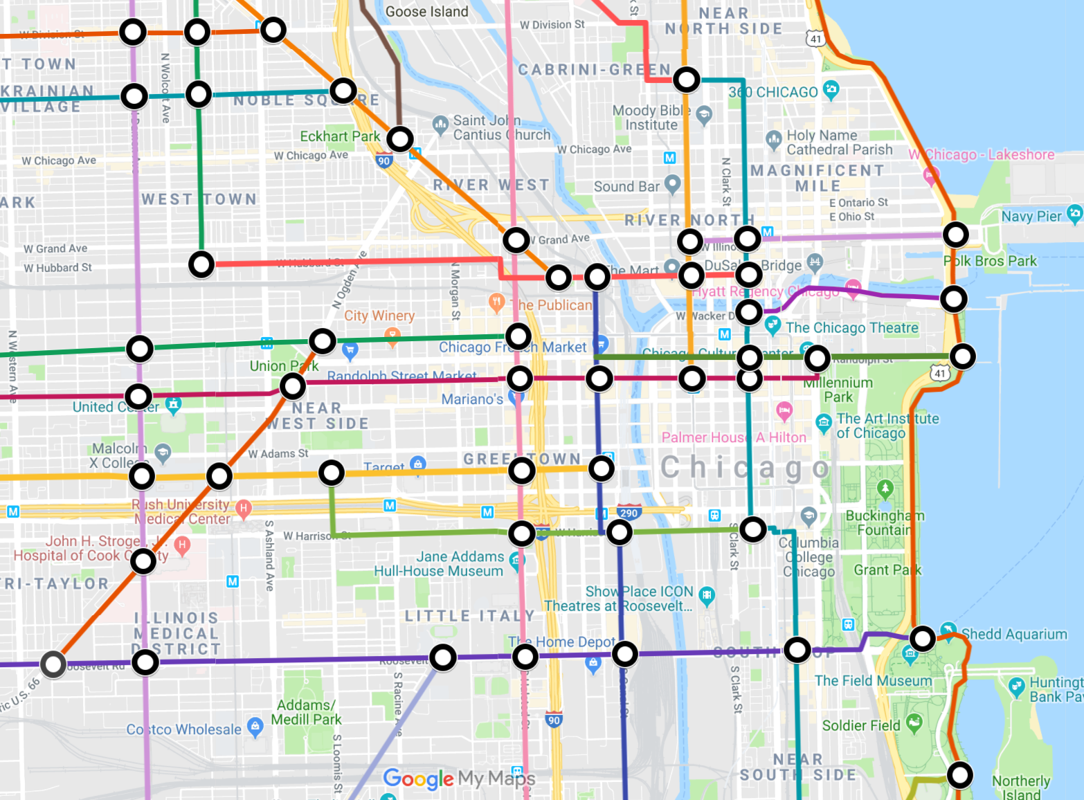
The downtown portion of the map. The “stations” are locations where routes intersection. Click on the lines in the map below for route names; click on the stations for the station names. Image: Google Maps
Recently the urban planning website CityLab highlighted bike enthusiast and cartographer Michael Graham's "Spider Bike Maps" idea, translating urban bike networks into subway-like maps. The idea was to simplify bike maps and make them more intuitive for newbie cyclists to use. Graham has created maps for 14 different cities or metro areas across the country and around the world, including New York, Washington, D.C., San Francisco, Portland, London, Barcelona, and Bogotá.
However, Graham hasn't done a transit-style map for Chicago yet, so I thought I'd take a stab at it. While his maps are highly simplified and stylized, which makes them relatively easy to wrap your head around, I went a little nuts and included just about every major marked bikeway in our city. I generally didn't include routes that are simply indicated with signs but no pavement markings. On the other hand, I was fairly generous about illustrating routes as continuous, even if they have gaps of a few blocks between marked sections. However, I generally didn't include "orphans," bike lanes that don't connect with any other bikeways.
Note that my map assumes that you are somewhat familiar with the street grid, so it doesn't indicate when routes only work in one direction (most of the itineraries work in both directions), and in some cases couplets of one-way streets are simplified into a single route. For example, the Roscoe and School / Aldine neighborhood greenway in Lakeview is westbound on Roscoe and eastbound on School and Aldine, a block south of Roscoe, but I just illustrated the route with a single line located between the two streets. I did the same thing with Illinois (eastbound) and Grand (westbound) in River North.
Even so, I'd like to think that this map makes it a little easier to choose routes to your destination than the Chicago Department of Transportation's Chicago Bike Map, which is also a handy tool, but contains a lot of information that can be a little hard to process. Note that both this transit-style map and the Chicago Bike Map focus on main street routes. If you're looking for relaxing, low-traffic itineraries on side streets, take a gander at the Mellow Chicago Bike Map, which I created for the Chicago Reader. It currently covers most of the city, and I'll be expanding it citywide this summer.
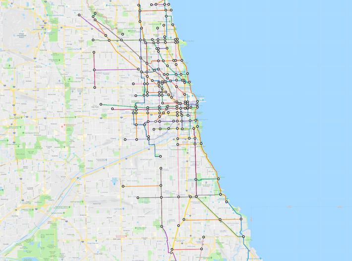
Looking at the Chicago bike network as a transit map (click on the lines for the route names; click on the "stations" for local landmarks and destinations) highlights some of the issues with out current bikeway system. Most glaringly, while there's a pretty good density of marked bike routes downtown and on the relatively affluent, whiter North and Northwest sides, much of the South and West sides have few or no bikeways. Hopefully the $50 million a year that was earmarked for bike/walk infrastructure in the new Illinois capital bill, with measures taken to encourage equity, with help level the playing field.
But even in the more bike-friendly parts of town, the situation isn't fantastic. On the North Side, there aren't a whole lot of good east-west marked routes, partly because the CTA often pushes back against road diets to make room for bike lanes on bus route streets. The West Side has a few different east-west options, but a dearth of north-south routes, largely because the area is broken up by the Eisenhower Expressway and several industrial zones. And the South Side, especially the Far South Side, doesn't have a whole lot of bike lanes, period.
Hopefully this map isn't too overwhelming and will help you better understand how our bike network functions, and where there's room for improvement. I may revise it into a simplified version in the future. If you spot any errors or have ideas for improvements, leave me a note in the comments or drop me a line at jgreenfield[at]streetsblog.org. Oh, and if you think you can do a better job of creating a transit-style Chicago bike map, go for it -- I'd be interested to see different interpretations. Thanks!
Read More:
Stay in touch
Sign up for our free newsletter
More from Streetsblog Chicago
Elevated Chicago’s new leader on how to build more support for equitable transit-oriented development
Recently announced as executive director Juan Sebastian Arias also shared his POV on Mayor Johnson's Cut the Tape initiative to speed up the development approval process


Since COVID, Pace ridership has fared better on major corridors and in north, northwest suburbs than in south, west ‘burbs
The suburban bus system's top five busiest routes largely maintained their ridership rankings.

Due to incredible support from readers like you, we’ve surpassed our 2023-24 fundraising goal
Once again, the generosity of walk/bike/transit boosters is fueling our reporting and advocacy.