Wicker Park / Bucktown Plan Has Great Ideas for Improving Transportation

Today Wicker Park Bucktown SSA #33 released the updated Wicker Park Bucktown Master Plan, a five-year strategic plan for the neighborhood, including some intriguing ideas for improving transportation access and public space. The document addresses some of the area’s biggest trouble spots, including the chaotic, car-centric North/Damen/Milwaukee intersection, the crash-prone Milwaukee Avenue corridor, and the dangerous and dismal Cortland/Ashland viaduct.
It also calls for improving open space in the community through better connections to the Bloomingdale Trail, and the development of new public plazas and “parklet” mini parks. The plan also includes chapters on community engagement, arts and culture, development, quality of life issues, and implementation.
The planning process, led by the planning and design firm Teska Associates, included participation from the Chicago Department of Transportation, the local aldermen, the Chicago Police Department, community organizations, and local businesses. The SSA also took input from residents via a series of community forums, an interactive website, and other outreach methods.
The plan notes that Wicker Park / Bucktown (WPB) is blessed with excellent transit access, including the O’Hare branch’s Division, Damen, and Western stations, frequent bus service on the retail corridors, and the Clybourn Metra stop, Chicago’s busiest station outside of the Loop. The neighborhood is also a hotbed for bicycling, thanks in part to the Bloomingdale, aka The 606, and many Divvy stations, and this year the city’s first bike counter will be installed next to a transit-oriented development by the Division stop. “Yet improvements can be made to improve safety and balance all users from pedestrians to cars to bicyclists and transit riders,” the plan states.
Objectives and projects to improve transportation include taking steps to help eliminate traffic fatalities, in line with the city’s upcoming Vision Zero plan, such as adding countdown timers to all walk signals, installing a mid-block crossing at the Western CTA station, as well as pedestrian islands at other locations on Western.
The plan calls for reclaiming space for pedestrians and cyclists by widening the sidewalks along Milwaukee and adding bike lanes to the WPB stretch of Chicago’s busiest biking street. It also advocates making improvements to the run-down Polish Triangle plaza by the Division station, locating sidewalk cafes in a consistent zone to facilitate walking, and converting parking spaces to parklets on a temporary of permanent basis.
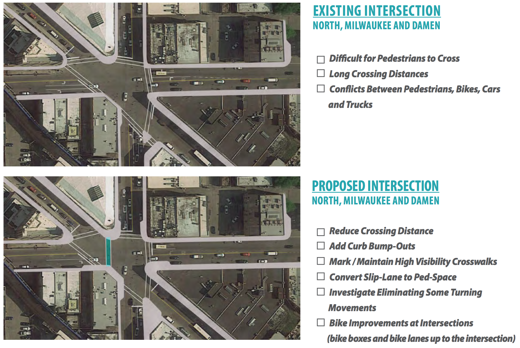
The document recommends improving the area around the Cybourn station, including public art in the Kennedy Expressway viaduct, improving the condition of all the underpasses, and installing wayfinding signs from the Blue Line stops to other points of interest. It calls for reconfiguring North/Damen/Milwaukee to better serve, pedestrians, transit users, and cyclists, making existing bike lanes more visible, and sponsoring additional bike-share stations.
The plan advocates for reforms to parking and loading zone policy to make street space work more efficiently. And it recommends extending the Bloomingdale east, improving connections to the trail from the north and east, and adding more wayfinding signs from on-street bike routes to path access points, as well as from the trail to points of interest in the neighborhood.
Now let’s take a closer look at some of the key recommendations. The plan calls for paying special attention to potential safety improvements at six-corner intersections, and it particularly focuses on North/Damen/Milwaukee. It notes that long pedestrian crossing distances could be reduced via curb extensions, safety could be improved by eliminating the slip lane at the southern corner, and a new, direct crosswalk should be created between the southwest and northern corners, which is already a popular – but currently unsafe and illegal – pedestrian route. It also calls for the possible elimination of some turns by motor vehicles, and the extension of bike lanes up to the intersection and installation of bike boxes, marked areas where cyclists can wait in front of car traffic for the light to change (encouraging stoplight compliance.)
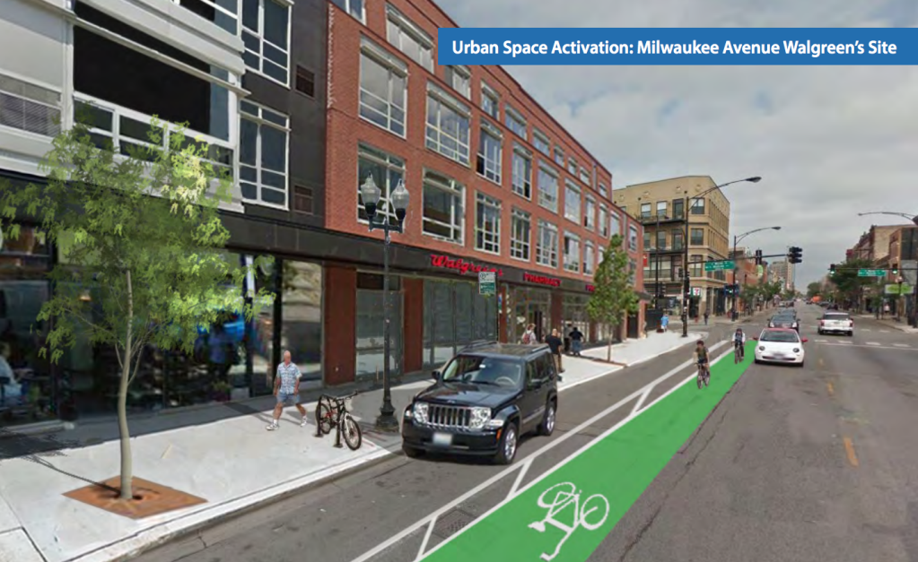
There has been an epidemic of doorings along Milwaukee in WPB so, thankfully, the plan proposes improvements to make the street less car-oriented, including adding bike lanes. The plan recommends working with CDOT to pilot bike lanes on the avenue and developing a report to summarize the findings and lessons learned. Renderings show 5-foot-wide solid-green bike lanes with striped buffers on one side – the buffers would be most useful on the outside of the lane, to help prevent doorings. The document also recommends looking into reducing the speed limit on Milwaukee from 30 mph to 20 mph, which could definitely help to make it a safer street for all transportation modes.
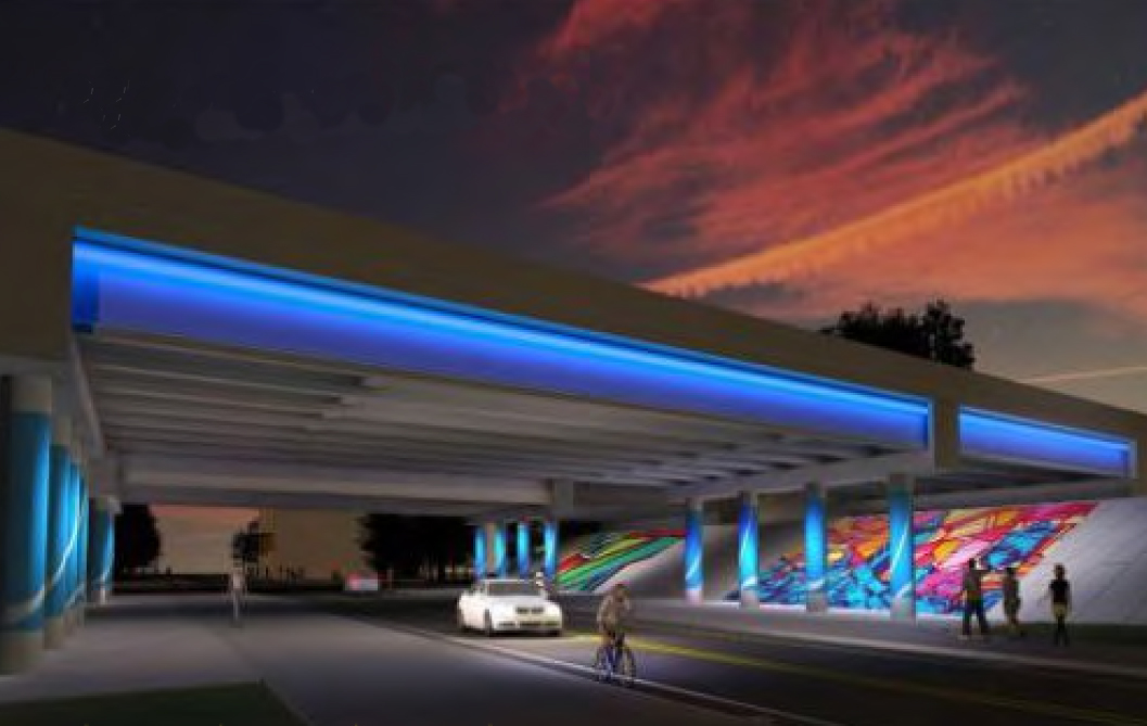
The plan notes that the Clybourn Metra station is a huge asset for the neighborhood, but accessing it requires traveling under long, gloomy viaducts under the Kennedy. The plan recommends rehabbing the underpasses, adding wayfind signs to help transfers between trains and buses, and adding murals and/or decorative lighting to brighten up the space.
At first perusal, the Wicker Park Bucktown Master Plan appears to have many good ideas for improving transportation and general livability in the neighborhood. We’ll likely provide more info about some of the other proposals in the near future.
This post is made possible by a grant from the Illinois Bicycle Lawyers at Keating Law Offices, P.C., a Chicago, Illinois law firm committed to representing pedestrians and cyclists. The content is Streetsblog Chicago’s own, and Keating Law Offices neither endorses the content nor exercises any editorial control.

Read More:
Streetsblog has migrated to a new comment system. New commenters can register directly in the comments section of any article. Returning commenters: your previous comments and display name have been preserved, but you'll need to reclaim your account by clicking "Forgot your password?" on the sign-in form, entering your email, and following the verification link to set a new password — this is required because passwords could not be carried over during the migration. For questions, contact tips@streetsblog.org.