Unfortunately, a transportation project that has the potential to positively transform the University of Illinois at Chicago's campus was passed over for federal funding. The $29.3 million initiative, called Crossroads & Connections, would make significant changes to campus streets in order to make walking and biking safer and more convenient.
The university was seeking $17.2 million in Transportation Investment Generating Economic Recovery funding. This discretionary grant program from the U.S. Department of Transportation finances "transformative" projects that would have at least a citywide impact on safety. The remaining funds would have come from UIC's parking revenue, because the project would have included replacing asphalt in some parking lots with permeable pavers to reduce the amount of runoff sent to the city's sewer system.
The only Chicagoland TIGER application to win funding this year was a railroad bridge over the Fox River near Elgin used by Metra trains. A new pedestrian bridge at 35th Street over railroad tracks and Lake Shore Drive that's currently under construction is also funded by TIGER.
Crossroads & Connections would have addressed many dangerous and annoying situations for people walking and bicycling on the UIC campus, including several pet peeves I accumulated while studying there for four years. It would create smoother cycling connections, build new pedestrian plazas, and legitimize walking routes that weren't being accommodated before.
The university also wants to reduce crashes and injuries by modifying high-risk intersection and crossing points. The plan notes that that 252 people were injured in crashes with people walking and bicycling, from 2008-2012 on the eastern and western portions of the campus, and while making their way between the two areas.
Ever since the Student Recreation Facility opened at Halsted and Polk Streets in the mid-2000s, people have been crossing the streets diagonally and mid-block to access dorms or student center buildings. Some of them walk over planted medians to do so.
The C & C plan calls for creating a wide mid-block crosswalk on Halsted by cutting a gap into the median and adding a "High-Intensity Activated Crosswalk Beacon," aka a HAWK signal. When pedestrians press a button on the signal, drivers would get a red light. While this is a "beg button" of sorts, it would make mid-block crossing here safer and more convenient.
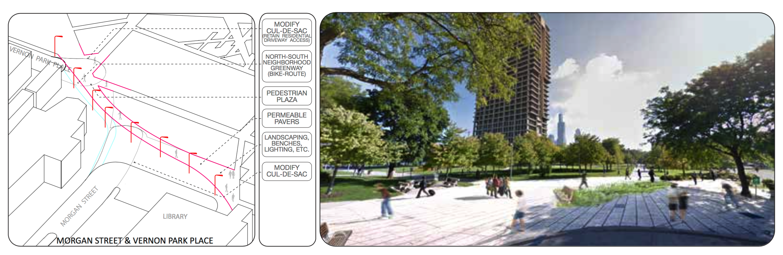
There's currently a cycling barrier where Morgan Street meets Vernon Park Place, at the northwest corner of the eastern portion of the campus. Over 16 years ago, the block of Morgan south of Harrison Street was eliminated to expand the campus. This removed the Vernon Park/Morgan intersection and eliminated motor vehicle traffic at pedestrian-heavy junction connecting University Hall (UH), the Behavioral Sciences Building (BSB), the Richard J. Daley Library, and the Little Italy/Tri-Taylor neighborhood to the west.
However, the sidewalks here are too narrow, creating a bottleneck, and they've been in disrepair for about a decade. Pedestrians and bicyclists are squeezed onto the same route and, in winter, the dilapidated sidewalks flood and freeze, creating an icy pond.
UIC intends to remove even more of Vernon Park and Morgan, creating a pedestrian plaza. They want to build separate walking and biking paths, and repair and streamline the sidewalk connection from the Behavioral Sciences Building to parts of campus southeast of there.
The Crossroads & Connections project would also improve transit facilities. The plan calls for new bus shelters and Bus Tracker signs, plus traffic signal coordination in order to speed up buses.
Lastly, C & C proposes modest upgrades to pedestrian crossings along Roosevelt Road, Taylor Street, and other roadways. These would include walk signals with countdown timers and leading pedestrian interval timing, which gives people on foot a head start before drivers get a green. Travel lanes and crosswalk markings would be re-striped as needed. Additionally, several unmarked crosswalks will be marked.
Despite its strengths, the plan doesn’t fully address underlying reasons why some of the intersections by UIC are so dangerous. For example, Halsted/Harrison has an extremely wide turning radius from eastbound Harrison to southbound Halsted. That encourages motorists to make fast turns at the location where many students are crossing to reach the 24-hour UIC-Halsted Blue Line station.
This intersection is undergoing changes during the Illinois Department of Transportation’s renovation and expansion of the Jane Byrne Interchange, but it unclear what modifications will be made. Halsted and Roosevelt has the same problem of wide turning radii on several corners. Here UIC plans more visible crosswalk markings, leading pedestrian intervals, and to install flashing yellow lights above crosswalks further down Roosevelt.
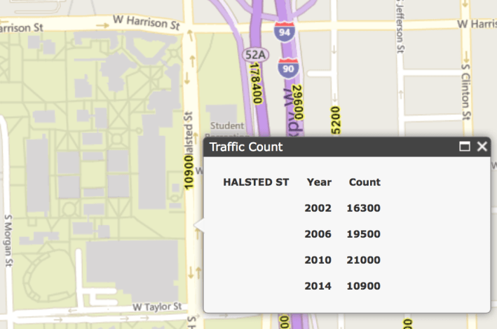
While Halsted has bike lanes between Harrison and Roosevelt, the plan acknowledges that motorists drive at high-speeds the four lanes, especially during evening hours. Converting Halsted from four lanes to two travel lanes plus a turn lane might be a good solution for calming traffic, but the plan states that this stretch sees 25,000 – 32,000 vehicles per day. That's too many for a four-to-three road diet, since the Chicago Department of Transportation generally won't do one on a four-lane street with over 20,000 trips per day.
However, it appears UIC's traffic numbers for Halsted are inaccurate. Illinois Department of Transportation traffic counts from the past decade put Halsted consistently below 20,000. In addition to overlooking the opportunity for a road diet, Crossroads & Connections doesn’t recommend any changes to the street to reduce speeding.
Roosevelt Road is also a high-speed four-lane street with conventional bike lanes and it's not a comfortable bike route, either. Taylor Street, two blocks north, is a good alternative – and marked as such with on-street signs – because it's a two-lane street with car speeds. However, like Milwaukee Avenue in Wicker Park, dooring is a hazard on Taylor because it's a narrow, busy retail district with high parking turnover. As part of the C & C plan, UIC is proposing protected bike lanes for Taylor east of Halsted, which would connect with PBLs on Canal Street, a few blocks east.
![]()
Did you appreciate this post? Streetsblog Chicago is currently funded until April 2016. Consider making a donation to help ensure we can continue to publish next year.