A new "Walk To Transit" initiative by the Chicago Department of Transportation will target 20 CTA stations for a slew of simple pedestrian infrastructure upgrades. People walking to several Blue Line stations on the west side and along Milwaukee Avenue, along with stations on the south and north sides, will see safety and usability improvements like re-striped zebra crosswalks, curb extensions, repaired or widened sidewalks, and new signage.
Suzanne Carlson, pedestrian program coordinator at the Chicago Department of Transportation, said at the Mayor’s Pedestrian Advisory Council meeting to weeks ago (theme: connectivity) that construction on a first phase of ten stations should begin in the spring of 2015. CDOT has grant funding for another ten stations, yet to be identified. She said that the designs [PDF] were published in March "at 30 percent," but only one minor design element has changed since then.
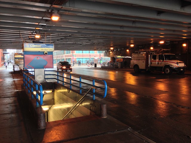
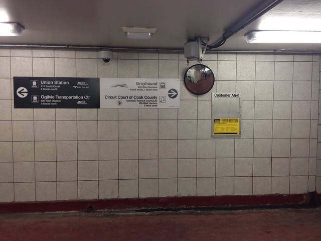
Some stations will get new and improved wayfinding signage. New signs outside the Blue Line's Clinton station, hidden underneath a Eisenhower Expressway overpass, will direct CTA riders to Metra, Amtrak, and Greyhound, and vice versa. Even among the majority of American adults who carry smartphones, figuring out where to go from the Clinton station can be a puzzle: The other stations aren't immediately visible from any of the station's four dark exits. Adding "breadcrumb" sign posts along the way would help. CTA and CDOT managing deputy commissioner Sean Wiedel have had conversations about adding Divvy wayfinding signs within stops like Clinton, where Divvy is similarly hiding around the corner from the station entrance, "but we haven't reached a definitive agreement at this point."
Above the Blue Line station at Grand-Milwaukee-Halsted, CDOT proposes reprogramming the signal with "leading pedestrian intervals," which will give people walking across the street a green light before drivers can make a turn. New curb extensions (bulb-outs) at Ohio Street, between the station and Milwaukee's bridge over the Ohio Street Connector, will slow down drivers and prevent them from driving down Milwaukee's faded bike lane.
Around the Pulaski Blue Line station in West Garfield Park, which is within the median of the Eisenhower Expressway, recommended improvements include curb extensions to slow turning drivers at all corners of Harrison and Pulaski, a pedestrian refuge island within Pulaski at Van Buren, and signs that will direct bicyclists to and from the station from Keeler Avenue -- a nearby "neighborhood route" under the Streets for Cycling 2020 Plan.
Outside the 63rd Street Red Line station in Englewood, new trees will enliven a dull corner at Princeton Avenue -- and also replace a dangerous gas station driveway, which eliminates the conflict between cars turning across the sidewalk into the gas station, right by a bus stop. Such dangerous curb cuts are not forever, since they have to be renewed annually.

Some of the proposals don't do enough to calm car traffic outside busy rail stations. Above the Division Blue Line station, for example, CDOT proposes to add a much-needed refuge island at Greenview to allow pedestrians to cross wide Division Street in two stages. But where Division meets Milwaukee, CDOT's proposal of repainting faded crosswalks does little to shield pedestrians from drivers making wide (and fast) right turns from Division onto Milwaukee. New curb extensions there could tighten the angle a bit, and require drivers to turn more carefully and considerately.
The stations that will benefit from the first round of Walk To Transit are:
- North/Clybourn (Red)
- Clinton (Blue)
- Central-Lake (Green)
- 63rd Street (Red)
- Pulaski-Congress (Blue)
- Grand-Milwaukee (Blue)
- Kedzie-Homan (Blue)
- Division (Blue)
- Kimball (Brown)
- 35-Bronzeville-IIT (Green)

