Wells-Wentworth Project Will Fix Intersection, Spark Riverfront Development
For years, Chinatown has welcomed visitors with a red ceremonial gateway straddling Wentworth Street just south of Cermak Road. Yet for many visitors to Chinatown, accessing the historic Wentworth business strip involves confusedly jaywalking across the six lanes of Cermak, a not-so-welcoming experience.
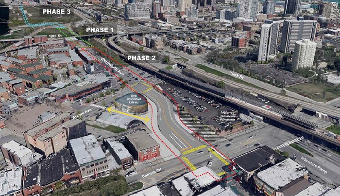
The Wells-Wentworth Connector project aims to make that tricky intersection safer and less puzzling, while also opening up access to a large expanse of riverfront that’s been fallow for decades despite sitting almost in the Loop’s shadow.
Currently, as you head south on Wentworth, the street jogs west at Cermak. Wentworth will be widened and rerouted, so that the westward shift happens north of the intersection. The street currently terminates at a railroad line around 16th Street, just south of the vacant land and east of Ping Tom Park. The road will be extended further north and one block west, under Roosevelt Road, linking up with Wells Street near River City.
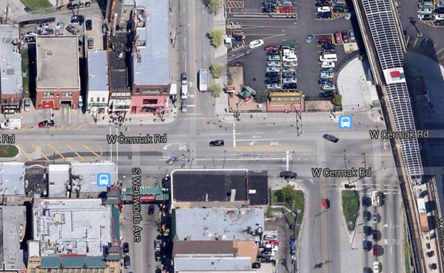
The intersection redesign will widen the asphalt expanse at the Chinatown Gateway, and level the three buildings that today house the closed New Three Happiness and Cantonesia restaurants, as well as the International Bank. From there, Wentworth, shown on renderings as being two to four lanes wide with protected bike lanes, will curve back east, slaloming around a new teardrop-shaped library at Archer Avenue. Wentworth will follow its existing route north past the Chinatown Square development and up to 18th Street.
From 18th, what’s now a softball field’s dirt parking lot will be paved and widened, and a new road alignment will be built from Ping Tom’s eastern edge across the railroad tracks and north to Roosevelt, where it will connect with Wells along the west side of the Roosevelt Collection retail and residential development.
This project was contemplated as far back as the 1909 Plan of Chicago. At Wednesday’s City Council meeting, Mayor Emanuel introduced an ordinance to purchase the three buildings on Cermak and to allocate money from two tax increment financing districts to bankroll the $62 million project. He said the work is slated to begin later this year and continue through 2015.

In a press release [PDF], Emanuel insisted that the plan will “increase the safety for motorists and pedestrians at the busy intersection in the heart of this great neighborhood.” While at first glance, widening Wentworth from two to four lanes doesn’t seem like a pedestrian-friendly move, the reconfiguration should reduce crossing distances for most people on foot. That’s because a new crosswalk at the east leg of the junction will finally allow people to walk directly between the local Red Line stop and the traditional Wentworth business strip, without having to cross two streets.
Similarly, it will be sad to lose the three old buildings at the northwest corner, but adding land to the northeast corner, currently a small parking lot, will encourage redevelopment of the space. Up the street, the new library will include a plaza that will allow a diagonal pedestrian shortcut to Chinatown Square, the newer retail area. Crews will stripe a crosswalk will on Archer to facilitate that shortcut, and build sidewalks along Wentworth from 19th Street up to the new Ping Tom Park field house.
North of Chinatown, the connector will fill a hole in the city’s grid: there are currently no north-south through streets connecting Cermak and Congress Parkway between Wells (200 west) and Canal (600 west), even though the intervening area is filling in with high-density development. The connector will be an at-grade access road through the spotty landscape of high-rises and vacant former rail yards that line most of the river’s east bank in this area, potentially spurring development.

The most conspicuously underutilized land in this part of town is the 62-acre rectangle between Roosevelt, Clark, 16th, and the river, dubbed the “Riverside District” by its former owner, disgraced businessman Tony Rezko. Formerly a CSX rail yard and, before that, a bottleneck-creating bend in the river, the site may soon be purchased by the city to expedite its redevelopment. Until now, efforts to develop the land have been fruitless, largely because the land sits within a bowl between elevated Roosevelt Road on its north, railroads and the river. At-grade access will make the land much more attractive to developers.
Indeed, because of the “renewed interest in this [development] project now… we are moving forward with the [road] plan,” CDOT spokesman Pete Scales told the Tribune. The city plans to complete the first two phases of the project, covering the area between Cermak and Ping Tom, by 2016. Construction of the new road north of the park will be “coordinated in conjunction with a future mixed use redevelopment agreement,” Scales said.

Read More:
Streetsblog has migrated to a new comment system. New commenters can register directly in the comments section of any article. Returning commenters: your previous comments and display name have been preserved, but you'll need to reclaim your account by clicking "Forgot your password?" on the sign-in form, entering your email, and following the verification link to set a new password — this is required because passwords could not be carried over during the migration. For questions, contact tips@streetsblog.org.