The Chicago Riverwalk extension, from State Street to Lake Street along the south bank of the waterway, will be a marquee public space and recreation project in the same class as Millennium Park and the Bloomingdale trail and park. And like the Bloomingdale, the riverwalk also has the potential to be a valuable addition to our city’s car-free transportation network.
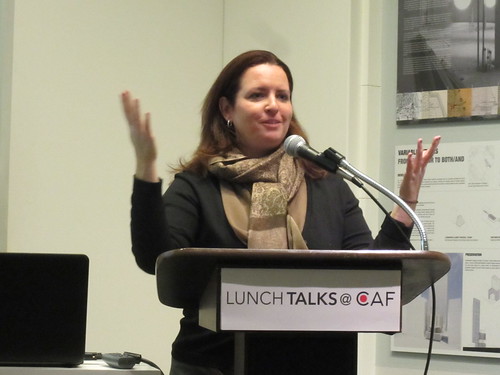
Chicago Department of Transportation project manager Michelle Woods outlined the $90-100 million riverwalk plan at a community meeting yesterday at the Chicago Architecture Foundation. The current design assigns a unique theme and function to each of the six blocks between State and Lake, with the bridges over the river serving as boundaries between the different sections, Woods said.
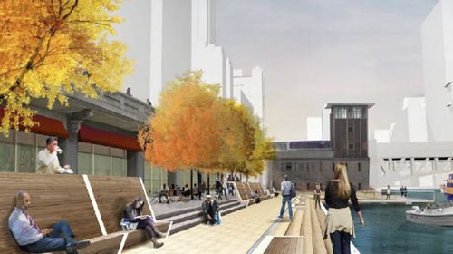
“The Marina” (from State to Dearborn) would have retail space and public seating, while “The Cove” (Dearborn to Clark) might feature kayak rentals and docks for other human-powered watercraft. “The River Theater” (Clark to LaSalle) would be a series of steps leading down from Wacker Drive, which could double as audience seating for a floating stage.
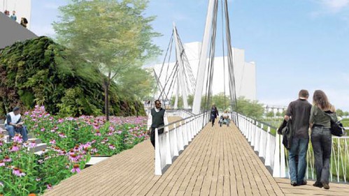
“The Swimming Hole” (LaSalle to Wells) would feature a water play area for kids, perhaps a “zero-depth” fountain similar to Millennium Park’s Crown Fountain. “The Jetty” (Wells to Franklin) would offer fishing piers and floating gardens, and “The Boardwalk” (Franklin to Lake) would be the site of an artistically designed bridge that would bring visitors from Wacker down to the riverwalk level.
To fund this ambitious project, CDOT recently sent a letter of interest to the US Department of Transportation for a loan through the Transportation Infrastructure Finance Innovation Act program. And, as with the Bloomingdale, the city is looking for private sponsors to help bankroll ongoing maintenance and programming on the riverwalk. If CDOT is invited to apply for the TIFIA loan soon, construction on the section from State to LaSalle could start as early as this summer, Woods said. “I’m aggressively optimistic.”
After the floor was opened to questions and comments, Michael Riordan, president of the River North Residents Association, brought up the subject of the riverwalk’s potential as a commuting route for people on foot and bicycles. Here's a transcript of the discussion.
Michael Riordan: I can see this as being a pedestrian commuter route for people who live and work in the Loop. I walk to work as much as possible and I think it will be a terrific amenity. [Riordan added that he’d like to see an extension of the existing river path along the North Branch from Chicago Avenue to Erie Street, leading south to the riverwalk.] And I was hoping that your design would incorporate some kind of connection that will allow people to take the riverwalk from the lakefront to Franklin Street, and then take Franklin to the Wolf Point development, and up along the North Branch.”
Michelle Woods: What you’d be able to do is walk down to the riverwalk at Michigan, continue along and then come up the steps at Franklin and cross over the river. Or you could go up at Lake Street if you wanted to go to the Ogilvie [Transportation] Center.
MR: Are you incorporating bicycles into this?
MW: [The riverwalk is] technically not wide enough to be a bike path. But what I anticipate is that early in the morning, commuters that use the Lakefront Trail will probably use it as a bicycle path, which frankly I am fine with them doing provided it’s not ten o’clock in the morning and filled with families and people who are using it.
MR: Provided it doesn’t become a Grand Avenue and Lake Shore Drive kind of mess.
MW: Exactly. We’ve become almost the victims of our own success in that the Lakefront Trail is so incredibly popular you almost can’t use it because it’s too crowded. So we want to be careful about things like that. What I’m encouraging bikers to do is, once they come to the west side of Michigan, is take the driveway from the old ward yard [up to Wacker at Wabash Street]. That’s a nice easy transition area to the street grid.
As the department of transportation, we want to promote connectivity for transportation amenities. If you came downtown on Metra, where would be a good spot for a water taxi dock [on the riverwalk]? Where are the connections to bus routes to an ‘L’ station? We’re coming out with bike share soon. Where would be a good spot for a bike share [kiosk]? So there’s a lot of opportunity.
MR: [Suggests building a bridge from Wolf Point to Lake and Canal streets that would provide a shortcut for people walking to the Ogilvie Center and Union Station.] If that could be incorporated in some way with the bridge you’re designing at Franklin Street, that would be a really neat opportunity to create something like the Millennium Bridge in London.
View Chicago Riverwalk Extension in a larger map
Riverwalk area shown as blue line; Riordan's proposed bridge is orange line.
MW: Are you saying you don’t like my existing bridges? [Laughs.]
MR: No I like your existing bridges. I like where you’re going, but think bigger thoughts. And don’t think just south side of the river. Think about how you’re going to connect all those people that live on the north side of the river who work on the south side of the river, and all those people that are using the riverwalk as a pass-through to get from Michigan Avenue, Streeterville and Northwestern Memorial Hospital to the train stations.
MW: Like I said, those connections are critical and we have been challenged to figure out ways we can promote them and make them easier for people.


