Miracle on Ashland Avenue: Despite past pushback from neighbors, bus line will be extended north to Ravenswood Metra
Update 5/28/24, 3:40 PM: Today 47th Ward Chief of Staff Joshua Mark told Streetsblog that the new bus service on Ashland north of Irving Park will be launched in the late summer. “I’ll let CTA share the date at the meeting.”
They said it couldn’t be done! And to be honest, I was a little skeptical myself.
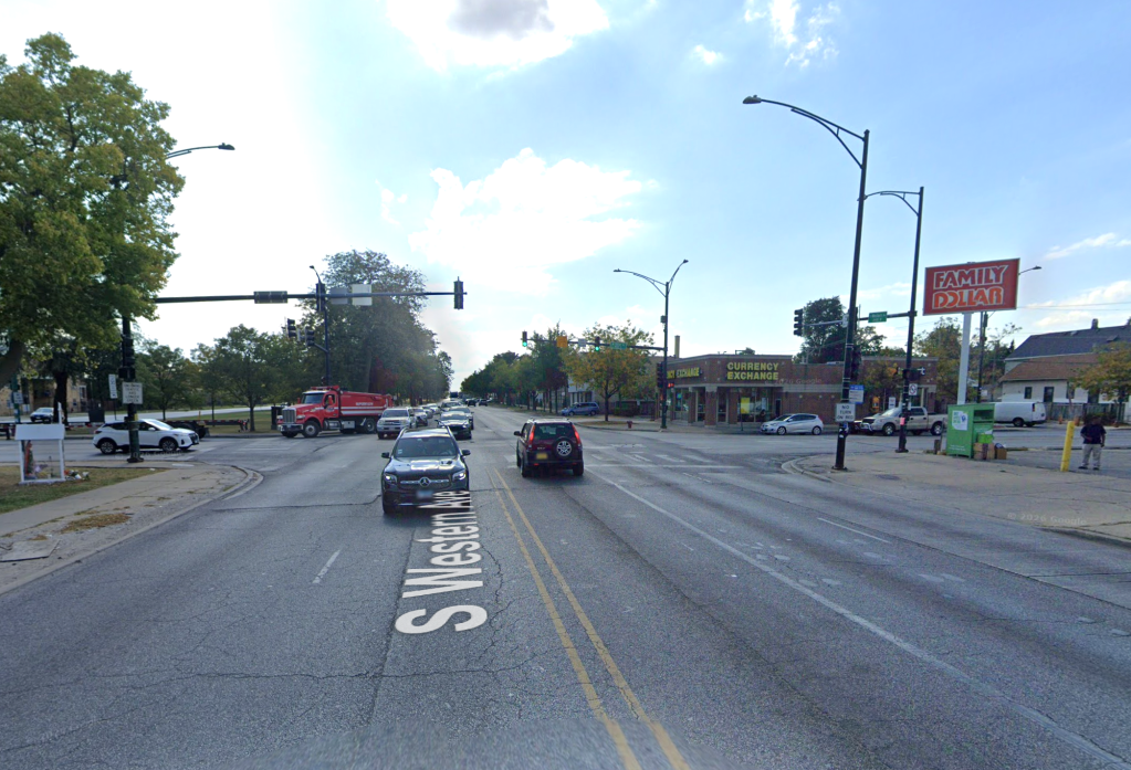
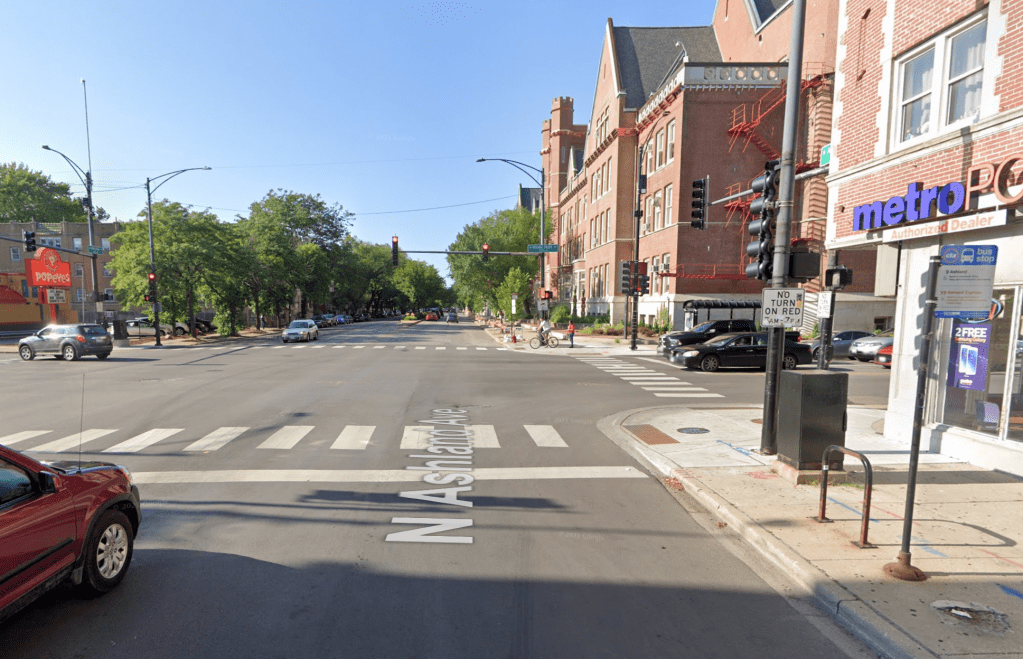
It seemed highly unlikely that Chicago would ever extend the Ashland Avenue [1600 W.] bus corridor further than its current northernmost stop on Ashland at Irving Park Road [4000 N.] Some neighbors north of Irving have long opposed converting a few car-parking spots on the avenue to bus stops. They also made dubious claims that CTA traffic would damage their homes’ foundations. Read more about that issue at the end of this 2013 Streetsblog Chicago article.
But on Friday, local Ald. Matt Martin’s (47th) newsletter announced that the dream is becoming a reality.
So how did this victory for straphangers come to be? Ald. Martin’s chief of staff Joshua Mark provided some background in the following discussion. We talked last week, but the ward asked Streetsblog to hold off on publicizing the news before it was shared with constituents. The interview has been edited slightly for clarity and brevity.
Joshua Mark: [During an interview for another recent piece on the new campaign for bus rapid transit on Western Avenue (2400 W.)] We have gotten the CTA to extend the Ashland bus north on Ashland.
John Greenfield: OK cool. [It took a moment for the significance of that statement to kick in.] Wow! How the heck did you do that? There were so many neighbors who were dead-set against it. Aren’t people going to complain about losing car parking spots and ruining their foundations? How were you able to do something about that? Are there enough people living on Ashland north of Irving nowadays who want bus service?
JM: Yes, there are a lot of people living on Ashland who want it. We have not encountered any public push-back.
JG: Terrific. Please tell me more about the plan.
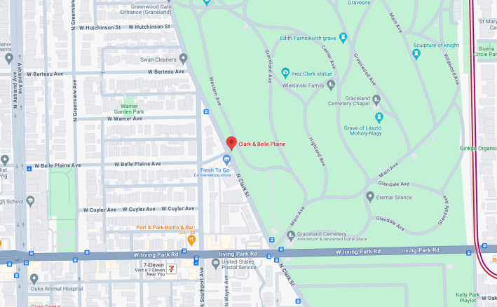
JM: Obviously the Ashland bus currently does not go north of Irving Park. It instead makes a right on Irving and then terminates on Clark Street [about 1400 W. here] and Belle Plaine Avenue [4100 N.] It currently terminates in front of Graceland Cemetery.
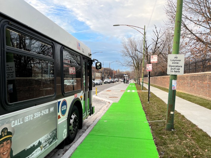
The CTA has found that, although they’re making it work, the current layover with the [protected/raised] bike lane on Clark [at Belle Plaine], they don’t love it. It’s a little too narrow and it’s a little too much work. They were interested finding another place for their layovers.
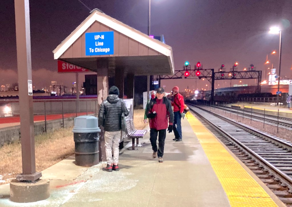
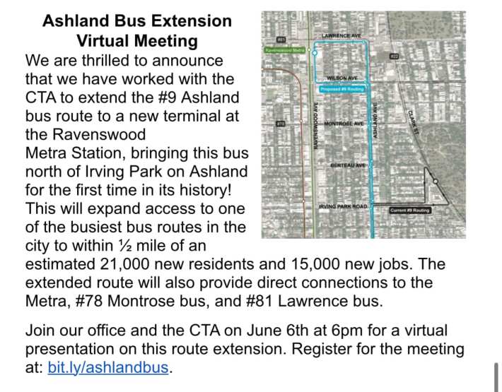
We worked with them to identify a location for a new layover zone. So we eventually landed with them on extending the bus route to the Ravenswood Metra station. What this would mean is that the CTA bus will go north of Irving Park. It will go until Wilson Avenue [4600 N.] It will take a left on Wilson. Then it will take a right onto Ravenswood Avenue [1800 W.] and it will terminate in front of the Metra station.
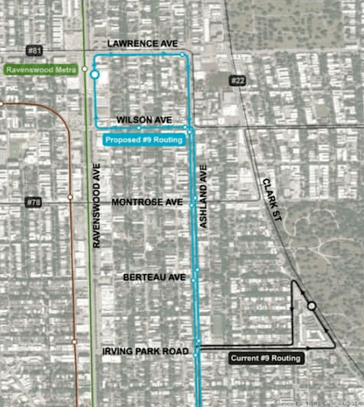
This is not a massive extension of the route further north. It is around a mile. And this is fully within our ward. I would have, of course, loved for the CTA to agree to extend it further, but this is where they were willing to go. And we think the new route will not make a world of difference, but it will make a big difference for those who are impacted.
The CTA calculates that an additional 21,000 residents are going to now live within a half mile of the Ashland bus, which is obviously a huge change. And the Ashland bus is going to come now to within a half mile of an additional 15,000 jobs. It is going to allow for connections between the Ashland bus and the 78 Montrose bus, as well as the 81 Lawrence bus at the Metra station.
That’s not to mention the connection to the Metra station itself, meaning that the bus will unlock a new commuting pattern for anyone heading downtown. If they live, say, near Lakeview High School [at Irving Park/Ashland], they could now get downtown by taking the Ashland bus north to Metra and then taking the train down if they wanted to. And, of course, it allows folks to go north on Metra to Ravinia or Waukegan.
JG: Where will the bus stops be?
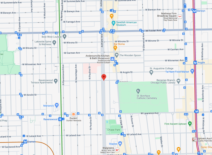
JM: [Heading north on Ashland] there will be a bus stop at Irving Park, a bus stop at Berteau Avenue [4200 N.], and at Montrose, which will allow folks to have new access to businesses, including restaurants. For example, there’s a Venezuelan place [BienMeSabe, 1637 W. Montrose Ave.]
Then there’s going to be a stop on Wilson and Ashland, where the bus makes the left. And there will be a stop at Wilson and Hermitage Avenue [1700 W.] And that will be it until the terminus at the Metra station. The layover zone is going to be between Leland Avenue [4700 N.] and Lawrence on the east side of Ravenswood, by the [ExtraSpace] storage facility.
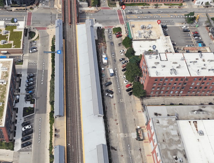
The bus is going to stop very much in the middle of the block. Obviously a layover zone involves multiple buses. So it will take over one side of the street, the southern half. People will get out and they will be in the middle of the block. Depending on where they get off, they could enter the Metra station on either side.
JG: Then what will the bus driver do?
JM: That’s the end of the line. So the new run will go north on Ravenswood, it will take a right on Lawrence, and then take another right to head south on Ashland. They’re doing bus stops at every other block [a quarter mile between stops], so southbound it’s going to be Lawrence, Wilson, Montrose, Berteau, and then Irving Park.
I’ve been speaking to neighbors’ associations to give them a heads-up. Personally, I used to live on Ashland north of Ainslie Avenue [4900 N.], so I would have take to Divvy [bike-share] down to the Divvy station at Ashland and Belle Plaine and then walk to Ashland and Irving to catch the Ashland bus.
When I lived near Ashland and Ainslie, I had neighbors tell me we lived in a transit desert. That is a laughable statement when you consider that Ainslie is two blocks south of the Foster bus, one block west of the Clark bus, three blocks northeast of the Ravenswood Metra station, and two blocks north of the Lawrence bus.
I still thought it was significant for people to say that, because when you’re looking for that north-south connection, it is really an exception in Chicago to live off of a major street like Ashland and to not have access to a bus. And it makes it more difficult to have that easy north-south connection. [Clark Street runs northwest-southeast, so 2.25 miles south of Ainslie at Barry Avenue (3100 N.), Clark is located a mile east of Ashland at Halsted Street (800 W.)]
It’s going to make a big difference for people and, in addition to just extending the line to more folks, it’s about giving access to more places. As it stands, the bus layover zone is really in a no-man’s land. It’s in front of a vacant 7-11 (although that 7-11 may be reused soon, if you’ve been following the 46th Ward zoning process). It’s in front of a cemetery. If you draw a circular line around the stop, that means that half the catchment area is not [living] people, it’s a cemetery.
So we’re bringing it to more people, but it also means that the bus line ends at the Metra station, at the Lawrence bus, at the Mariano’s [supermarket], at LA Fitness, McPherson elementary school is nearby, and there are bars and businesses. It’s really about expanding what the Ashland bus can take you to.
You can attend the online-only community meeting on the project on Thursday, June 6 at 6 PM. Register for the info session here.

Did you appreciate this post? Please consider making a tax-deductible donation.

Read More:
Streetsblog has migrated to a new comment system. New commenters can register directly in the comments section of any article. Returning commenters: your previous comments and display name have been preserved, but you'll need to reclaim your account by clicking "Forgot your password?" on the sign-in form, entering your email, and following the verification link to set a new password — this is required because passwords could not be carried over during the migration. For questions, contact tips@streetsblog.org.