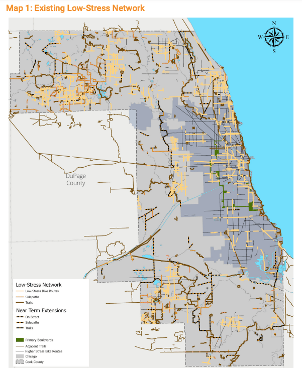
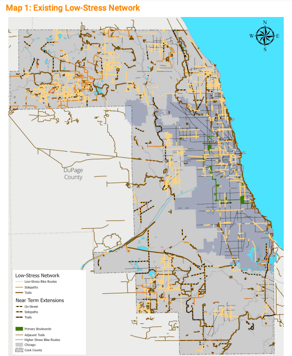
Last week, Cook County released its first ever Bike Plan, charting a path for safer and more plentiful bicycle infrastructure across the county. The plan calls for hundreds of miles of new low-stress bike paths: 90 miles of new off-street paved trails, 150 miles of new side paths and 230 miles of new low-stress on-street routes, including quiet residential streets and protected lanes. According to the plan, this upgrade would place 96 percent of Cook County residents less than a mile from a low-stress bike route.
The Cook County Bike Plan was inspired by the county’s Invest in Cook grant program, according to Jesse Elam, director of strategic planning and policy for the Cook County Department of Transportation and Highways (DoTH.) In a written interview with Streetsblog, Elam said the Invest in Cook program, which funds a range of transportation projects, received more applications for bicycle and pedestrian improvements than any other project type. “That is one of the reasons we decided to develop a broader strategy to meet the needs of people who bike and people who would bike if they had safe and comfortable routes.”
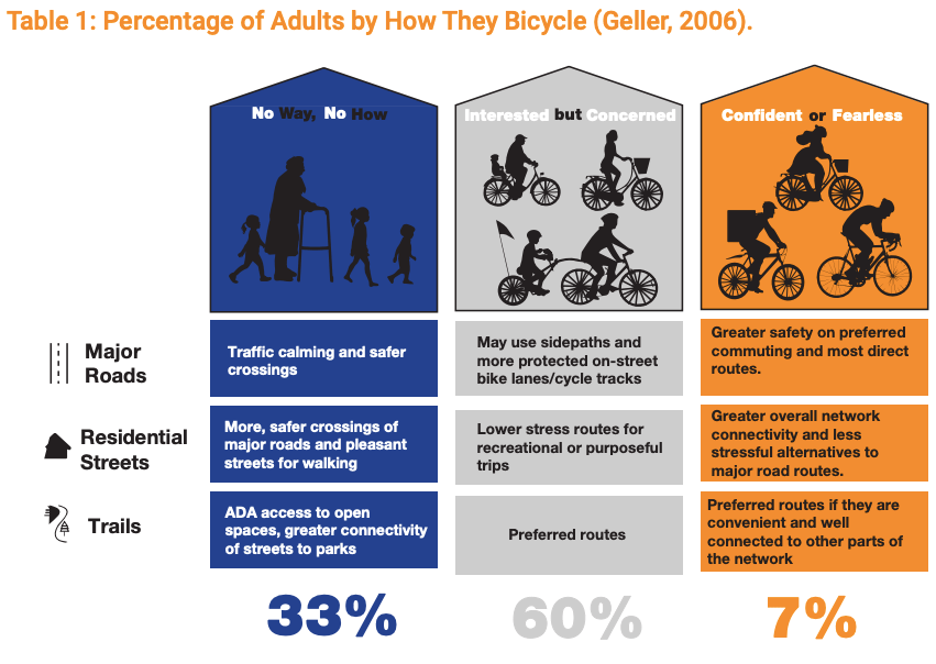
Safe and comfortable routes in Chicagoland don’t often connect people on bikes to their destinations. The county plan focuses on how DoTH can play a role in connecting scattershot bikeways that start and stop abruptly—usually at the border of jurisdictions. Advocates agree that a protected, connected bicycle network is the best incentive for current riders to make more trips by bike and encourages cautious, potential riders to try using two wheels for their next journey. According to the county plan, 60 percent of survey respondents said they would bike more if they had access to low-stress bike facilities. The plan categories bike facility users into three groups—including those who exclusively walk or use mobility aids—and charts improvements to roads, streets and trails that would most benefit each group.
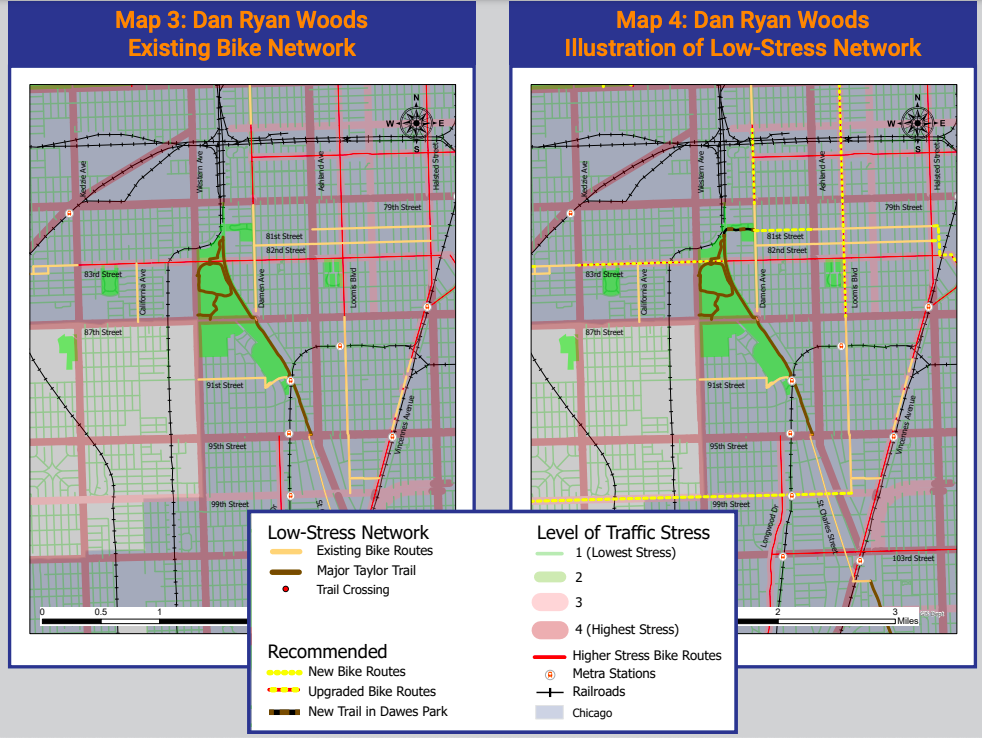
Along with building new bike infrastructure on DoTH roadways, the county promises to lead and help fund feasibility studies for off-street trails outside their jurisdiction, support city-level planning for residential streets, and improve safety for pedestrians and bicycles at intersections, where most crashes occur. Safety improvements where city streets cross DoTH roads would also help sew up gaps in the bike network. The plan cites the Major Taylor Trail as an opportune spot to connect on-street bike paths with off-street trails. Maps illustrate how improved bike lanes on 83rd, Loomis and Damen would connect the Major Taylor Trail with the surrounding neighborhoods and create bikeable paths to suburban Evergreen Park and Oak Lawn.
The plan is the result of a yearlong planning process with the Transportation Equity Network, a coalition of advocates for racial equity and mobility justice in transportation planning. In an introductory letter, Cook County Board president Toni Preckwinkle notes the paucity of bike facilities in low-income and under resourced neighborhoods, stating that bicycle and pedestrian projects in these areas will be prioritized. One huge step in an equitable direction is the announcement that the county will no longer require municipalities to contribute to design and construction costs of bike infrastructure on county roads—a policy that ensured lower-income communities forced to make tough budget choices would have inferior infrastructure to wealthy areas with more tax revenue.
Alex Perez, advocacy manager at the Active Transportation Alliance, said that removing this funding requirement will also speed up the pace for bike facility projects to complete construction. The county also pledges to assist high-need communities with securing funding for bike infrastructure maintenance like sweeping, snow clearing and surface repairs.
Extensive collaboration between many players—134 municipalities, 80 park districts and 20 townships—will be required to bring this plan to life. Elam said the speed of implementation hinged on many factors from funding availability to partner capacity to road work schedules, and the construction of almost 500 miles of new bikeways will take “sustained effort for more than a decade.” The final pages of the plan lay out action steps for the next two to three years including bike network studies, feasibility assessments, sponsoring outreach and engagement activities, and partnering with communities to designate routes and intersection improvements. Perez from ATA said, “Working with two communities per year to identify new routes is a great strategy to work with community organizations and residents to address gentrification and displacement.”
Read the full Cook County Bike Plan here.
