Cook County transportation department wants input on biking in the large area around Lake Calumet
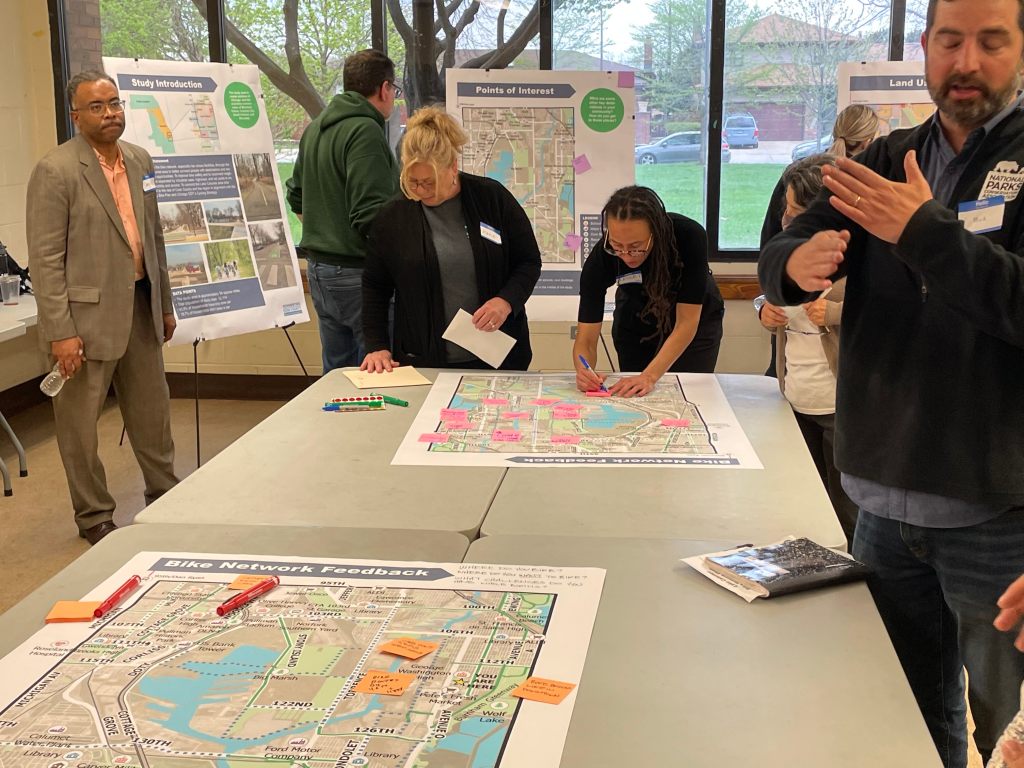
The Lake Calumet Bike Network Study by the Cook County Department of Transportation and Highways (CCDoTH) held its first public input meeting at the Rowan Park Field House. Attendees could learn about the project on poster boards around the room; county staff and consultants were there to answer any questions.
The goal of the project is to find ways to connect destinations and recreational opportunities, improve safety for bicyclists, and reconnect neighborhoods separated by industrial uses, highways, and rail yards that litter the area.
The Bike Network Study area is 34 square miles, including parts of Chicago and the surrounding suburbs of Burnham, Dolton, Calumet City, South Holland, and Riverdale. The total population looked at is approximately 12,114. Of that number, 43.8 percent of households have one car, while 18.7 percent of households don’t have access to a vehicle.
Project managers were also collecting information about which destinations people use and how they get there. Such as schools, major employers, civic buildings, recreation, supermarkets, public housing, hospitals, and transit facilities. The key points of the study were the schools, civic buildings, and supermarkets on the outer edge, with the large manufacturing employers and parks in the middle. Though several locations were already marked, attendees added information via sticky notes to the board as well.
Another section of the room focused on land use, where a board stated that a “bike network should allow people to travel to and through residential and industrial areas.” The study area is 37 percent transportation, roads, and utility uses, 22 percent residential, 16 percent industrial, 14 percent open space, five percent vacant land, three percent institutional, and three percent commercial. The key points outlined were the higher percentages of industrial, transportation, and open space land uses than the whole of Chicago and the pockets of low and medium density residential.
One board showed “Street Grid & Sidewalks”. The Lake Calumet area has many major streets without sidewalks or only have them on one side of the road, and a map showed the inventory of sidewalks. Project managers were showing that there are fewer continuous E-W and N-S streets than in other parts of the city, greater truck traffic on major arterials because of the industrial concentration, and they have some of the widest streets in the region.
Traffic safety was another topic discussed at the meeting. Since 2019, 38 people have died in traffic crashes inside the Bike Network Study area. Additionally, four pedestrians and cyclists were killed in the study location within the same time frame, with a map outlining the vehicle passenger fatalities, bike or pedestrian fatalities, and bike and pedestrian injuries.
Maria Miramontes, a resident attending the meeting, said that, “I think that everybody should be made more aware of the safety concerns. Because drivers are not careful and they don’t look out for bikes and also even just pedestrians on the trail.”

Meeting graphics also showed that the project “will identify opportunities to expand the bike network with the goal of every resident being within ½ mile of a low stress bike facility.” Areas of improvement already proposed are Lake Calumet & Big Marsh Trails, Burley Avenue Sidepath, 118th Street Burnham Greenway Connector, Burnham Greenway extension, Cal-Sag Trail East, and Calumet River Trail.
Alex Perez, an advocacy manager at Active Transportation Alliance, said, “Definitely one important thing is getting community feedback, making sure that you’re involving the community with the suggested routes where the bike lanes are going to be going.” The second important planning aspect, Perez said, “is making sure that you’re not putting bike lanes on heavy routes, especially with heavy round traffic, with the community being such a heavy industrial area.”
Finally, the meeting detailed the proposed 118th Street Burnham Greenway Connector, which would link the proposed Burley Ave sidepath and Ewing Ave with the Burnham Greenway via a protected two-way bike lane on 118th St. The key points would be to maintain a single travel lane in each direction while also having parking on the north curb. The south parking lane would have a curb-separated two-way bike lane. Additionally, the project would create an accessible trailhead access to the Burnham Greenway.

Wayne Garritao attended the meeting and said, “[I learned] that there’s plans to do a lot of things. Hopefully I’ll be alive to see a lot of it, because if half of this stuff gets done, then it’ll improve so many things. People who don’t have cars can now either walk or bike. It’s going to cut down on pollution if people are using bikes and walking. It’s going to make it easier for a lot of people that are on the far southeast side which is not one of your wealthier communities.” Garritao added that they believe more people would walk or bike “if they had clear access on a path rather than maneuvering amongst cars and trucks,” which is “dangerous” right now.
Benet Haller of CCDoTH said that the department’s next step after the meeting is compiling the information they received and prioritizing locations where the gaps are the worst. Haller also said that they’d also have more sessions in the future for residents to attend and allow their thoughts to be heard about the project.

Streetsblog has migrated to a new comment system. New commenters can register directly in the comments section of any article. Returning commenters: your previous comments and display name have been preserved, but you'll need to reclaim your account by clicking "Forgot your password?" on the sign-in form, entering your email, and following the verification link to set a new password — this is required because passwords could not be carried over during the migration. For questions, contact tips@streetsblog.org.