Translating the CTA ‘L’ train map into bike routes
Today I was rummaging around for envelopes to mail copies of my book to Streetsblog Chicago donors (thanks donors!), when I came upon a silkscreen print that I bought at an art fair years ago, but never got around to framing.
I don’t know who the artist is, since the poster is only signed with this symbol. But maybe someone who’s familiar with them will see this post and shed some light on the subject.
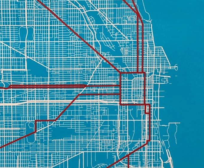
The poster takes the Chicago Transit Authority’s ‘L’ train map and replaces the different branches (within the central city) with bikes routes, most of which are fairly rideable streets. They’re not radically different than the proposed “Spoke Route” bike superhighways (dark blue on this map) identified in Chicago’s Streets for Cycling 2020 Plan.
First, here a reminder of what the CTA train line routes look like.
And here’s the print with bike routes mirroring the ‘L’ lines.
Below is a breakdown of the bike itineraries, generally heading towards downtown.
Loop ‘L’ tracks
- Kinzie
- Desplaines
- Harrison
- Dearborn
Green Line (East 63rd branch)
- Cottage Grove
- 60th
Green Line (Ashland Branch)
- Wood
- Garfield
Red Line South
- King
- 31st
- Princeton
- 29th
- Canal
- Archer
- State
- 18th
- Wabash
- 9th and Plymouth (northbound)
Orange Line
- 59th
- Kostner
- Lawndale
- Archer
Pink Line / Blue Line (Forest Park Branch) Hybrid
- Cermak
- Kostner
- Archer
- Ogden
- California
- Roosevelt
- Ogden
- Jackson
Green Line (Harlem/Lake Branch)
- Washington (two-way west of Garfield Park)
- Washington (westbound between Garfield and Union parks)
- Warren (eastbound between Garfield and Union parks)
- Randolph (westbound east of Union Park)
- Washington (eastbound east of Union Park)
Blue Line (O’Hare Brach)
- Higgins
- Milwaukee
Brown Line
- Lawrence
- Damen
- Addison
- Lincoln
- Wells
Red Line North
- Clark (that’s it)
What do you think of this bike route approximation of the ‘L’ system? Would you tweak the itineraries to make them more rideable, or make them better approximate the train lines?

Read More:
Streetsblog has migrated to a new comment system. New commenters can register directly in the comments section of any article. Returning commenters: your previous comments and display name have been preserved, but you'll need to reclaim your account by clicking "Forgot your password?" on the sign-in form, entering your email, and following the verification link to set a new password — this is required because passwords could not be carried over during the migration. For questions, contact tips@streetsblog.org.