Update 4/2/20: Craig L. Kaiser, a retired business person and longtime Streeterville resident who founded the community group Streeterville Neighborhood Advocates has sent out the following message:
Streeterville Neighborhood Advocates seeks to educate and engage residents on safety and quality of life issues in our neighborhood.We want you to be aware that there is a project underway to widen Mies Van Der Rohe way between MCA and Seneca Park in order to incorporate a southbound turn lane. We are opposed to this project and would like the city to conduct a public hearing to provide the community with more insight and allow us to express our opinion on its merits.Our concerns are that this project will:1- Take land from Seneca park, removing the sidewalk, green space and old growth trees.2- Expedite outside traffic flow into Streeterville, one of the most densely occupied and gridlocked neighborhoods in the city.3- Impact pedestrian safety by accelerating traffic volume and speed.4- Encourage a car-centric culture when urban communities are moving to pedestrian-centric transit.5- Consume at a minimum, $380,000 of our hard-earned tax dollars.Regardless of how close you live to Seneca, this is your park, your community and your tax dollars. If you would like to join a small team to develop a plan to secure a public hearing, please contact us at SNA60611[at]gmail.com.
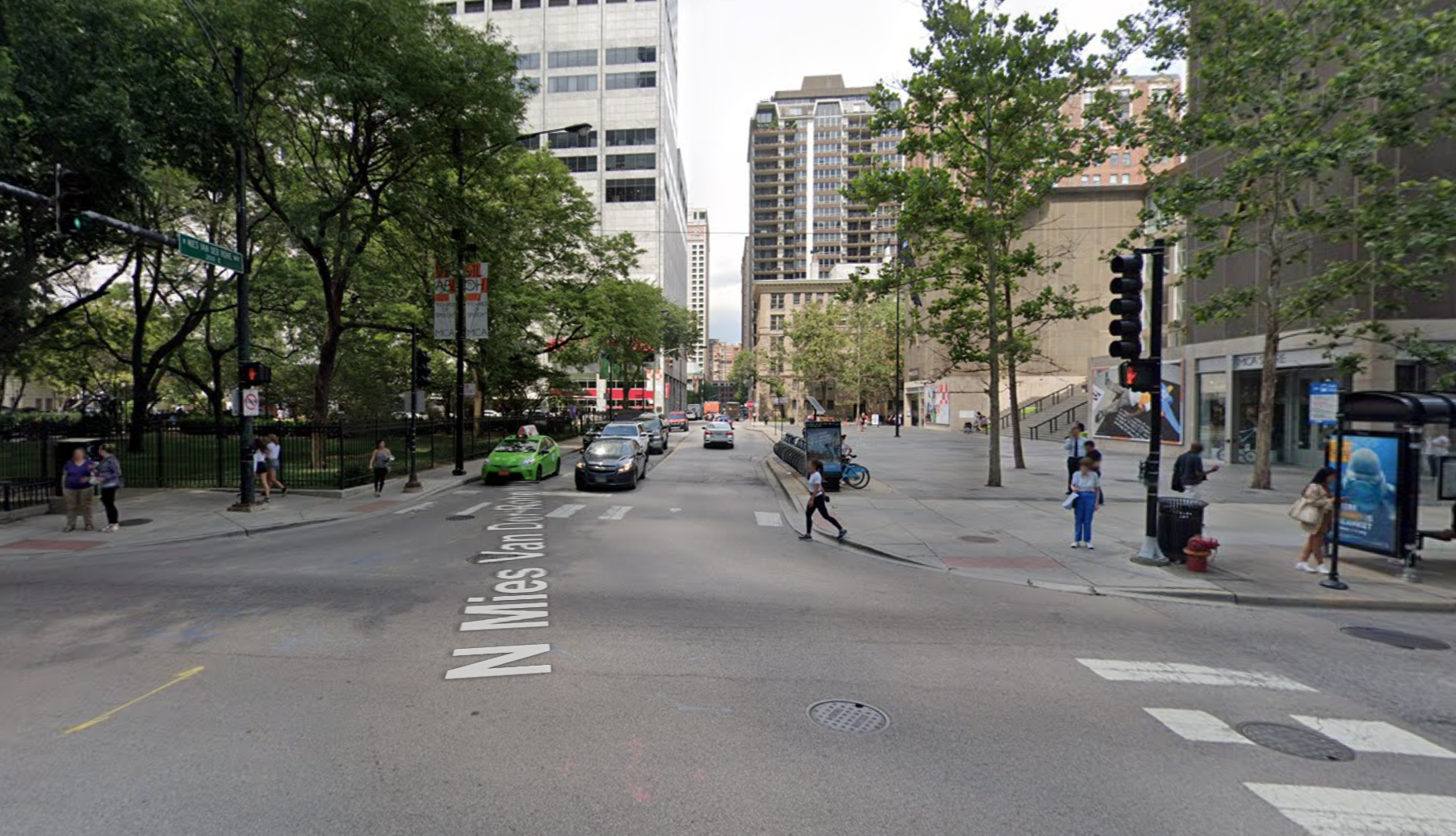
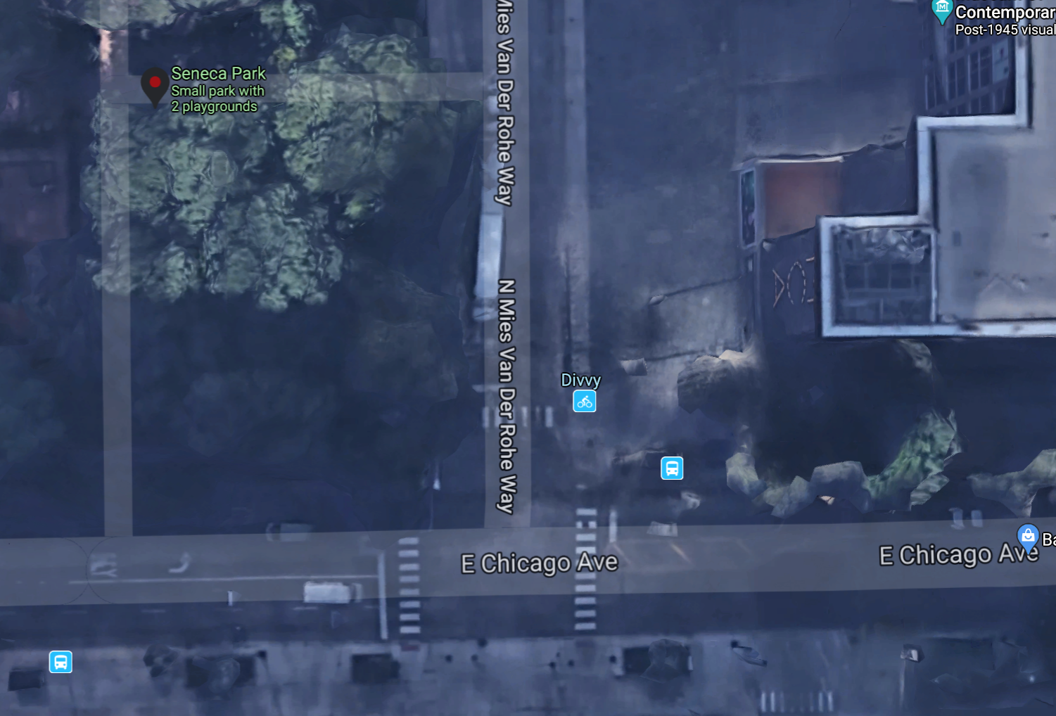
Streeterville, the downtown neighborhood roughly bounded by the Mag Mile, the Chicago River, and Lake Shore Drive, doesn't have tons of green space, but the city's plan to carve up a small park across the street from the Museum of Contemporary Art moves forward, a chunk of lawn will be replaced by asphalt.
Seneca Park is a one acre facility with a playground located across from the museum at the northwest corner of the T-shaped intersection of Chicago Avenue and Mies Van Der Rohe Way, named for the celebrated German-American minimalist architect. 2nd Ward alderman Brian Hopkinsrecently got an ordinance passed in City Council to widen the Miesian thoroughfare by three feet to make room for a left turn lane southbound drivers heading east towards LSD. That means the park would lose a three-foot strip of land.
Neighbors I've heard from say Hopkins claimed he vetted the project with the community, but it appears he only mentioned the project in a couple of unrelated public meetings.
The Chicago Department of Transportation spokesperson said in a statement that the turn lane project is estimated to cost $380,000, and claimed the purpose of the turn lane is not to make driving easier by giving left-turning drivers a place to wait out of the way of right-turning motorists, but rather "the goal of this project is to improve pedestrian safety."
"Over the last decade, CDOT through the offices of [42nd Ward alderman Brendan] Reilly and Hopkins, has received numerous complaints from area residents regarding vehicular congestion caused by southbound traffic on Mies Van Der Rohe from Chicago to Pearson," CDOT stated. Wait, what? Aren't you just talking about an inconvenience for drivers here?
"CDOT reviewed available data and conducted several site visits, and confirming that southbound traffic often backs up to Pearson [the next block north of Chicago Avenue]/Mies and blocks both the intersection and the crosswalks," the statement continued. Oh, OK, that's how the city is justifying this as a pedestrian safety project.
"This heavy congestion has also created pedestrian safety concerns as a result of conflicts between the heavy southbound left turns [towards LSD] at Mies/Chicago and the pedestrians crossing the east leg of [the intersection,]" CDOT said. "During rush hours, approximately 300 vehicles make southbound to eastbound left turns at Mies/Chicago, with 75 percent heading to LSD. Currently, the southbound lane on Mies is only 17-foot-wide, which is not wide enough to separate right turns from left turns in order to improve traffic operations and pedestrian safety. A 20-foot wide lane is required to provide separate marked right turn and left turn lanes."
Since the sidewalk on the west side of Mies is at its minimum 6', the three-foot street widening has to be taken from park area," CDOT concluded. "The exclusive left turn lane will allow the installation of left turn signals at Mies/Chicago, reducing conflicts between left turning vehicles and pedestrians on the east leg, thus resulting in more comfortable and safe crossing conditions for pedestrians."
It's not clear from the statement whether pedestrians crossing the east leg would get a dedicated walk signal phase during a time when southbound left turns are not permitted, or whether it's simply the case that pedestrians would get a "Don't Walk" signal when left-turning drive a green arrow, and otherwise turning drivers have a regular green signal but are required to yield to crossing pedestrians.
So far I've seen no indication that this intersection has an unusually high number of pedestrian crashes. In response to my request for available info on the project, CDOT did not provide any traffic studies or planning documents, and a Freedom of Information Act request for CDOT email discussions of the plan came up dry.
So that raises the question, is it really worth spending $380,000 and shaving a three-foot strip off of one of Streeterville's few parks to address "numerous complaints from area residents regarding vehicular congestion"?
Correction 8/3/20: This post previously stated that the project lies within 42nd Ward alderman Brendan Reilly's district. In reality it is within the 2nd Ward, represented by Brian Hopkins, although Reilly has also been involved in the discussions. Apologies for the mix-up. I've contacted Hopkin's office to request more info on why he is supporting the project.
Follow John Greenfield on Twitter at @greenfieldjohn.