Better Bike-Ped Access Needed for Pilsen’s Upcoming Throop Riverfront Park
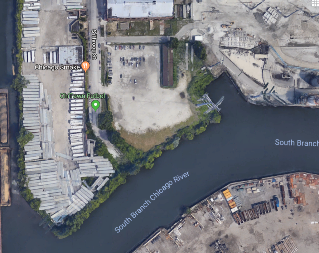
Last week the Chicago Department of Planning and Development held a visioning workshop at MANA Contemporary gallery in Pilsen about the proposed Throop Street River Edge Park. The green space would be located where Throop dead-ends south of Cermak Road, on the north bank of the Chicago River. In attendance at the meeting were local alderman Danny Solis and other community representatives from Pilsen, Bridgeport, Chinatown, and other neighborhoods.
One of the challenges of the site, as outlined at the workshop, is the legacy of industrial land uses in the area. The site was developed with industrial buildings from 1938 to 1988. Between 1889 and 1988, Throop continued south from the site on a bridge over the river. The present condition of the site does not immediately suggest that it would make a good place for recreational space. It’s an empty lot with Commonwealth Edison power lines crossing overhead, and landscape and construction companies have been dumping debris there. The city is currently conducting an environmental review of the site.
The isolated location, its limited access, and the power lines represent challenges to turning the space into a vibrant park. It’s not a site that residents would casually stumble upon, unless drastic changes are made to the built environment.
One of the ways the city hopes to draw visitors to the new green space is to create a connection to the planned El Paseo Trail, which will run along the south side of Cermak near the park. Throop Street River Edge Park could serve a similar role as the access parks that sit alongside the Bloomingdale Trail, aka The 606.
Some of the preliminary project goals are to restore and enhance the natural ecology; provide education, cultural, and recreational programming; and improve access and connections to other nearby parks and broaden riverfront corridor enhancements. Increased access to the Chicago River has been a focus of the city in recent years, including initiatives such as with the 312 RiverRun Trail on the North Side and the Chicago Riverwalk extension in the Loop.
After the formal presentation, participants broke up into small groups to further discuss the potential for the park in Pilsen. City officials wanted input on what the park should look like and any other concerns from from residents. In the small groups, residents created maps of what the park could potentially look like using stickers and markers. In the group I sat in on, the biggest concerns were transportation access to the park, and how to create a safe park in an industrial area. Some people also asked whether the park could serve as a launching point for boaters. However, it’s unclear whether it would be safe for rowers to navigate the edges of the river in that specific location.
After the breakouts, residents shared some of the ideas discussed with the full room. Some people proposed rebuilding the old Throop bridge to connect Pilsen to Bridgeport and to start creating a network of parks along the river. Others proposed creating art along the Commonwealth Edison power line corridor.
Indeed, the lack of connectivity and access to the riverfront site is the biggest barrier to making Throop Street River Edge Park an attractive destination for residents of the surrounding communities. As I biked to the meeting at the gallery, located just north of the river on Throop, I found it hard to navigate the area, since much of this area is privately owned and not bike- or pedestrian-friendly. Sidewalks stop abruptly and there is heavy truck traffic, which is the reality of industrial corridors on the Southwest Side. It would be important to create safer walking and biking access to the new park.
Parks are a much-needed amenity for Southwest Siders. But the planning process has to allow them to be part of the conversation to ensure they benefit from the new recreational spaces.

Streetsblog has migrated to a new comment system. New commenters can register directly in the comments section of any article. Returning commenters: your previous comments and display name have been preserved, but you'll need to reclaim your account by clicking "Forgot your password?" on the sign-in form, entering your email, and following the verification link to set a new password — this is required because passwords could not be carried over during the migration. For questions, contact tips@streetsblog.org.