If you've moved to Chicago at any time since the mid 1980s, you might have wondered why Metra's commuter rail lines don't have a pattern to their names. They aren't colors, letters, or numbers, like the majority of rail transit lines in the world. Some of the 11 lines have similar names: There are three called "UP-something", two called "MD-something", two "something-North" lines, and two "something-West" lines. Finally, there are three routes that use Metra's only electric trains and are all called "Electric District".
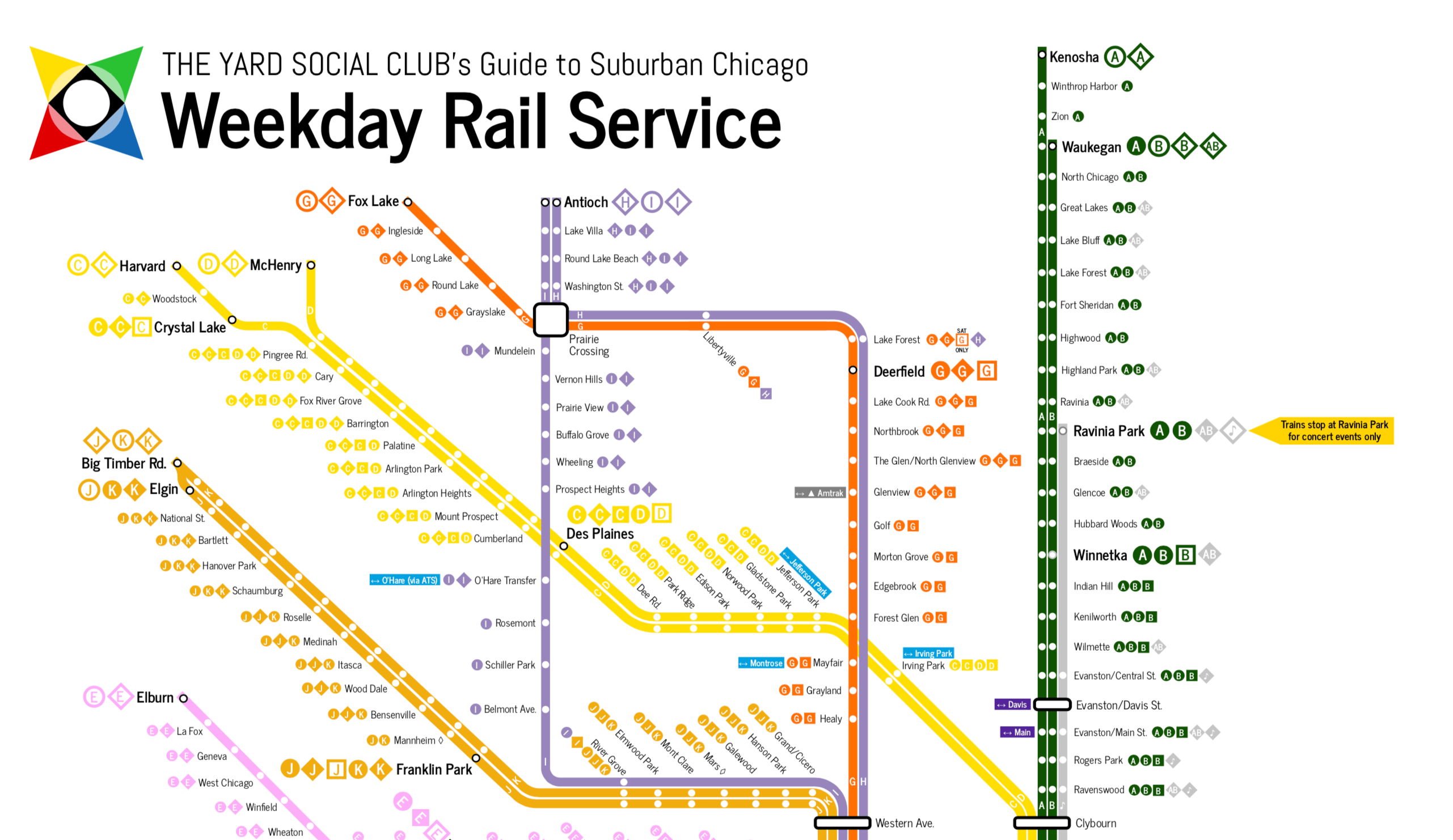
It's that kind of nonsense that Scott Presslak, a former Metra planner, has attempted to correct in his proposed Metra network map redesign (view it full size as a PDF). On the "Diverging Approach" blog, he writes that Metra considers itself a railroad more than a transit agency, and its train lines' service patterns and names reflect that. The blog is published as part of The Yard Social Club, a pro-suburban transit advocacy website.
Most of the line names, the blog post says, are named after the railroads that used to operate the lines before Metra was formed and assumed operation in 1984. Three of them don't fit this pattern – Heritage Corridor, SouthWest Service, and North Central Service. One of the railroads, Milwaukee Road, after which MD-North and MD-West are named, went out of business 32 years ago.
The legacy/host railroad naming scheme made more sense when the RTA first formed Metra back in the early 1980s, but thirty-odd years later it leaves us with a system that’s just that much more difficult to understand unless you’re a daily commuter.
Presslak's map adopts a letter-naming scheme, which is used on the New York City subway, San Francisco light rail, and the Berlin S-Bahn regional express rail, among many other places. Since not all lines serve all stations, Presslak's map separates some stopping patterns into different lines.
For example, Line A is for current Union Pacific North (UP-N) trains that go all the way to Kenosha, Wisconsin, and Line B is for current UP-N trains that stop short of the border in Waukegan. However, regarding this line, Presslak wrote, "I really didn’t even bother trying to decipher the UP-N line, which any casual commuter would definitely need a timetable to fully understand since the trains don’t seem to follow any particular pattern. If you made each particular stopping pattern its own designation, you’d easily get into the hundreds."
It's common on transit networks around the world to have multiple lines going to the same place, so the change from looking up and distinguishing UP-N trains that stop in Rogers Park from ones that don't, to "take Line A" or "take Line B" is pretty simple. Mapping apps on your phone are already set up to do this when you visit cities, like Tokyo and New York City, that have multiple lines and routes to get to the same place.
Now, choosing Line A versus Line B to get from Ogilvie Transportation Center to Rogers Park isn't an issue because there's only one train per hour during the weekdays. Presslak applied the same treatment to the Union Pacific Northwest lines that go to Harvard, McHenry, and Crystal Lake stations.
The lettering scheme would be even more convenient on the Metra Electric District line because it has three branches and some of the branches have express service, making for more than a handful of service patterns. Presslak proposes lines U, V, W, X, Y, and Z for the rebranded "Lake Shore Corridor Service".
The map distinguishes other stopping patterns among lines by using shapes, but I think this complicates the system even more by having the map expand beyond a map and show schedules and timing.
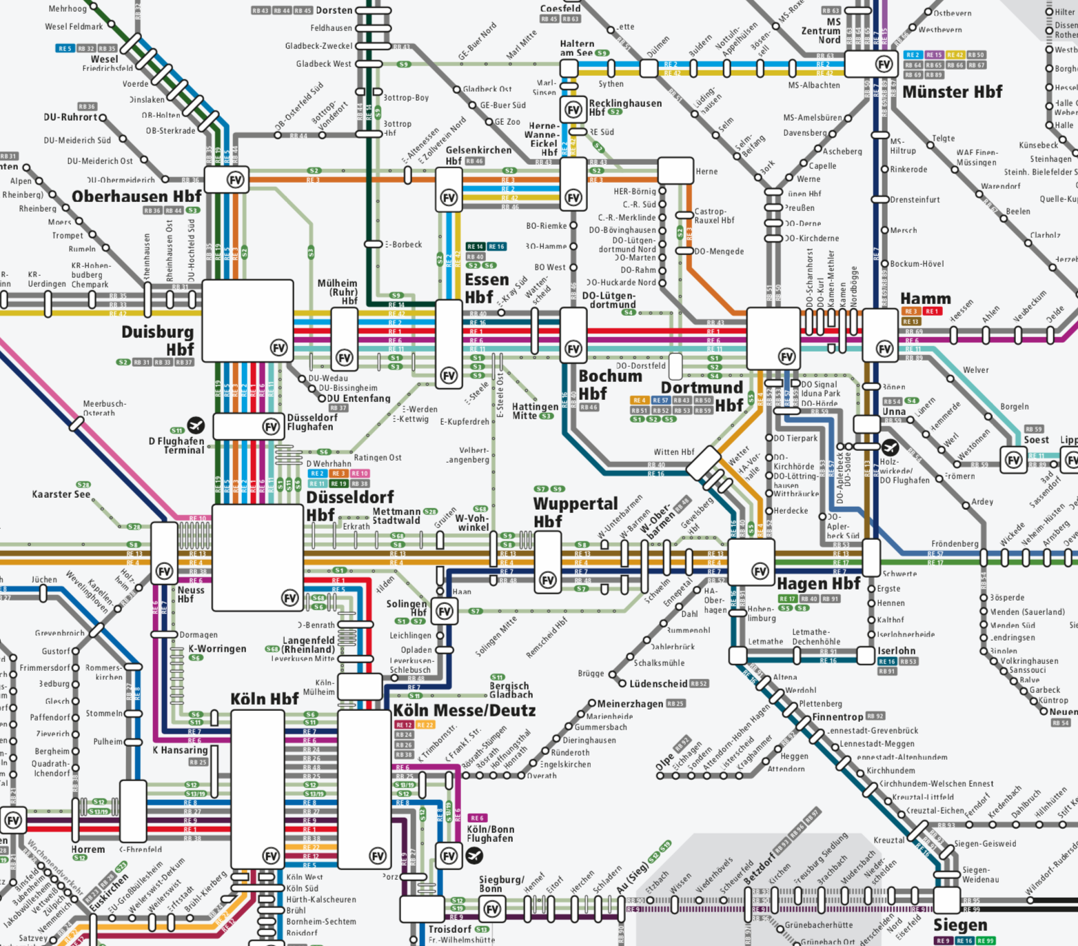
One of my favorite transit maps is the one showing the network of interconnected networks in the state of North Rhine Westphalia, Germany. There are multiple routes that will whisk you from Cologne to Essen, and each line on those routes has varying schedules and stopping patterns. You can take a long-distance train that runs at higher speed, a long-distance train that runs at medium speed, regional trains that run similar to Metra, or even S-bahn trains that are lower capacity than the regional trains but run at higher frequencies and make more stops.
Each line may have hourly service, but aggregate all of the lines and each route between cities has service for residents that's more frequently than once an hour.
(Of course, these kinds of choices are possible because the density of people living in the Rhine-Ruhr region is much higher than the Metra service area, but other regions more akin to Chicagoland are expanding their transit networks, i.e. Toronto., to have better connected and frequent all-day service.)
The North Rhine Westphalia map has no indication about stopping patterns, hours of service, or any time-related information. It's purely a map of all the lines operated by different companies and how they connect. If you want a schedule, it's on a separate document.
Maps and schedules hardly seem to matter in the electronic age, but for those without a charged up smartphone, or need to understand all options when apps are designed to mostly give "here and now" choices, train companies in Germany separate the lines and times by showing schedules separately on large posters at every station.