
Ghost Parcels Show How Urban Highways Squandered Valuable Land
Love that Cook County still keeps track of the parcels under the expressways punched through Chicago pic.twitter.com/wcLXNcbZmM
— Neil (@fitnr) September 22, 2015
Here’s a great illustration of how incredibly destructive and wasteful it is to run elevated highways through cities. New York City-based artist and planning consultant Neil Freeman, who grew up in Chicago, put together these haunting images of Cook County land parcel maps superimposed over aerials of expressway interchanges in the West Loop, River West, Bridgeport and Chinatown.
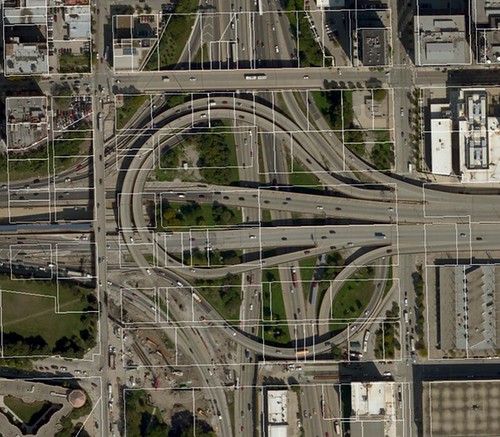
The visuals are a byproduct of a research project Freeman is doing on housing typologies. The base layer is from Bing satellite images, and the parcels are from the Cook County assessor’s office. “Love that Cook County still keeps track of the parcels under the expressways punched through Chicago,” Freeman tweeted.So why does the county still maintain records of property lines that haven’t had meaning since the Richard J. Daley era?
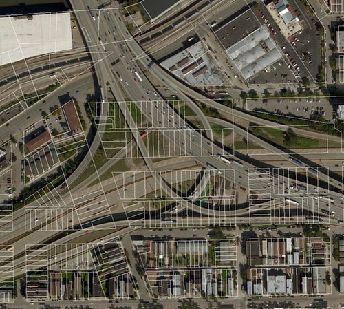
“The reason these parcels under the expressways aren’t just shown as one continuous polygon is because [the Illinois Department of Transportation] never dedicated the parcels as right-of way,” a source at the county told me. “It’s most likely because, like all government agencies nowadays, they’re short-staffed. It’s not a priority task because parcels under elevated highways usually don’t generate any tax revenue.”
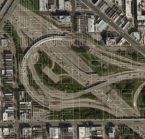
Think about how much money in property and sales taxes were generated by the homes and businesses that formerly stood on these parcels before they fell victim to the wrecking ball so that high-speed roadways could be shoved through the urban fabric. Equally important, think of all the lives that were uprooted in the name of “progress.”


Comments Are Temporarily Disabled
Streetsblog is in the process of migrating our commenting system. During this transition, commenting is temporarily unavailable.
Once the migration is complete, you will be able to log back in and will have full access to your comment history. We appreciate your patience and look forward to having you back in the conversation soon.