City Hopes to Beef Up Transit Service in Streeterville, River North
The city is slowly moving forward with building the Central Loop Bus Rapid Transit project, which will speed bus service between Union Station and Michigan Avenue . Meanwhile, the Chicago Department of Transportation is looking at other ways to improve transit connections between the West Loop train stations and the neighborhoods just north of the Loop with the River North-Streeterville Transit Study.
This spring, CDOT started the process of gathering data about travel markets and preferences in the RNS area, physical and traffic constraints, and other costs, benefits, and impacts of different transit alternatives. The goal is to determine a Locally Preferred Alternative for capital improvements by 2015.
These infrastructure upgrades could be relatively low-tech solutions like restriping travel lane configurations or changing traffic signal times, but the study could also lead to a major investment in grade-separated transit, such as BRT or light rail. The research will be used as supporting documentation when CDOT applies for federal funding for the selected project.
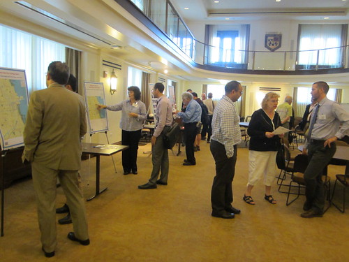
Yesterday, CDOT held an open house at Loyola University’s downtown campus to discuss transit issues and collect feedback from people who live and work in these dense, affluent neighborhoods; another public event is planned for March. “We’ve been engaged in a process of getting public input, and trying to understand the nature of transportation problems in the area,” said Jeff Sriver, the department’s director of transportation planning services.
CDOT has already done significant work to gather info on the travel habits and desires of RNS residents, employees, and visitors, according to Sriver. Surveys for locals are available online, and the department has been distributing the questionnaire on buses and in hotels, and through employers, community organizations, condo associations and other entities. “We’re trying to get feedback on how people use the transit system and the infrastructure that’s in the neighborhood today, and what are the missing pieces,” Sriver said.
A technical advisory committee, which includes representatives of the CTA, Metra, the Chicago Metropolitan Agency for Planning, and the Metropolitan Planning Council, has met twice to discuss the study. A civic advisory committee, made up of members of RNS neighborhood organizations and institutions, has also held two meetings.
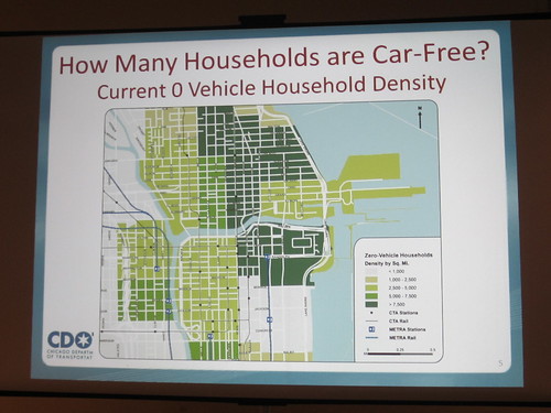
At the open house, attendees were invited to peruse info boards on the RNS transit issues, provide input on what kind of transit improvements they would like to see via the online survey, talk to CDOT staff and brainstorm ideas by placing Post-it notes on a map. A presentation playing on loop noted that some parts of the RNS area have a population density of over 50,000 per square mile. In many parts of these neighborhoods, as well as the River East district, across the river from Streeterville, more than 7,500 households per square mile don’t own cars – that’s eight times the city average.
According to the presentation, one of the first steps for choosing the LPA is determining good corridors for enhanced transit service. These would be long, continuous streets that serve key destinations and already have well-used bus service. The routes should cross the river, on corridors that are appropriate for mass transit – not quiet, residential streets – and they shouldn’t be redundant to existing train lines, the presentation said. An info board identified broad thoroughfares like Congress Parkway and Chicago Avenue as good candidates.
Suggestions left on Post-its included implementing congestion pricing for private cars via traffic cams and E-ZPass-style transponders, wider sidewalks to accommodate more foot traffic, and curb bumpouts at bus stops to facilitate boarding. One attendee called for building a BRT line between the Grand Red Line station and Navy Pier. Another called for consolidating bus stops at Illinois/Michigan and Illinois/Rush, which are only a short distance apart, but can cause buses to get stuck at an additional red light or two.
Retiree Alan Mellis, a familiar face at urban planning hearings, said he objected to the study’s focus on connections to commuter rail stations. “In my mind, all that does is make it easier for people to live outside of the city,” he said. He argued that there should be more emphasis on strategies to make transit an attractive option for locals, such as transforming Chicago Avenue between its namesake Red Line stop and the Magnificent Mile into an attractive boulevard.
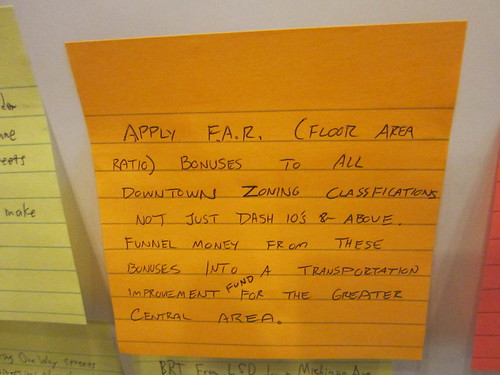
Attendee Shawn Ursini, who works in tourism but has a masters in urban planning, wrote a Post-it regarding floor-area-ratio bonuses, which allow developers to build higher-density structures in exchange for providing a benefit to the public, such as a public plaza at the ground floor. He argued that this system should be applied to all downtown zoning codes, not just the most expensive districts, and that extra revenue from the bonuses should be funneled into transportation improvements.
“Hopefully we can encourage some creative funding mechanisms, so we can do something a little better than just basic transportation improvements,” he said. “We really need to focus on grade-separated transit, so that there’s more than a minimal time savings – that way people will actually use the service.”

Read More:
Streetsblog has migrated to a new comment system. New commenters can register directly in the comments section of any article. Returning commenters: your previous comments and display name have been preserved, but you'll need to reclaim your account by clicking "Forgot your password?" on the sign-in form, entering your email, and following the verification link to set a new password — this is required because passwords could not be carried over during the migration. For questions, contact tips@streetsblog.org.