Western & Belmont Viaduct To Vanish, 1.3 Miles of Wider Sidewalks Planned
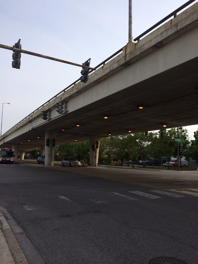
The Chicago Department of Transportation plans to tear down the structurally deficient 52-year-old viaduct that lifts traffic on Western Avenue over the intersection of Belmont and Clybourn. Instead of a gloomy concrete interchange walling off the edge of Roscoe Village, a more conventional surface-level intersection could be built as soon as 2016.
The flyover was built in 1962 to solve motor vehicle traffic woes outside the gates of the long-closed Riverview amusement park. In that highway-happy era, flyovers were a popular approach for bypassing busy intersections. Today, flyovers on arterial city streets are no longer seen as an attractive or economically viable, so CDOT is looking to replace this one with a better, more long-term approach.
The first public meetings regarding the projects took place in the summers of 2009 and 2010. At yesterday’s open house, CDOT and engineers presented updated plans, although with only minor changes since the last presentation in 2010. The project area has expanded beyond its original scope, and now extends five blocks in each direction along Western — from Waveland to Jones, the street across from the City North cinemas just north of the Kennedy Expressway.
The flyover is the focal point of the project. Tearing it down means that Western, Belmont, and Clybourn will become a five-way intersection, through which tens of thousands of motor vehicles will cross every day. Representatives at the meeting were quick to point out that they believe the project will improve traffic flow and safety for all users.
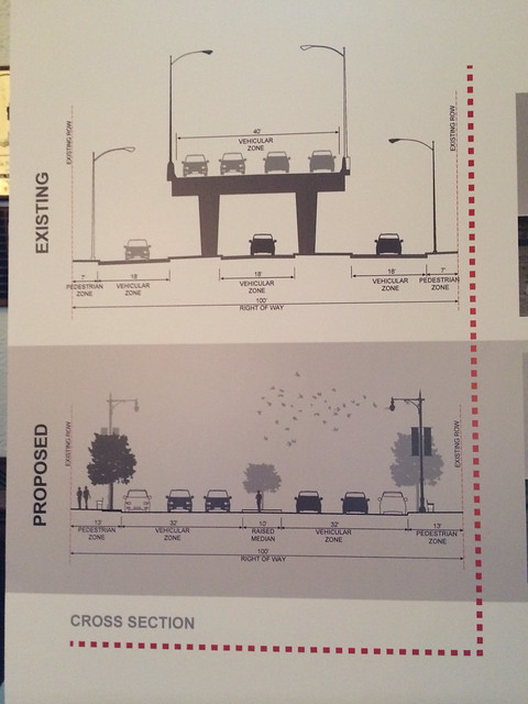
Western will now have two through lanes of traffic, with a third rush-hour only traffic lane in both directions from 7-9 a.m. and 4-6 p.m. on weekdays. Outside of rush hour, both sides of Western will now have approximately 80 new non-metered curbside parking spots. I asked Tim Whalen, project manager for AECOM, if the additional rush hour lanes will create bottlenecks where they end, since Western both north and south of the project area has just two lanes in each direction. Whalen stated that the purpose is to speed the flow along Western and reduce traffic currently forced onto side streets, and that he does not believe traffic will bottleneck where the third lane ends.
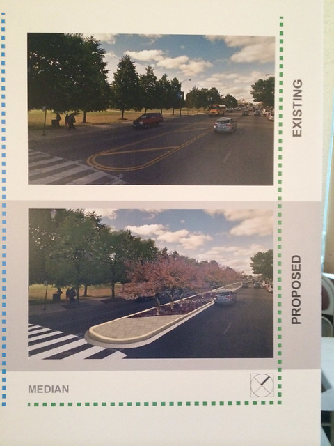
Along the 1.3-mile stretch, including across Western’s bridge over the Chicago River, sidewalks will also be widened to as wide as 13 feet, and amenities such as benches, bike racks, and street trees will be installed. Raised concrete medians with trees will also be installed along many parts of Western, which will calm traffic and provide a refuge for pedestrians crossing the busy street. Aside from crosswalk countdown timers, there are no other plans for pedestrian safety enhancements. No separate bicycle accommodations are planned, since Western is not identified as a bike route in the city’s Streets for Cycling 2020 plan.
There are no current plans to address traffic on side streets by traditional traffic calming measures, something normally left up to individual aldermen. However, new center medians will create a physical barrier so that drivers will be unable to turn left from Western onto some side streets, while still retaining cut-throughs for pedestrian access.
The city’s Pedestrian Plan [PDF, pages 74-75] calls for shortening crossing distances at Chicago’s many diagonal street intersections, as well as providing crosswalks for all pedestrian movements. However, there are no plans to tame the two massive intersections along the corridor where three streets intersect: Western, Diversey, and Elston, and Western, Belmont, and Clybourn. At both, people on foot can walk over 100 feet across many lanes of moving traffic. Another city publication, the Complete Streets guidelines, calls for intersections to be as “compact as possible,” but the current design fails to make any intersections more compact. Even the landscaped, concrete medians end before intersections to make way for left turn lanes.
I also asked about potential improvements to public transportation along the corridor. With over 27,000 average weekday riders, the 49 Western bus route is one of CTA’s busiest. But there are no provisions in CDOT’s plans to improve bus service — again at odds with the Complete Streets guidelines, which prioritize people on foot, transit, and bicycles before those in cars. While CDOT is not currently working with CTA to improve transit along the corridor, EJM representative Lisa Sagami stated that modernized signals could be fitted with traffic signal priority technology that permits buses to move ahead of all other traffic.
Last night’s open house was the last in a series leading to the final design, which will be completed this year, followed by construction to begin in spring 2015 with completion in 2016. Construction could begin next year, contingent on funding from the federal government (80 percent) and 20 percent local funds. No cost figure is available right now, but AECOM’s Tim Whalen estimates the total cost at $26 million.

Streetsblog has migrated to a new comment system. New commenters can register directly in the comments section of any article. Returning commenters: your previous comments and display name have been preserved, but you'll need to reclaim your account by clicking "Forgot your password?" on the sign-in form, entering your email, and following the verification link to set a new password — this is required because passwords could not be carried over during the migration. For questions, contact tips@streetsblog.org.