The new citywide Mellow Chicago Bike Map is on the street for 2 more days
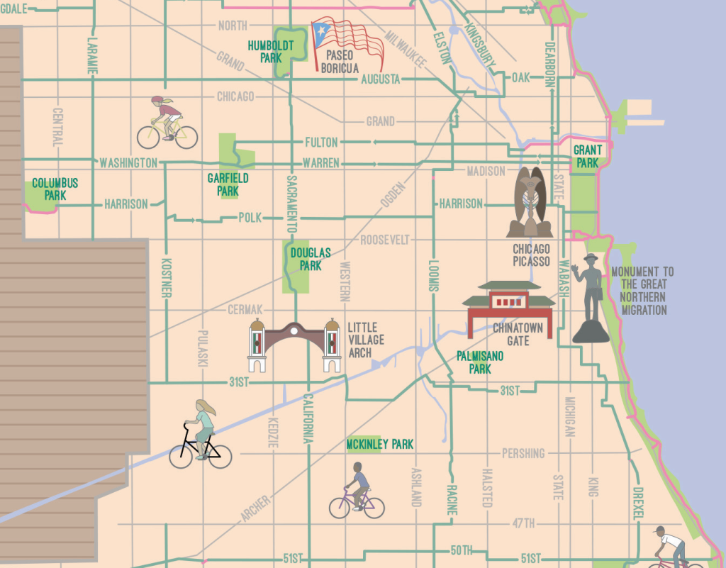
In 2018 Streetsblog Chicago editor John Greenfield collaborated with illustrator Joe Mills and the Chicago Reader on the first version of the Mellow Chicago Bike Map, which highlighted low-stress bike routes in the central city. Earlier this month John, Joe, and the Reader released the Simplified, Citywide Mellow Chicago Bike Map, which goes to the city limits and beyond.
The Illustrated version of the map is available as a two-page centerfold in the current issue of the free paper, which is available at these locations through the afternoon of Thursday, July 24, at these distribution locations around Chicago. The SCMCBM is also available as a much more detailed Google Map for laptop or smartphone navigation. Here’s the backstory of how the new version of the map came to be.
The need for a good Chicago bike map has never been greater.
As I write this, our city is in Phase Four reopening after being devastated by COVID-19, and workplaces have opened their doors again. CTA ridership fell by 80 percent during the pandemic, and many Chicagoans are still avoiding transit, so if we don’t provide safe alternatives to cars for socially distanced trips, we’re sure to see a serious spike in driving, congestion, pollution, and traffic deaths.
For months now, peer cities across the country and around the world have been taking action to facilitate safe, socially distanced walking and biking and prevent future carmageddon by repurposing parking and travel lanes to widen sidewalks and create emergency bus and bike lanes. There’s also a nationwide movement to create “Slow Streets,” residential roadways where through traffic is banned so people can safely walk, roll, jog, and bike in the street, creating corridors for transportation and recreation. That’s crucial, because the United States is currently seeing a major biking boom.
CLICK HERE TO ACCESS THE MAP DIRECTLY ON GOOGLE MAPS
Chicago was late to the party, having done almost nothing to make more room for walking, transit, and cycling during the first few months of the crisis. Meanwhile, Mayor Lori Lightfoot closed the Lakefront Trail and the 606 for about three months, eliminating about 21.5 miles of car-free commuting corridors.
Thankfully those key corridors have reopened with restrictions, and the city has been gradually rolling out several miles of Slow Streets in neighborhoods like South Shore, Kenwood-Oakland, Bucktown, Logan Square, and Ravenswood. But we’re still way behind other U.S. cities. For example, Oakland, California, with a fraction of the population of Chicago, is doing 74 miles of Slow Streets, many times more than our city.
But rather than curse the darkness, we at the Reader decided to light a candle by speeding up the release of the citywide version of our Mellow Chicago Bike Map, which originally covered the area bounded by 95th, Cicero, Devon, and Lake Michigan. This new version stretches from Morgan Park to Rogers Park, Edison Park to Hegewisch, offering low-stress alternative routes, mostly on side streets.
They’re ideal for people from all over town who want to try biking as a socially distanced way to get around that’s also healthy, affordable, good for the environment, and super fun. But even seasoned cyclists will appreciate these quiet, serene roadways where shade offers relief from the summer heat.
If you’re in a hurry and need more direct routes, the city of Chicago’s official bike map is useful for finding marked bikeways on main streets. To avoid clutter on this larger edition of the map, it doesn’t include the points of interest and restaurant and bar recommendations from the original central-city version, but you can still view those at tinyurl.com/MellowChicagoMap.
While I think these routes are generally better for bicyclists, you still should be careful anytime you ride in the city. Feel free to drop me a line with any suggestions for improvements or additions at jgreenfield[at]streetsblog.org.
Some notes:
—I’ve tried to create a grid of low-stress north-south and east-west routes within the city of Chicago, spaced roughly a mile apart.
—To keep the map from getting too cluttered, main-street bikeways, including most diagonal streets, generally aren’t shown—check out the city’s map for these.
—Some routes include a short stretch of sidewalk, or a block where you might have to ride the wrong way on a one-way street. To follow the letter of the law, please dismount and walk your bike at these locations.
Thanks to the following people who have provided feedback on drafts of this map or helped out in other ways: Anne Alt, Elihu Blanks, Shawn Conley, Jeremy Cuebas, Marissa Dolin, Angela Ford, Carolina Gallo, David Griggs, Anna Gunderson, Katherine Hodges, Paul Fitzgerald, Ronnie Matthew Harris, Paul Halupka, Derrick James, Howard Kaplan, Gin Kilgore, Lynda Lopez, Deloris Lucas, Jake Malooley, Danielle McKinney, Beth Medley, Jacob Peters, James Porter, Anjulie Rao, Eric Allix Rogers, Bill Savage, Yasmeen Schuller, Brian Sobolak, Charlie Short, Peter Taylor, Steven Vance, Vera Videnovich, and Jeff Zoline. The route connecting West Town Bikes, the Bloomingdale Trail, the Logan Square Skate Park, and the Garden Chicago Dirt Jumps was originally brainstormed by students from West Town Bikes and is known as “the Circuit.”

Read More:
Streetsblog has migrated to a new comment system. New commenters can register directly in the comments section of any article. Returning commenters: your previous comments and display name have been preserved, but you'll need to reclaim your account by clicking "Forgot your password?" on the sign-in form, entering your email, and following the verification link to set a new password — this is required because passwords could not be carried over during the migration. For questions, contact tips@streetsblog.org.