At Last, the Bloomingdale Looks Like a Trail
In June, Steven Vance and I got a sneak peek at construction to build the Bloomingdale Trail, AKA The 606. On Tuesday, I went back up on the rail line for a tour with Beth White from the Trust for Public Land, which is managing the project, and saw that major progress has been made over the last six months. Work on bridges and utilities is largely complete, access ramps are in place, many blocks of railings have been installed, and most of the 2.7-mile route is paved.
The $95 million multiuse trail and linear park was supposed to debut this fall but construction delays, caused by the long, cold winter, have postponed the opening date until June. The upside of the delay is that more of the landscaping for the path and its access parks will be completed by opening time than was originally planned.
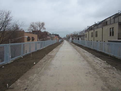
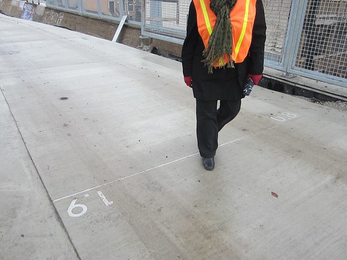
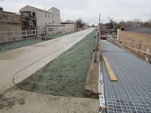
Almost all of the rail line, except for locations currently accessed by heavy trucks, now sports a 14-foot-wide ribbon of concrete that will serve as the walking and biking surface. Mile markers have been embedded in the pavement, and two-foot-wide rubber surfaces will be added to the outside edges of the path to provide a soft surface for running — a similar configuration as the Lakefront Trail.
At community meetings about the Bloomingdale, many attendees asked that there be separate paths for pedestrians and cyclists, in order to avoid the kind of conflicts that are common on the busier sections of the lakeside route. Separating the two different modes on the Lakefront Trail has been the most requested improvement during the North Lake Shore Drive redesign process. The Active Transportation Alliance recently launched a petition calling for separate paths by the lake.
White told me it wasn’t physically possible to build two different paths on the rail line, since the right-of-way averages just 30 feet wide. “If we’d had separate trails, there would have been no green space.” However, the Bloomingdale path undulates in some places, and dips down in others, which may help calm bike traffic. The access ramps for the trail will also feature wheelchair accessible stiles at the trail level and bollards at the bottom, which will discourage cyclists from zooming down the inclines and into the street.
The city’s Bicycling Ambassadors and other workers will be doing outreach to trail users to promote safe, courteous riding, White said. “You’re going to need to share space with people in order to make this work. The nice thing is that if issues arise with people riding too fast, we can always make adjustments to the trail.”
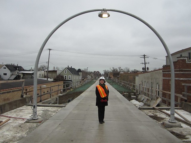
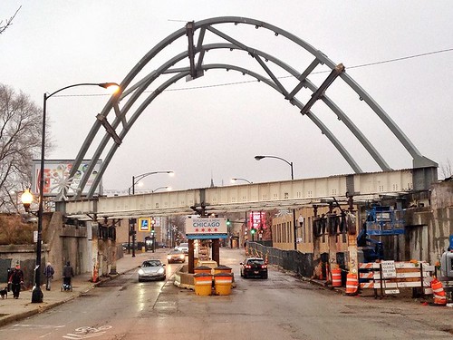
Work on the trail’s 38 bridges is coming to a close. Two weekends ago, workers installed a giant steel arch on the rail line’s Milwaukee bridge. The arch is 98 feet long, 35 feet tall and weights 55,000 pounds, White said. The original bridge decking has been removed, and the span has been elevated by three feet. After suspension wires are installed, the bridge decking will be re-poured, and the street pillars that currently support the bridge will be removed. “Not only will we have a beautiful bridge, but by eliminating the piers, we’ll be making the street safer,” she said.
In April, the rail line’s bridge at Ashland – the trail’s eastern terminus — was taken down and transported a mile west to Western, where it was reinstalled. That bridge will also be pillar-free, White said.
After ascending to the trail from Julia de Burgos Park, located between Whipple and Albany, we walked east to Kimball, where the right-of-way is 120 feet wide, making it the trail’s broadest section. Formerly train cars were stored at this spot. This area will get a small playground, a grove of shade trees, and a short, wheelchair–accessible nature path, separate from the main trail.
Most electrical and plumbing lines have been installed by now, White said. Workers will put in light fixtures and water fountains this winter. Excavation to create the dips in the trail, which also allow for shorter access ramps, has exposed interesting striation in the concrete walls of the old railroad embankment. The walls, which are nine feet thick at street level, will remain in their rough state to remind users of the trail’s history, White said. “One of our staffers pointed out, you wouldn’t put spackle on the Coliseum.”
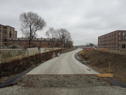
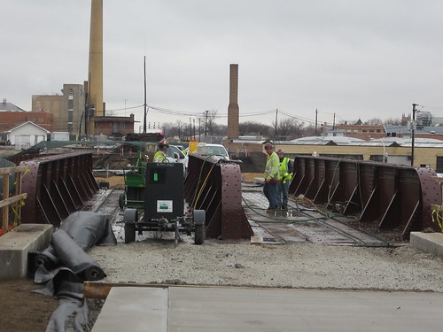
At the Lawndale bridge, by the McCormick Tribune YMCA, workers were installing new decking. Just west of the bridge, at the trail’s western terminus, there’s now a mound of dirt that will be transformed into an observatory that will be accessed via a spiral path. From the top of the mound — ten feet above the rest of the trail — visitors will be able to watch train movements on an adjacent north-south rail line, and view the heavens through telescopes.
To the west of the YMCA stands the shuttered Magid Glove factory, which the Trust for Public Land recently purchased in order to create the trail’s sixth ground-level access park. That green space will open roughly a year and a half after the main trail.
After we turned around and headed east again, we came to the Humboldt Boulevard bridge, which will have bleacher-like seating so that visitors can rest and gaze out at the leafy thoroughfare. While most of the trail will get “cobra-head” lampposts, illumination on the bridge will be provided by lights on arches over the trail. One of these has already been installed.
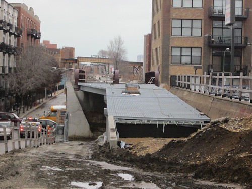
At Western, the installation of bridge decking is not yet finished so we were forced to turn around, but the Milwaukee bridge arches are visible two blocks to the east. Much progress has been made on the trail over the past few months, and it will be exciting to see how it develops between now and the grand opening.

Read More:
Streetsblog has migrated to a new comment system. New commenters can register directly in the comments section of any article. Returning commenters: your previous comments and display name have been preserved, but you'll need to reclaim your account by clicking "Forgot your password?" on the sign-in form, entering your email, and following the verification link to set a new password — this is required because passwords could not be carried over during the migration. For questions, contact tips@streetsblog.org.