Streetsblog’s Irreverent Guide to Chicago Planning Highlights and Lowlights
We’d like to give a warm welcome to urban planners from across the country who are coming to our fair city for the American Planning Association’s national conference, April 13-17. The APA has published an excellent, 46-page Planner’s Guide to Chicago, chock full of Windy City sights and activities that will appeal to attendees, as well as some fascinating historic and contemporary maps.
Those with an interest in bicycle culture might want to check out John Greenfield’s Visitor’s Guide to Biking in Chicago. We’d also like to offer this quick-and-dirty guide to a few of the local planning hotspots we love – and a few we love to hate.
View APA recommendations in a full screen map. Letters on the map pins correspond to the entries below.
The Bad
A. Greenwash Selfish-Park (60 West Kinzie) Billed as “Chicago’s first earth-friendly parking garage,” Greenway Self-Park’s logo features a VW Bug with leaves blowing out of the tailpipes rather than noxious fumes. But just how eco-friendly is a structure that warehouses 715 cars on prime downtown land, a stone’s throw from multiple transit stations? Please let us know if you actually see those corkscrew wind turbines rotate.
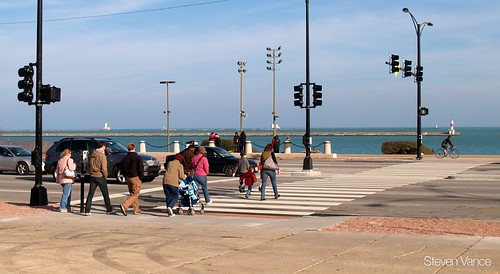
B. Chicago’s Dumbest Intersection (Michigan Avenue and Randolph Street) When Millennium Park opened in 2004, the increase in foot traffic on Michigan led to more conflicts between pedestrians and turning cars. The Richard M. Daley administration’s solution? Remove several crosswalks. This one is the worst example: while it used to be possible to walk directly from the Chicago Cultural Center to the park, now it’s necessary to make three street crossings.
C. Union Station Traffic Snafu (Canal Street and Jackson Boulevard) Best observed during the afternoon rush hour, this confluence of half a dozen bus routes, idling coach buses, hundreds of taxis and thousands of pedestrians per hour can make crossing the street here, or just driving or biking straight, an ordeal. The city has a Union Station Master Plan that recommends interventions, and the Chicago Department of Transportation is building an off-street transportation center just south of the station for bus/train connections that should make traffic more predictable.
D. Faux-HAWK (Monroe Street east of Michigan Avenue) After the Modern Wing at the Art Institute of Chicago opened across from Millennium Park in 2009, many people made a hazardous mid-block crossing between the attractions. The museum paid for a talking crosswalk that doesn’t actually solve the problem. Speeding drivers still don’t always see, slow or stop for people crossing the street. A pedestrian-activated Rectangular Rapid Flash Beacon (similar to a HAWK beacon) was taken out by a car months ago, but a sign still tells peds to “Thank the driver” for stopping as you cross the roadway.
E. Fullerton Avenue Fiasco (Fullerton Avenue at Lake Shore Drive) Here’s another Daley-era design that eliminates conflicts between pedestrians and cars by removing the pedestrians. Formerly, it was possible to safely walk or bike under Lake Shore Drive to the lakefront via the sidewalk on the south side of Fullerton, a de-facto multiuse path. To make it easier for cars on Fullerton to turn south onto the drive, the sidewalk was removed to make room for a second on-ramp lane. Now pedestrians and cyclists are supposed take an extremely circuitous ramps-and-underpass route to the beach.
F. Chicago/Ogden/Milwaukee Crash Zone (intersection of Chicago, Ogden and Milwaukee avenues) Our city is known for its nearly seamless street grid, but not so much for its six-way intersections. A skewed street configuration, outdated traffic signal programming, and high car and bike traffic volumes makes this six-way one of the top locations for bike crashes every year. Last summer a speeding cabbie killed a pedestrian here.
The Good
G. Queen’s Landing Crosswalk (500 South Lake Shore Drive) The Daley administration’s most blatantly pro-car, anti-pedestrian maneuver was the 2005 removal of the dedicated walk signal and crosswalk at Queen’s Landing, between the lakefront and Buckingham Fountain. While the removal saved motorists a minute or two of wait time, it forced people on foot to take a ten-minute detour. As part of a wave of ped improvements under Rahm Emanuel, the city reinstalled the crosswalk and signal on Thanksgiving Day 2011, definitely something to give thanks for.
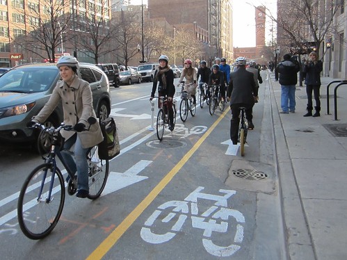
H. Chocolate-Scented Bike Lane (Kinzie Street from Desplaines to Wells streets) There’s lots to love about Chicago’s flagship protected bike lane, the first half-mile of 100 miles of protected and buffered lanes Rahm Emanuel has promised to install in his first term. Since lines of parked cars shelter cyclists from moving vehicles, protected lanes are just the ticket to help newbies feel comfortable riding on city streets. Best of all is the location, next to the fragrant Blommer Chocolate factory.
I. Milwaukee/North/Damen Mashup (Milwaukee, North and Damen avenues) The chaotic epicenter of the hip Wicker Park-Bucktown area would be a great place to install Chicago’s first pedestrian scramble, something CDOT Commissioner Gabe Klein has expressed interest in piloting. This would also be an obvious place to implement the city’s new Complete Streets guidelines as they apply to complex intersections. Check out the view from the adjacent Blue Line platform, as well as the city’s first on-street bike parking corral at 1579 North Milwaukee.
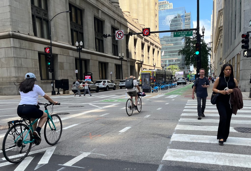
J. Dearborn Two-Way Protected Bike Lane (Dearborn Street between Polk and Kinzie streets) It was a great day in Chicago last December when Mayor Emanuel cut the ribbon on the city’s first two-way protected lane, complete with dedicated bike traffic signals. Building it required removing a travel lane, a gutsy thing to do in the heart of the Loop business district. While the lanes are a bit narrow, this bikeway, over a mile long, is our favorite in the city because it provides a major reduction in cycling stress.
K. Chicago Riverwalk (south bank of the Chicago River from Lake Michigan to State Street) Right now you can take an uninterrupted stroll or pedal almost a mile from the lakefront to Vietnam Veteran’s Memorial Park. Ray LaHood recently announced federal funding that will allow Chicago to extend the riverwalk several blocks west, a roughly $100 million project slated for completion in 2016. With waterfront cafes, kayak rental, a play fountain, fishing piers, floating gardens and more, this new, glitzier riverwalk section should be pretty frickin’ cool.
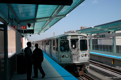
‘L’. CTA Green/Pink Line Morgan Stop (Lake and Morgan streets) Opened last year, Chicago’s most beautiful ‘L’ station features sleek green canopies sheltering customers as they wait for their ride, plus a fully enclosed glass skybridge between the platforms, great for photographing the trains and skyline. Downstairs, sidewalks on both Lake and Morgan were widened to make room for the station houses and artistic, circular bike racks, the product of a design competition. The whole facility is an architect’s delight, and a relative bargain at only $38 million.
M. Public Space Nirvana in Andersonville (Clark Street between Argyle and Olive streets) This Portlandia-esque neighborhood is ahead of the curve when it comes to sustainable transportation and public space initiatives. Last year the Clark Street business strip, one of Chicago’s most vibrant pedestrian retail districts, became home to one of the city’s first “People Spots,” which replaced parking spaces with a miniature park, as well as two on-street bike parking corrals. Another parklet and several more corrals will debut this summer.

N-S. Other Fantastic Stuff (various locations) We also highly recommend taking (N) a Chicago Architecture Foundation architectural river cruise; (O) checking out Palmisano/Stearns Quarry Park in Bridgeport and (P) Ping Tom Park in Chinatown; (Q) strolling the Chicago Museum Campus after looking at photos of what it used to be like before Lake Shore Drive was reconfigured; (R) cruising Northerly Island Park on a bike; (S) hiking the Northwest Side’s dormant Bloomingdale Line, slated to become a trail and “linear park”; (T) Strolling the Bronzeville Walk of Fame, including the iconic Bronzeville Victory Monument.
The Ugly
U. Navy Pier Flyover The Lakefront Trail is one of Chicago’s sustainable transportation treasures, a scenic, uninterrupted, 18.5-mile greenway. Actually, make that “semi-uninterrupted” – there’s a gnarly bottleneck where the path crosses the river, and dangerous intersections with Illinois Street and Grand Avenue near the pier, Illinois’ busiest tourist attraction. The planned $44.5 million flyover would allow cyclists to soar over these problem areas, but Steven Vance has proposed a much simpler, cheaper solution. Either way, we’ll be happy to see Chicago’s gem of a bike path get a little more sparkle.

Read More:
Streetsblog has migrated to a new comment system. New commenters can register directly in the comments section of any article. Returning commenters: your previous comments and display name have been preserved, but you'll need to reclaim your account by clicking "Forgot your password?" on the sign-in form, entering your email, and following the verification link to set a new password — this is required because passwords could not be carried over during the migration. For questions, contact tips@streetsblog.org.